

The Severe Thunderstorm Warning For Southeastern Greene County Is Cancelled

…THE SEVERE THUNDERSTORM WARNING FOR SOUTHEASTERN GREENE COUNTY IS CANCELLED…
The storms which prompted the warning have moved out of the area. Therefore, the warning has been cancelled. A Tornado Watch remains in effect until 700 PM CDT for west central Alabama. To report severe weather, contact your nearest law enforcement agency. They will relay your report to the National Weather Service Birmingham.
A Severe Thunderstorm Warning Remains In Effect Until 5:45 PM CDT For Southeastern Greene County
Mar 14th @ 5:18 pm

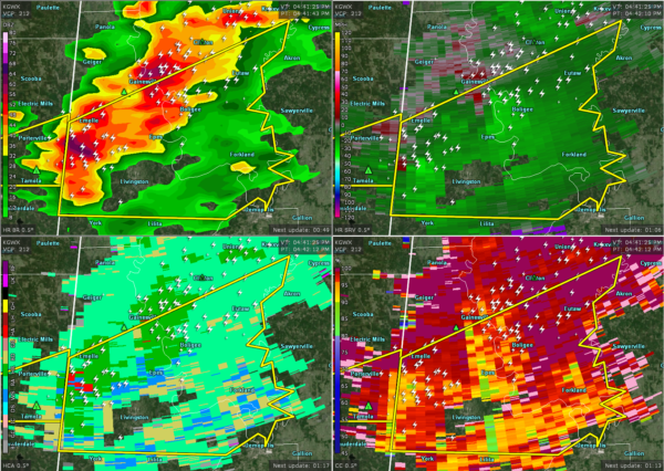
…A SEVERE THUNDERSTORM WARNING REMAINS IN EFFECT UNTIL 545 PM CDT FOR SOUTHEASTERN GREENE COUNTY… At 517 PM CDT, severe thunderstorms were located along a line extending from near Knoxville to Tishabee, moving northeast at 40 mph.
HAZARD…60 mph wind gusts and quarter size hail.
SOURCE…Radar indicated.
IMPACT…Hail damage to vehicles is expected. Expect wind damage to roofs, siding, and trees. Locations impacted include… Eutaw, Forkland, Boligee, Thornhill, Allison, Walden Quarters, Tishabee, Five Points Intersection, I 20 Rest Area Near Eutaw and Eutaw Municipal Airport.
A Severe Thunderstorm Warning Remains In Effect Until 5:45 PM CDT For Central Greene And Central Sumter Counties
Mar 14th @ 5:01 pm

…A SEVERE THUNDERSTORM WARNING REMAINS IN EFFECT UNTIL 545 PM CDT FOR CENTRAL GREENE AND CENTRAL SUMTER COUNTIES… At 501 PM CDT, severe thunderstorms were located along a line extending from near Eutaw to Livingston, moving east at 50 mph.
HAZARD…60 mph wind gusts and quarter size hail.
SOURCE…Radar indicated.
IMPACT…Hail damage to vehicles is expected. Expect wind damage to roofs, siding, and trees. Locations impacted include… Livingston, Eutaw, Forkland, Boligee, Gainesville, Epes, Allison, Walden Quarters, The University Of West Alabama, Bluffport, Thornhill, Tishabee, Duffys Bend, Eutaw Municipal Airport, Five Points Intersection and I 20 Rest Area Near Eutaw.
Severe Thunderstorm Warning Issued For Parts Of Greene And Sumter Counties Until 5:45PM
Mar 14th @ 4:42 pm

The National Weather Service in Birmingham has issued a
* Severe Thunderstorm Warning for…
Southern Greene County in west central Alabama…
Central Sumter County in west central Alabama…
* Until 545 PM CDT.
* At 441 PM CDT, a severe thunderstorm was located near Boyd, or 9 miles northwest of Livingston, moving east at 40 mph.
HAZARD…60 mph wind gusts and quarter size hail.
SOURCE…Radar indicated.
IMPACT…Hail damage to vehicles is expected. Expect wind damage to roofs, siding, and trees.
* Locations impacted include…
Livingston, Eutaw, York, Forkland, Boligee, Gainesville, Epes, Emelle, Walden Quarters, The University Of West Alabama, Thornhill, Dug Hill, Tishabee, Boyd, Allison, Duffys Bend, Bluffport, Belmont, Sumterville and Eutaw Municipal Airport.
Category: ALL POSTS
About the Author (Author Profile)
Subscribe
If you enjoyed this article, subscribe to receive more just like it.


