A Severe Thunderstorm Warning Remains In Effect Until 5:30 PM CDT For Northeastern Jefferson County

…A SEVERE THUNDERSTORM WARNING REMAINS IN EFFECT UNTIL 530 PM CDT FOR NORTHEASTERN JEFFERSON COUNTY… At 516 PM CDT, a severe thunderstorm was located over Morris, or near Gardendale, moving east at 35 mph.
HAZARD…60 mph wind gusts and quarter size hail.
SOURCE…Radar indicated.
IMPACT…Hail damage to vehicles is expected. Expect wind damage to roofs, siding, and trees. Locations impacted include… Northeastern Birmingham, Gardendale, Fultondale, Center Point, Clay, Pinson, Tarrant, Warrior, Kimberly, Morris, Trafford, Chalkville, Palmerdale, Village Springs and New Castle.
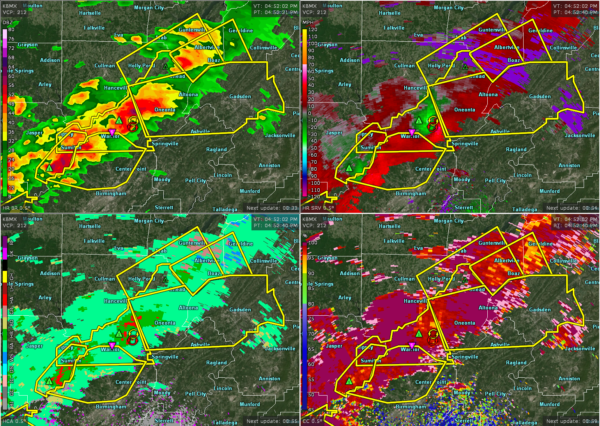
A Severe Thunderstorm Warning Remains In Effect Until 5:30 PM CDT For Northeastern Jefferson County
Mar 14th @ 5:09 pm

…A SEVERE THUNDERSTORM WARNING REMAINS IN EFFECT UNTIL 530 PM CDT FOR NORTHEASTERN JEFFERSON COUNTY… At 508 PM CDT, severe thunderstorms were located along a line extending from Warrior to Graysville, moving east at 40 mph.
HAZARD…60 mph wind gusts and half dollar size hail.
SOURCE…Radar indicated.
IMPACT…Hail damage to vehicles is expected. Expect wind damage to roofs, siding, and trees. Locations impacted include… Northeastern Birmingham, Gardendale, Fultondale, Center Point, Clay, Pinson, Tarrant, Adamsville, Warrior, Kimberly, Graysville, Morris, Brookside, Trafford, County Line, Cardiff, Ketona Lakes, Chalkville, Forestdale and Sayre.
A Severe Thunderstorm Warning Remains In Effect Until 5:30 PM CDT For Northern Jefferson County
Mar 14th @ 4:59 pm

…A SEVERE THUNDERSTORM WARNING REMAINS IN EFFECT UNTIL 530 PM CDT FOR NORTHERN JEFFERSON COUNTY… At 459 PM CDT, severe thunderstorms were located along a line extending from near Warrior to West Jefferson, moving east at 40 mph.
HAZARD…Golf ball size hail and 60 mph wind gusts.
SOURCE…Radar indicated.
IMPACT…People and animals outdoors will be injured. Expect hail damage to roofs, siding, windows, and vehicles. Expect wind damage to roofs, siding, and trees. Locations impacted include… Northern Birmingham, Gardendale, Fultondale, Sumiton, Center Point, Clay, Pinson, Tarrant, Adamsville, Warrior, Kimberly, Graysville, Morris, Brookside, Mulga, Trafford, Maytown, West Jefferson, County Line and Cardiff.
Severe Thunderstorm Warning Issued For Parts Of Jefferson County Until 5:30PM
Mar 14th @ 4:51 pm

The National Weather Service in Birmingham has issued a
* Severe Thunderstorm Warning for…
Northern Jefferson County in central Alabama…
* Until 530 PM CDT.
* At 451 PM CDT, severe thunderstorms were located along a line extending from near Sumiton to near Gorgas Steam Plant, moving east at 40 mph.
HAZARD…60 mph wind gusts and quarter size hail.
SOURCE…Radar indicated.
IMPACT…Hail damage to vehicles is expected. Expect wind damage to roofs, siding, and trees.
* Locations impacted include…
Northern Birmingham, Gardendale, Fultondale, Sumiton, Center Point, Clay, Pinson, Tarrant, Adamsville, Warrior, Kimberly, Graysville, Morris, Brookside, Mulga, Trafford, Maytown, West Jefferson, County
Line and Cardiff.
Category: ALL POSTS
About the Author (Author Profile)
Subscribe
If you enjoyed this article, subscribe to receive more just like it.


