A Severe Thunderstorm Warning Remains In Effect Until 6:15 PM CDT For Etowah And Northeastern St. Clair Counties

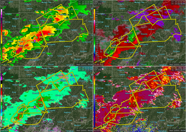
…A SEVERE THUNDERSTORM WARNING REMAINS IN EFFECT UNTIL 615 PM CDT FOR ETOWAH AND NORTHEASTERN ST. CLAIR COUNTIES… At 553 PM CDT, a severe thunderstorm was located over Gadsden, moving east at 35 mph.
HAZARD…60 mph wind gusts and quarter size hail.
SOURCE…Radar indicated.
IMPACT…Hail damage to vehicles is expected. Expect wind damage to roofs, siding, and trees. Locations impacted include… Gadsden, Rainbow City, Attalla, Hokes Bluff, Glencoe, Ashville, Sardis City, Steele, Altoona, Walnut Grove, Reece City, Tabor Road, Aurora, Ballplay, Gadsden Mall, Noccalula Falls, Neely Henry Lake, Southside, Whitney Junction and Alabama International Dragway.
Severe Thunderstorm Warning Issued For Parts Of Blount, Etowah, And St. Clair Counties Until 6:15PM
Mar 14th @ 4:54 pm

The National Weather Service in Birmingham has issued a
* Severe Thunderstorm Warning for…
Southeastern Blount County in central Alabama…
Etowah County in northeastern Alabama…
Northeastern St. Clair County in central Alabama…
* Until 615 PM CDT.
* At 452 PM CDT, a severe thunderstorm was located over Locust Fork, or 8 miles southwest of Cleveland, moving east at 35 mph.
HAZARD…60 mph wind gusts and quarter size hail.
SOURCE…Radar indicated.
IMPACT…Hail damage to vehicles is expected. Expect wind damage to roofs, siding, and trees.
* Locations impacted include…
Gadsden, Rainbow City, Boaz, Oneonta, Attalla, Hokes Bluff, Blountsville, Cleveland, Glencoe, Ashville, Sardis City, Locust
Fork, Steele, Altoona, Snead, Susan Moore, Walnut Grove, Reece
City, Allgood and Fairview.
Category: ALL POSTS
About the Author (Author Profile)
Subscribe
If you enjoyed this article, subscribe to receive more just like it.


