

A Severe Thunderstorm Warning Remains In Effect Until 5:45 PM CDT For Southeastern Clay County

…A SEVERE THUNDERSTORM WARNING REMAINS IN EFFECT UNTIL 545 PM CDT FOR SOUTHEASTERN CLAY COUNTY… At 534 PM CDT, a severe thunderstorm was located near Malone, or 7 miles southwest of Lake Wedowee, moving east at 45 mph.
HAZARD…60 mph wind gusts and quarter size hail.
SOURCE…Radar indicated.
IMPACT…Hail damage to vehicles is expected. Expect wind damage to roofs, siding, and trees. Locations impacted include… Mellow Valley and Motley.
A Severe Thunderstorm Warning Remains In Effect Until 5:45 PM CDT For Southern Clay County
Mar 25th @ 5:15 pm

…A SEVERE THUNDERSTORM WARNING REMAINS IN EFFECT UNTIL 545 PM CDT FOR SOUTHERN CLAY COUNTY… At 515 PM CDT, a severe thunderstorm was located near Ashland, moving east at 45 mph.
HAZARD…60 mph wind gusts and quarter size hail.
SOURCE…Radar indicated.
IMPACT…Hail damage to vehicles is expected. Expect wind damage to roofs, siding, and trees. Locations impacted include… Lineville, Ashland, Cragford, Roselle, Millerville, Mellow Valley and Motley.
Severe Thunderstorm Warning Issued For Parts Of Clay County Until 5:45PM
Mar 25th @ 4:56 pm
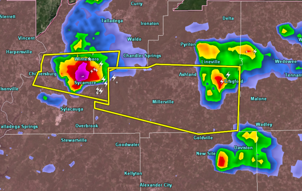

The National Weather Service in Birmingham has issued a
* Severe Thunderstorm Warning for…
Southern Clay County in east central Alabama…
* Until 545 PM CDT.
* At 456 PM CDT, a severe thunderstorm was located over Sycamore, or 7 miles northeast of Sylacauga, moving east at 45 mph.
HAZARD…60 mph wind gusts and half dollar size hail.
SOURCE…Radar indicated.
IMPACT…Hail damage to vehicles is expected. Expect wind damage to roofs, siding, and trees.
* Locations impacted include…
Lineville, Ashland, Cragford, Roselle, Millerville, Mellow Valley and Motley.
Category: ALL POSTS
About the Author (Author Profile)
Subscribe
If you enjoyed this article, subscribe to receive more just like it.


