Some Thin Clouds But Mild & Nice Just After Midday
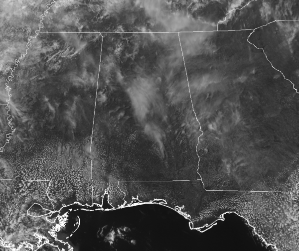
CONDITIONS AT 1:30 PM
It’s a clean sweep on radar as we have moved into the early afternoon hours on this final Friday of March 2019, but we can’t say that about the latest visible satellite image for Central Alabama. We have some high thin clouds across much of the area which is filtering out the sunshine somewhat but it still a relatively bright day outdoors. Temperatures are currently in the lower to mid-70s across the area with a few spots tied at 70º for the cool spots. Birmingham was at 72 degrees while a few spots were tied at 75º as the warm spots.
WEATHER FOR THE REST OF YOUR FRIDAY
We’ll continue to have filtered sunshine through the rest of the afternoon and into the early evening hours as some higher thin clouds continue to float overhead. Those clouds will not hold back the temperatures as we’ll get up into the mid to upper 70s throughout the area. Clouds will be on the increase throughout the late night and overnight hours, but temperatures will not dip down all that far due to the cloud cover. Temperatures will start off in the upper 60s to the lower 70s around 7:00 pm, dropping into the lower to mid-60s by 10:00 pm, and eventually down to the lower to mid-50s for the overnight lows.
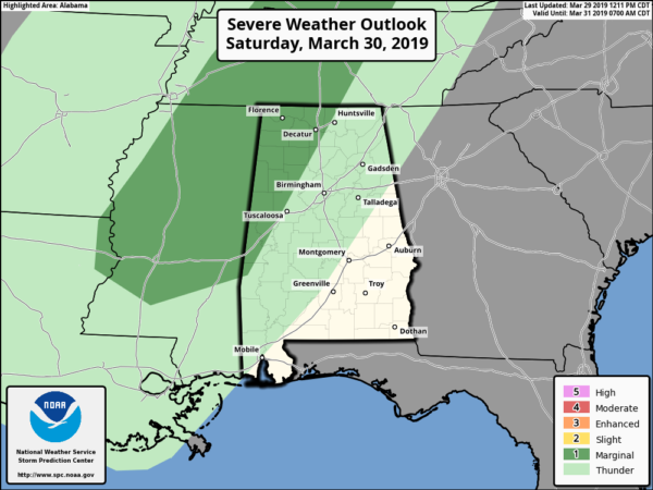
POTENTIAL FOR A FEW STRONG TO SEVERE STORMS ON SATURDAY AFTERNOON & EVENING
As of the latest update just after the beginning of the noon hour, SPC has a Marginal Risk defined over the west and northwestern parts of North/Central Alabama for Saturday. This includes locations west of a line from Bellamy (Sumter Co.) to Jasper (Walker Co.) to Hazel Green (Madison Co.). Timing for the best chances of stronger to severe storms will be from 3:00 pm to 9:00 pm in the risk locations. Threats are from damaging winds up to 60 MPH and large hail up to quarter-size.
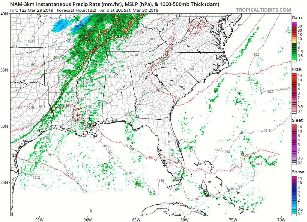
We have the possibility of a few storms developing out ahead of the main squall line and cold front during the early afternoon hours with the possibility of a few of those becoming strong to marginally severe around the 3:00 pm hour. Those will progress across the area out ahead of the main squall line which will enter the northwest corner of the state between 7:00 pm and 9:00 pm. Storms will be weakening as the line enters the state, and while a couple of cells within the line may be strong, the threat of organized severe weather should be done for the evening. Moisture return out ahead of the front is lacking, therefore the threat of tornadoes is very low… not zero… but very close.
We’ll have some sun at times throughout the morning and into the early afternoon hours before more clouds start to roll in with the approaching system. Remember, any extra sunshine we get will only help to further destabilize the atmosphere. Afternoon highs will top out in the mid-70s to around 80º across the area. As I mentioned earlier with the moisture return, the dewpoints will stay below the magic number of 60º throughout Central Alabama, but it will be very close in the Marginal Risk areas.
SKIES CLEAR BUT THE DAY WILL BE BREEZY & COOLER ON SUNDAY
Rain should be out of the Central Alabama area by just after sunrise on Sunday morning, but we may have one or two lingering showers during the morning. Skies will begin to clear out but it will be quite a breezy and cooler day. Afternoon highs will be in the mid-50s to the mid-60s across the area with winds out of the north at 10 MPH with gusts reaching up to 20 MPH at times.
THE START OF THE HONDA INDY GRAND PRIX OF ALABAMA WEEKEND IS 1 WEEK AWAY
The Honda Indy Grand Prix of Alabama will be April 5-7 at the beautiful Barber Motorsports Park! Make plans for the event that has been voted “Best Annual Event” & “Best Sporting Event” in Birmingham. Kids 15 & under are admitted free with a ticketed adult, and three-day general admission tickets are $69. Single day tickets are as low as $15. Pack a picnic/cooler and bring the family out for a weekend full of activities and racing! To get your tickets, CLICK HERE.
As of now, it is too early for an “official forecast,” but models are disagreeing in rainfall for the weekend. My latest thoughts on the weather for the #HIGPA weekend are up on our HIGPA Forecast page.
BEACH FORECAST CENTER
Get the latest weather and rip current forecasts for the beaches from Fort Morgan to Panama City on our Beach Forecast Center page. There, you can select the forecast of the region that you are interested in.
ALREADY OFF TO A HOT START IN 2019! ADVERTISE WITH THE BLOG!
We have enjoyed over 5.7 MILLION page views on AlabamaWx.com so far in 2019! Don’t miss out! We can customize a creative, flexible and affordable package that will suit your organization’s needs. Contact Bill Murray at (205) 687-0782.
E-FORECAST
Get the Alabama Wx Weather Blog’s Seven-Day Forecast delivered directly to your inbox by email twice daily. It is the most detailed weather forecast available in Central Alabama. Subscribe here… It’s free!
CONNECT WITH THE BLOG ON SOCIAL MEDIA
You can find the AlabamaWx Weather Blog on the major social media networks:
Facebook
Twitter
Instagram
WEATHERBRAINS
Don’t forget you can listen to our weekly 90 minute netcast anytime on the web at WeatherBrains.com or on iTunes, Stitcher, or Spotify. This is the show all about weather featuring many familiar voices, including the meteorologists at ABC 33/40.
Category: Alabama's Weather, ALL POSTS
About the Author (Author Profile)
Scott Martin is an operational meteorologist, professional graphic artist, musician, husband, and father. Not only is Scott a member of the National Weather Association, but he is also the Central Alabama Chapter of the NWA president. Scott is also the co-founder of Racecast Weather, which provides forecasts for many racing series across the USA. He also supplies forecasts for the BassMaster Elite Series events including the BassMaster Classic.Subscribe
If you enjoyed this article, subscribe to receive more just like it.


