A Mid-Morning Update On The Potential For Severe Storms
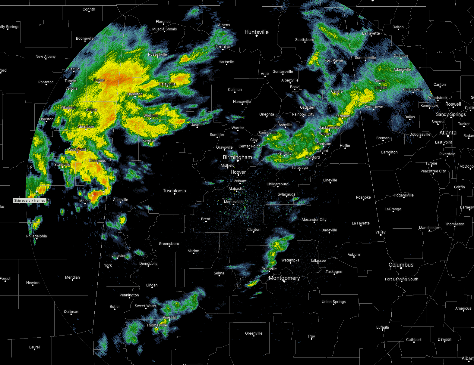
At 10:45 am, radar shows most of the shower activity is located over the northwestern parts of North/Central Alabama, with a few scattered showers over the northeastern parts and over the southern parts of the area. All of this activity is moving to the northeast with the southern showers dissipating as the morning progresses. There is actually some breaks in the cloud cover that is allowing for some sun to warm the surface, which is actually bad news. If we get any sunshine, that may help destabilize the atmosphere for more showers and storms to form later this afternoon.
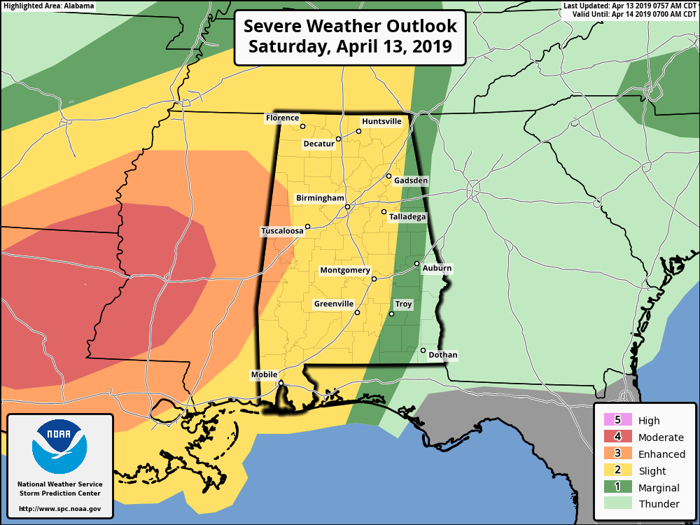
SPC has nearly all of North/Central Alabama in a risk for severe storms on their Day 1 Outlook valid from 7:00 am this morning to 7:00 am Sunday morning. An Enhanced Risk is up for locations west of a line from Sulligent to Gordo to Eutaw. A Slight Risk extends out from that to as far east as Fort Payne to Alexander City to Troy. A Marginal Risk is up as far east as Roanoke to Opelika to Blue Springs.
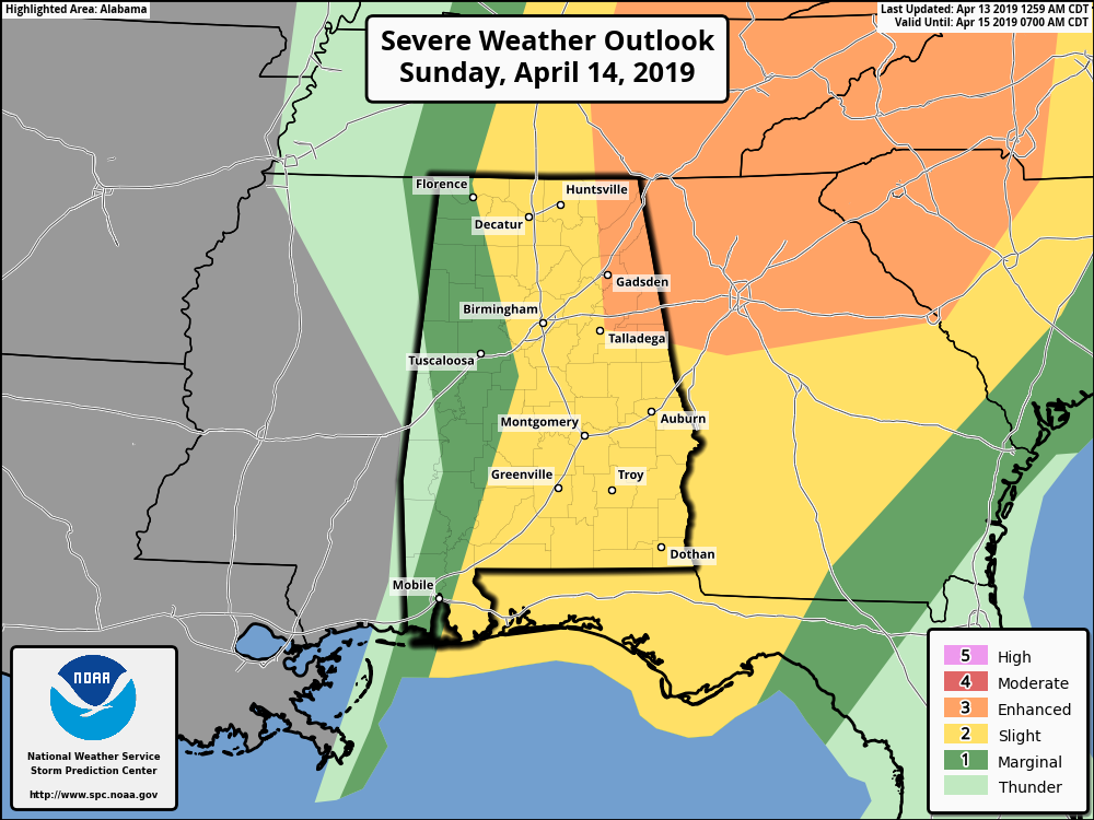
On the Day 2 Outlook valid from 7:00 am Sunday to 7:00 am Monday, SPC has an Enhanced Risk up for locations east of a line from Hytop to Rainbow City to Talladega. A Slight Risk is up for locations east of a line from Florence to West Blocton to Orrville. A Marginal Risk is up for nearly the rest of the area except for locations west of a line from Macedonia to Myrtlewood.
The main threats throughout the entire event will be from tornadoes and damaging winds up to and in excess of 60 MPH. We do have the possibility for stronger long-track tornadoes (EF2 and above) across all of Central Alabama, but at this point, the higher probability of those will be west of the I-65 corridor. There is a smaller threat of large hail up to one-inch in diameter across the area as well.
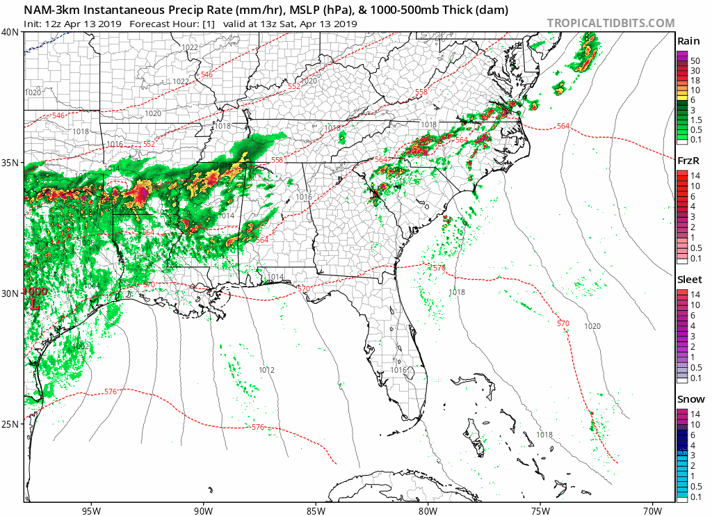 12z NAM-3k Simulated Radar vaalid through 12:00 am Monday.
This animation shows that the morning activity should be out of the state and up into Tennessee by the 2:00 pm hour and we’ll mostly stay dry throughout the rest of the afternoon and evening hours. I say mostly because there is a chance that we could get some cells to develop with the heating of the day that may become strong and race quickly to the north-northeast. We’ll have to watch and see if any of these can bust through the cap and start to rotate. If this happens, then we could see some damaging winds and maybe a tornado. The chances of this happening is rather small at this point, but not zero.
We could see storms rolling into the western parts of the area as early as midnight tonight and progress through the area throughout the overnight and into the morning hours, and exiting into Georgia by the noon hour. There will be more showers and storms that will form behind the main line of cells that will be along the cold front. We’ll have to watch these as they may have the possibility to become strong, but we don’t expect any of these to become severe. All of the activity, including any stray wrap-around moisture, should be out of the area by 12:00 am Monday.
Any watches that are issued before the storms arrive in the area will be Tornado Watches.
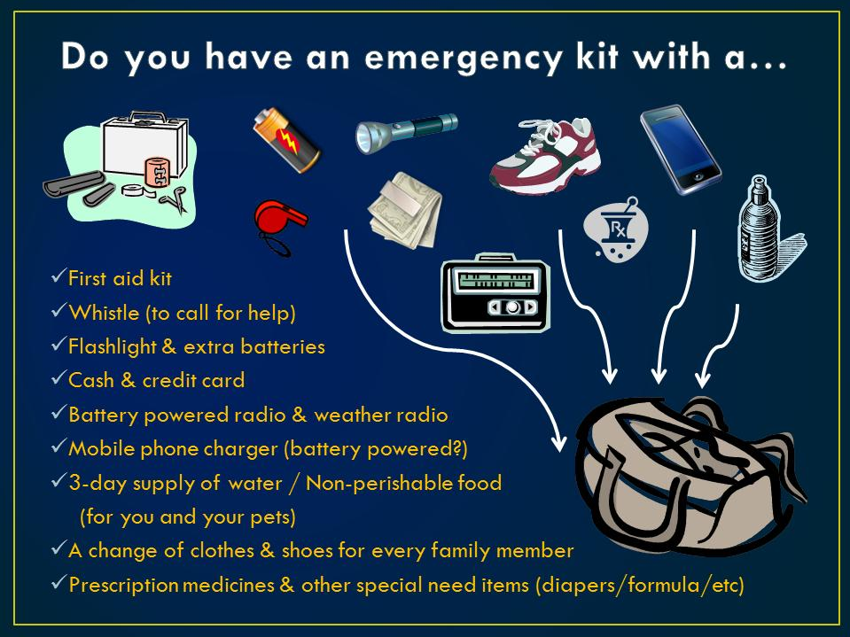
Now is the time to be prepared to act. If you wait until a tornado warning is issued for your location, it is already too late. Have a severe weather emergency kit prepared and have an action plan ready to go. Discuss the plan with your family and know what to do if you go under a warning. Check on your neighbors and the elderly. Make sure they have what they need to get through the storms and that they have a safe place to go to.
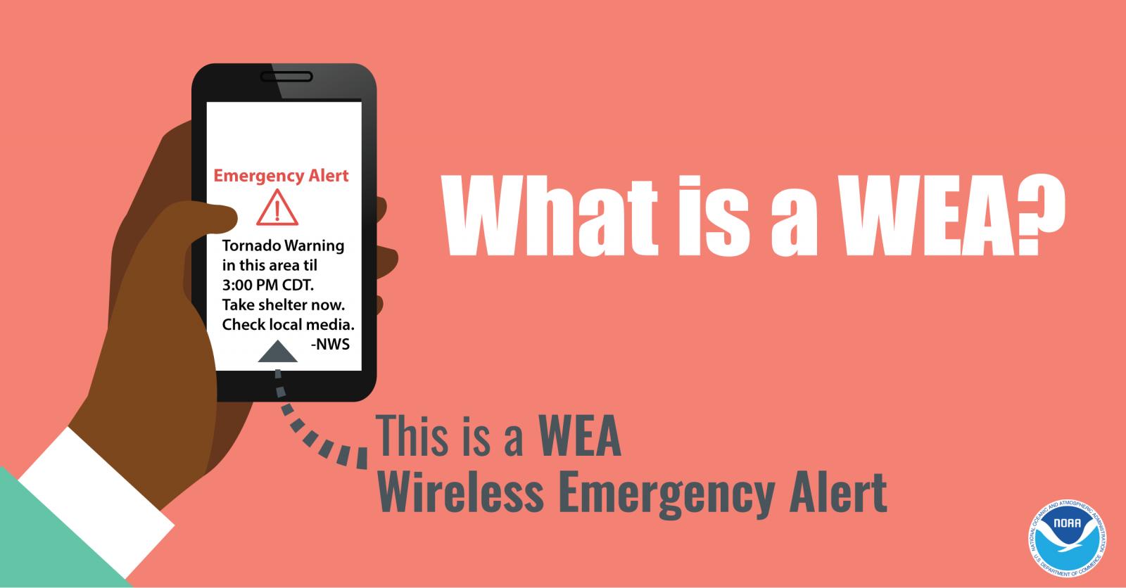
Do not rely on outdoor sirens as your method of receiving tornado warnings. Have several ways to receive warnings: a NOAA WeatherRadio, WEAs activated on your smartphone, and a trusty app like the FEMA app or MyWarn. Also, have the ABC 33/40 app downloaded on your mobile device so you can watch live coverage while in your safe place.
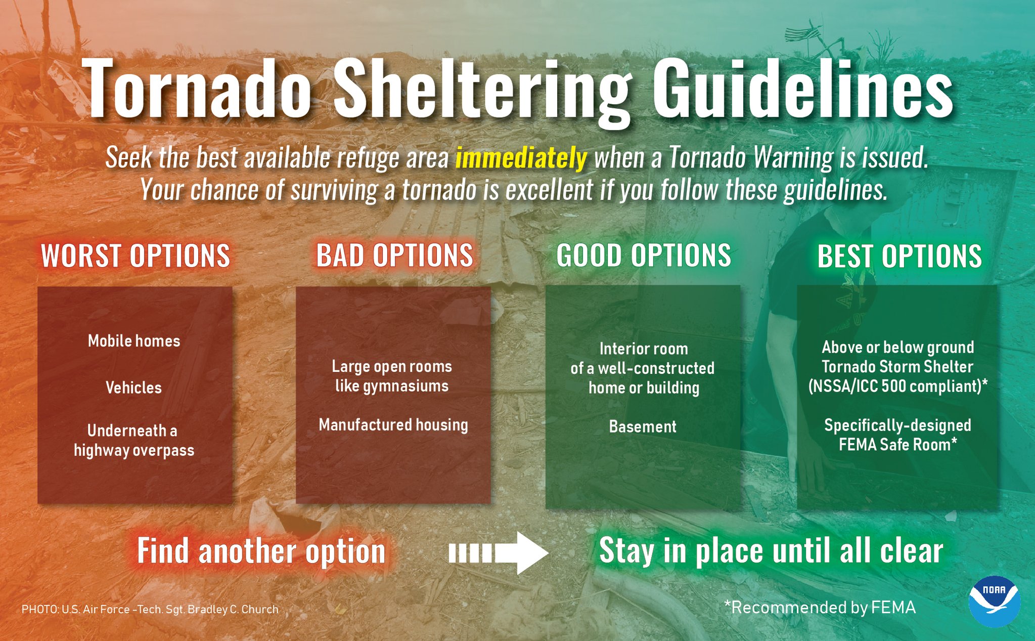
Seek the best place for shelter when a tornado warning is issued. Mobile homes, vehicles, and underneath bridges and overpasses are your worst options. Find an interior room in a well-constructed home or building, basement, storm shelter, or a safe room.
We’ll have updates throughout the day. Remember, any warnings that are issued are instantly posted to the blog.
Category: Alabama's Weather, ALL POSTS, Severe Weather
About the Author (Author Profile)
Scott Martin is an operational meteorologist, professional graphic artist, musician, husband, and father. Not only is Scott a member of the National Weather Association, but he is also the Central Alabama Chapter of the NWA president. Scott is also the co-founder of Racecast Weather, which provides forecasts for many racing series across the USA. He also supplies forecasts for the BassMaster Elite Series events including the BassMaster Classic.Subscribe
If you enjoyed this article, subscribe to receive more just like it.


