Radar Update at 7:40 p.m.: Tornado Warned Storm Over Central Mississippi; Non-Severe Storms Over Alabama at this Time
We continue to track thunderstorms across Central Alabama at this hour. They aren’t severe, but they do have some lightning, gusty winds and even have the potential for small hail.
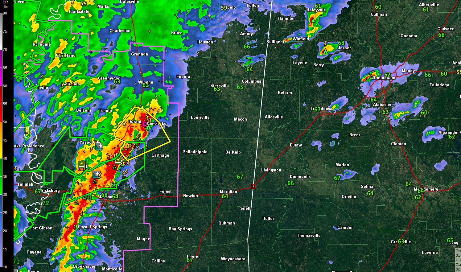
You can already see the organization on the storms as wind shear is increasing across the western half of Alabama.
The storm over Winston County is the strongest. It is centered over Double Springs, with a secondary cell near Arley. Lots of lightning in this one. The storm is out of the best instability but is in an area of high low-level helicity. There is perhaps broad rotation up high, but no threat of an imminent tornado.
The storm over southwestern Lawrence County southwest of Moulton is strong also. The NWS in Huntsville just issued a significant weather advisory on it.
The storm over northern Jefferson County weakened as it moved north. the core is sitting over I-65 just north of Warrior, in southern Blount County.
Another storm is crossing I-20 from Leeds to Moody to Pell City. Not very strong at this time
To the west, the leading edge of the intense storms now extends from Kosciusko to the Jackson Metro to Brookhaven, McComb and into southeastern Louisiana just northwest of Hammond. The line is progressing eastward at about 30 mph. At this pace, it will reach West Alabama’s Pickens and Sumter Counties between 9:30 and 11 p.m.
There is currently a severe thunderstorm warning in effect for the area around Kosciusko, and a tornado warning was just issued for that same storm. It does include Kosciusko. This storm could affect Pickens, Lamar or Marion Counties around 9:45-10 p.m.
The surface low is still back in Northeast Texas, but surface winds are SIGNIFICANTLY backed to the southeast across Alabama. This really increases the tornado threat if we get stronger updrafts as the evening goes along.
Category: Alabama's Weather, ALL POSTS
About the Author (Author Profile)
Bill Murray is the President of The Weather Factory. He is the site's official weather historian and a weekend forecaster. He also anchors the site's severe weather coverage. Bill Murray is the proud holder of National Weather Association Digital Seal #0001 @wxhistorianSubscribe
If you enjoyed this article, subscribe to receive more just like it.


