

The Tornado Warning For Southwestern Colbert County Will Expire At 12:45 AM CDT
…THE TORNADO WARNING FOR SOUTHWESTERN COLBERT COUNTY WILL EXPIRE AT
1245 AM CDT…
The storm which prompted the warning has weakened below severe
limits, and no longer appears capable of producing a tornado.
Therefore, the warning will be allowed to expire.
A Tornado Watch remains in effect until 300 AM CDT for northwestern
Alabama.
A Tornado Warning Remains In Effect Until 12:45 AM CDT For Southwestern Colbert County
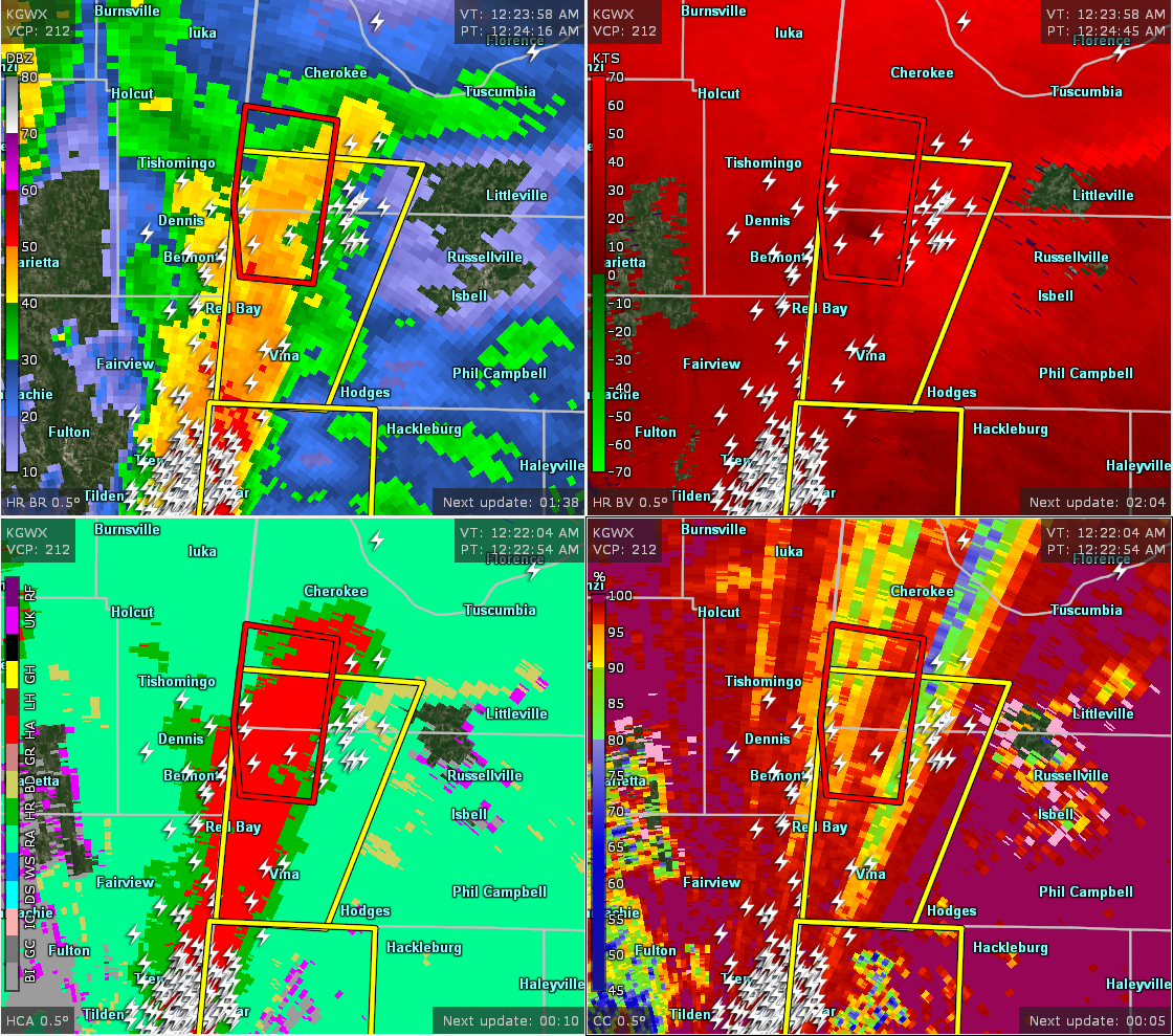
Apr 14th @ 12:35 am

…A TORNADO WARNING REMAINS IN EFFECT UNTIL 1245 AM CDT FOR SOUTHWESTERN COLBERT COUNTY… At 1233 AM CDT, a confirmed tornado was located 8 miles east of Tishomingo State Park, moving north at 45 mph.
HAZARD…Damaging tornado and quarter size hail.
SOURCE…Radar confirmed tornado.
IMPACT…Flying debris will be dangerous to those caught without shelter. Mobile homes will be damaged or destroyed. Damage to roofs, windows, and vehicles will occur. Tree damage is likely. Locations impacted include… Mynot, Maud and Allsboro.
The Tornado Warning For Northwestern Franklin County Is Cancelled
Apr 14th @ 12:34 am

…THE TORNADO WARNING FOR NORTHWESTERN FRANKLIN COUNTY IS CANCELLED…
The tornadic thunderstorm which prompted the warning has moved out of the warned area. Therefore, the warning has been cancelled. A Tornado Watch remains in effect until 300 AM CDT for northwestern Alabama. LAT…LON 3472 8812 3470 8797 3459 8799 3458 8800 3458 8811 3459 8814 TIME…MOT…LOC 0533Z 178DEG 37KT 3464 8805
A Tornado Warning Remains In Effect Until 12:45 AM CDT For Southwestern Colbert And Northwestern Franklin Counties
Apr 14th @ 12:26 am

…A TORNADO WARNING REMAINS IN EFFECT UNTIL 1245 AM CDT FOR SOUTHWESTERN COLBERT AND NORTHWESTERN FRANKLIN COUNTIES… At 1225 AM CDT, a confirmed tornado was located near Tishomingo State Park, moving north at 55 mph.
HAZARD…Damaging tornado and quarter size hail.
SOURCE…Radar confirmed tornado.
IMPACT…Flying debris will be dangerous to those caught without shelter. Mobile homes will be damaged or destroyed. Damage to roofs, windows, and vehicles will occur. Tree damage is likely. Locations impacted include… Pleasant Site, Pogo, Mynot, Maud and Allsboro.
Tornado Warning Issued For Parts Of Colbert And Franklin Counties Until 12:45AM
Apr 14th @ 12:23 am

The National Weather Service in Huntsville Alabama has issued a
* Tornado Warning for…
Southwestern Colbert County in northwestern Alabama…
Northwestern Franklin County in northwestern Alabama…
* Until 1245 AM CDT.
* At 1222 AM CDT, a severe thunderstorm capable of producing a tornado was located 7 miles northeast of Red Bay, moving north at 50 mph.
HAZARD…Tornado.
SOURCE…Radar indicated rotation.
IMPACT…Flying debris will be dangerous to those caught without shelter. Mobile homes will be damaged or destroyed.
Damage to roofs, windows, and vehicles will occur. Tree damage is likely.
* Locations impacted include…
Pleasant Site, Pogo, Mynot, Maud and Allsboro.
Category: ALL POSTS
About the Author (Author Profile)
Subscribe
If you enjoyed this article, subscribe to receive more just like it.


