

The Severe Thunderstorm Warning For Northeastern Cullman And Southeastern Morgan Counties Will Expire At 4:15 AM CDT
…THE SEVERE THUNDERSTORM WARNING FOR NORTHEASTERN CULLMAN AND
SOUTHEASTERN MORGAN COUNTIES WILL EXPIRE AT 415 AM CDT…
The storms which prompted the warning have weakened below severe
limits, and have exited Cullman and Morgan counties. Therefore, the
warning will be allowed to expire.
A Tornado Watch remains in effect until 600 AM CDT for north central
and northeastern Alabama. A Tornado Watch also remains in effect
until 900 AM CDT for northeastern Alabama.
A Severe Thunderstorm Warning Remains In Effect Until 4:15 AM CDT For Northeastern Cullman And Southeastern Morgan Counties
Apr 14th @ 4:00 am

…A SEVERE THUNDERSTORM WARNING REMAINS IN EFFECT UNTIL 415 AM CDT FOR NORTHEASTERN CULLMAN AND SOUTHEASTERN MORGAN COUNTIES… At 400 AM CDT, severe thunderstorms were located along a line extending from near Morgan City to near Holly Pond, moving east at 35 mph.
HAZARD…60 mph wind gusts and quarter size hail.
SOURCE…Radar indicated.
IMPACT…Hail damage to vehicles is expected. Expect wind damage to roofs, siding, and trees. Locations impacted include… Cullman, Holly Pond, Morgan City, Baileyton, Eva, Walter, Laceys Spring, Valhermoso Springs, Ryan Crossroads and Joppa.
A Severe Thunderstorm Warning Remains In Effect Until 4:15 AM CDT For Eastern Cullman And Southeastern Morgan Counties
Apr 14th @ 3:51 am

…A SEVERE THUNDERSTORM WARNING REMAINS IN EFFECT UNTIL 415 AM CDT FOR EASTERN CULLMAN AND SOUTHEASTERN MORGAN COUNTIES… At 350 AM CDT, severe thunderstorms were located along a line extending from near Morgan City to near Dodge City, moving east at 25 mph.
HAZARD…60 mph wind gusts and quarter size hail.
SOURCE…Radar indicated.
IMPACT…Hail damage to vehicles is expected. Expect wind damage to roofs, siding, and trees. Locations impacted include… Cullman, Hanceville, Priceville, Good Hope, Falkville, Holly Pond, Dodge City, Triana, Morgan City and Baldwin.
Severe Thunderstorm Warning Issued For Parts Of Cullman And Morgan Counties Until 4:15AM
Apr 14th @ 3:27 am
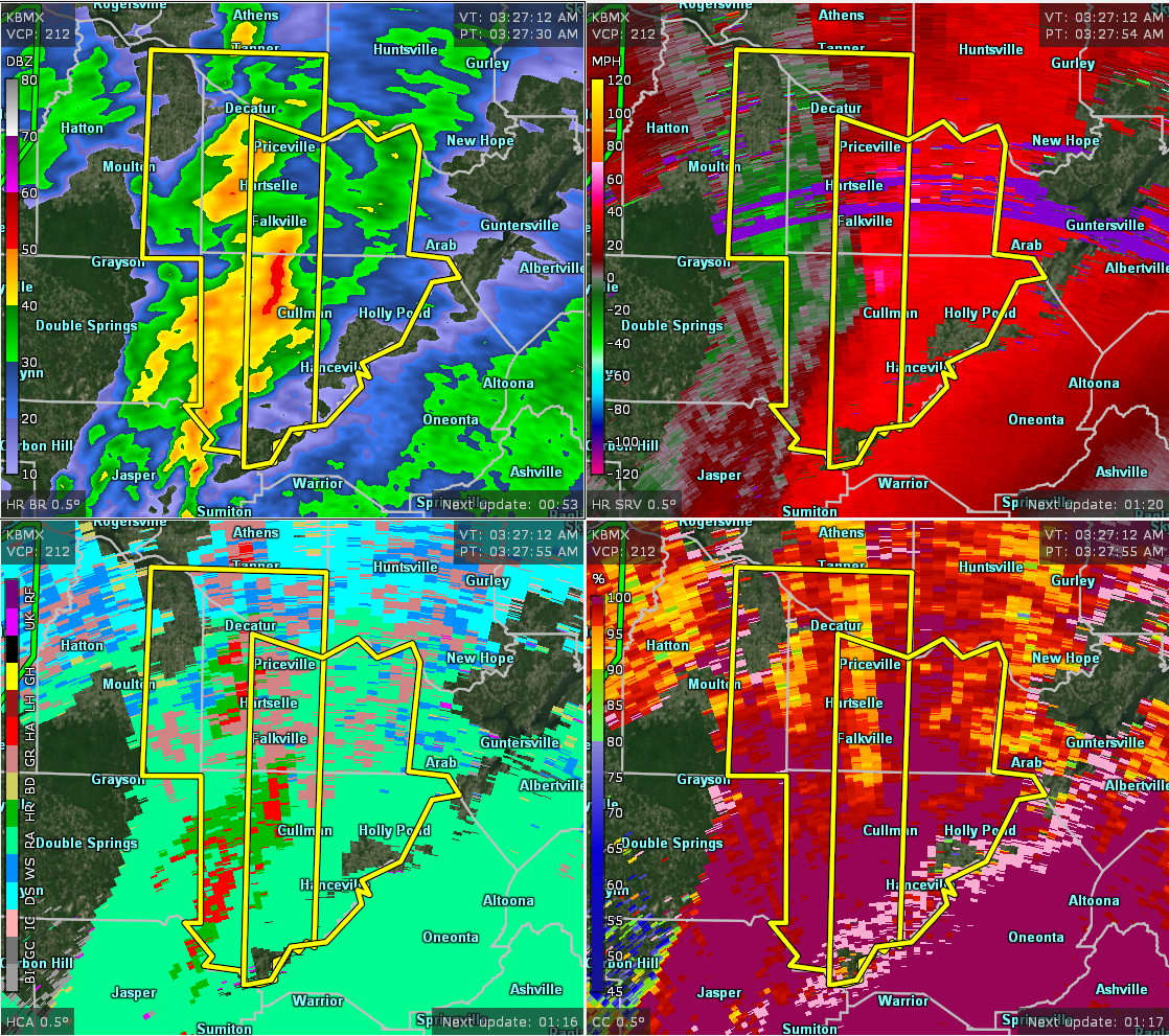

The National Weather Service in Huntsville Alabama has issued a
* Severe Thunderstorm Warning for…
Cullman County in north central Alabama…
Morgan County in north central Alabama…
* Until 415 AM CDT.
* At 326 AM CDT, severe thunderstorms were located along a line extending from Priceville to Arkadelphia, moving east at 30 mph.
HAZARD…60 mph wind gusts and quarter size hail.
SOURCE…Radar indicated.
IMPACT…Hail damage to vehicles is expected. Expect wind damage to roofs, siding, and trees.
* Locations impacted include…
Decatur, Cullman, Hartselle, Hanceville, Priceville, Good Hope, Falkville, Holly Pond, Dodge City and Triana.
Category: ALL POSTS
About the Author (Author Profile)
Subscribe
If you enjoyed this article, subscribe to receive more just like it.


