A Tornado Warning Remains In Effect Until 8:15 AM CDT For East Central Bullock And Northeastern Barbour Counties

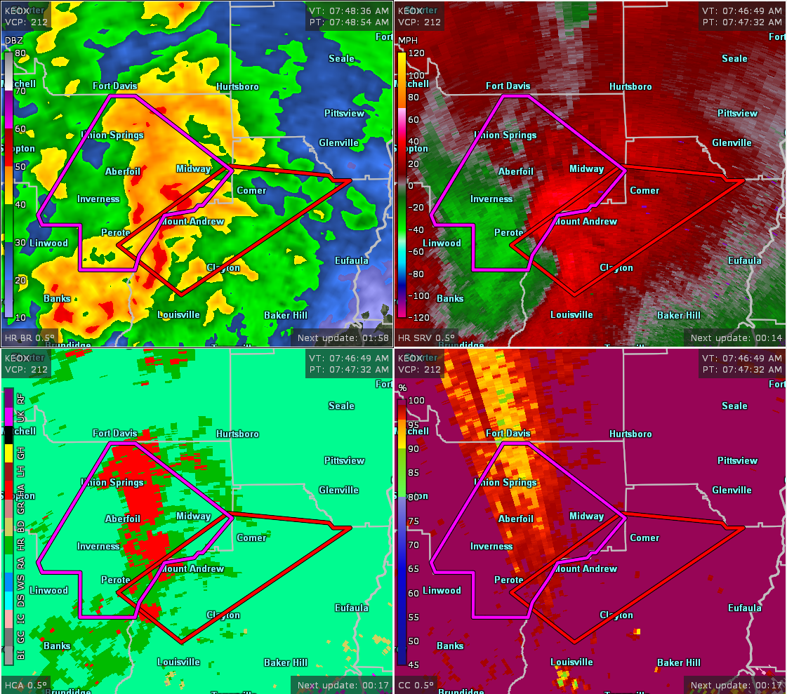
…A TORNADO WARNING REMAINS IN EFFECT UNTIL 815 AM CDT FOR EAST CENTRAL BULLOCK AND NORTHEASTERN BARBOUR COUNTIES… At 800 AM CDT, a severe thunderstorm capable of producing a tornado was located over Barbour County Public Lake Dam, or near Midway, moving northeast at 45 mph.
HAZARD…Tornado.
SOURCE…Radar indicated rotation.
IMPACT…Flying debris will be dangerous to those caught without shelter. Mobile homes will be damaged or destroyed. Damage to roofs, windows, and vehicles will occur. Tree damage is likely. Locations impacted include… Comer, Hawkinsville, Barbour County Public Lake Dam, Spring Hill, Mount Andrew and Batesville.
Tornado Warning Issued For Parts Of Barbour And Bullock Counties Until 8:15AM
Apr 14th @ 7:48 am

The National Weather Service in Birmingham has issued a
* Tornado Warning for…
Southeastern Bullock County in southeastern Alabama…
Northern Barbour County in southeastern Alabama…
* Until 815 AM CDT.
* At 748 AM CDT, a severe thunderstorm capable of producing a tornado was located near Boot Hill, or 11 miles south of Midway, moving northeast at 40 mph.
HAZARD…Tornado.
SOURCE…Radar indicated rotation.
IMPACT…Flying debris will be dangerous to those caught without shelter. Mobile homes will be damaged or destroyed.
Damage to roofs, windows, and vehicles will occur. Tree damage is likely.
* Locations impacted include…
Clayton, Hawkinsville, Spring Hill, Comer, Barbour County Public
Lake Dam, Batesville, Clayton Municipal Airport and Mount Andrew.
Category: ALL POSTS
About the Author (Author Profile)
Subscribe
If you enjoyed this article, subscribe to receive more just like it.


