

The Severe Thunderstorm Warning For Northeastern Perry And Eastern Bibb Counties Will Expire At 7:30 PM CDT
…THE SEVERE THUNDERSTORM WARNING FOR NORTHEASTERN PERRY AND EASTERN
BIBB COUNTIES WILL EXPIRE AT 730 PM CDT…
The storms which prompted the warning have moved out of the area.
Therefore, the warning will be allowed to expire.
A Tornado Watch remains in effect until 1100 PM CDT for central,
south central and west central Alabama.
A Severe Thunderstorm Warning Remains In Effect Until 7:30 PM CDT For Northeastern Perry And Eastern Bibb Counties
Apr 18th @ 7:15 pm

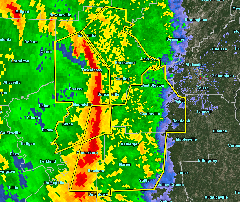
…A SEVERE THUNDERSTORM WARNING REMAINS IN EFFECT UNTIL 730 PM CDT FOR NORTHEASTERN PERRY AND EASTERN BIBB COUNTIES… At 715 PM CDT, severe thunderstorms were located along a line extending from Maylene to Valley Grande, moving east at 45 mph.
HAZARD…60 mph wind gusts.
SOURCE…Radar indicated.
IMPACT…Expect damage to roofs, siding, and trees. Locations impacted include… Centreville, West Blocton, Lawley, Ashby, Brierfield Ironworks Park, West Centreville, Talladega National Forest, Randolph, Trio, Six Mile, Bibb County Airport, Suttle, Oakmulgee and Hebron.
A Severe Thunderstorm Warning Remains In Effect Until 7:30 PM CDT For Perry And Bibb Counties
Apr 18th @ 7:04 pm

…A SEVERE THUNDERSTORM WARNING REMAINS IN EFFECT UNTIL 730 PM CDT FOR PERRY AND BIBB COUNTIES… At 704 PM CDT, severe thunderstorms were located along a line extending from 6 miles southeast of Tannehill Ironworks State Park to near Potter Station, moving east at 45 mph.
HAZARD…60 mph wind gusts.
SOURCE…Radar indicated.
IMPACT…Expect damage to roofs, siding, and trees. Locations impacted include… Brent, Marion, Centreville, Vance, Woodstock, West Blocton, Vaiden, West Centreville, Heiberger, Lawley, Ashby, Brierfield Ironworks Park, Talladega National Forest, Eoline, North Bibb, Randolph, Radford, Six Mile, Bibb County Airport and Green Pond.
A Severe Thunderstorm Warning Remains In Effect Until 7:30 PM CDT For Perry And Bibb Counties
Apr 18th @ 6:47 pm

…A SEVERE THUNDERSTORM WARNING REMAINS IN EFFECT UNTIL 730 PM CDT FOR PERRY AND BIBB COUNTIES… At 647 PM CDT, severe thunderstorms were located along a line extending from near West Blocton to near Marion Junction, moving east at 40 mph.
HAZARD…70 mph wind gusts.
SOURCE…Radar indicated.
IMPACT…Expect considerable tree damage. Damage is likely to mobile homes, roofs, and outbuildings. Locations impacted include… Brent, Marion, Centreville, Uniontown, Vance, Woodstock, West Blocton, Newbern, Vaiden, West Centreville, Heiberger, Lawley, Ashby, Brierfield Ironworks Park, Low Gap, Mertz, Talladega National Forest, Eoline, North Bibb and Randolph.
A Severe Thunderstorm Warning Remains In Effect Until 7:30 PM CDT For Perry And Bibb Counties
Apr 18th @ 6:34 pm

…A SEVERE THUNDERSTORM WARNING REMAINS IN EFFECT UNTIL 730 PM CDT FOR PERRY AND BIBB COUNTIES… At 632 PM CDT, severe thunderstorms were located along a line extending from near Coaling to near Vaiden, moving east at 40 mph.
HAZARD…70 mph wind gusts.
SOURCE…Radar indicated.
IMPACT…Expect considerable tree damage. Damage is likely to mobile homes, roofs, and outbuildings. Locations impacted include… Brent, Marion, Centreville, Uniontown, Vance, Woodstock, West Blocton, Newbern, Vaiden, West Centreville, Heiberger, Lawley, Ashby, Brierfield Ironworks Park, Low Gap, Mertz, Talladega National Forest, Eoline, North Bibb and Randolph.
The Severe Thunderstorm Warning For Eastern Hale County Is Cancelled
Apr 18th @ 6:33 pm

…THE SEVERE THUNDERSTORM WARNING FOR EASTERN HALE COUNTY IS CANCELLED…
The storms which prompted the warning have moved out of the warned area. Therefore, the warning has been cancelled. A Tornado Watch remains in effect until 1100 PM CDT for central, south central and west central Alabama. LAT…LON 3266 8747 3283 8747 3284 8742 3300 8742 3301 8732 3313 8728 3313 8720 3322 8717 3325 8703 3317 8703 3306 8693 3305 8688 3284 8688 3284 8702 3260 8704 3249 8711 3248 8742 3245 8742 3244 8752 3265 8753 TIME…MOT…LOC 2332Z 259DEG 36KT 3313 8733 3250 8745
Severe Thunderstorm Warning Issued For Parts Of Bibb, Hale, And Perry Counties Until 7:30PM
Apr 18th @ 6:20 pm

The National Weather Service in Birmingham has issued a
* Severe Thunderstorm Warning for…
Perry County in central Alabama…
Eastern Hale County in west central Alabama…
Bibb County in central Alabama…
* Until 730 PM CDT.
* At 619 PM CDT, severe thunderstorms were located along a line extending from near Shelton State Community College to near
Faunsdale, moving east at 40 mph.
HAZARD…60 mph wind gusts.
SOURCE…Radar indicated.
IMPACT…Expect damage to roofs, siding, and trees.
* Locations impacted include…
Brent, Marion, Centreville, Greensboro, Uniontown, Vance, Woodstock, West Blocton, Newbern, Vaiden, West Centreville, Heiberger, Lawley, Ashby, Greensboro Municipal Airport, Brierfield
Ironworks Park, Low Gap, Mertz, Talladega National Forest and
Eoline.
Category: ALL POSTS
About the Author (Author Profile)
Subscribe
If you enjoyed this article, subscribe to receive more just like it.


