Midday Nowcast: Welcome to May
As we roll into the new month, our moisture levels are increasing and we are seeing more clouds in the Alabama sky today. It remains a very warm day as well and all of us will once again be in the mid 80s for afternoon highs.
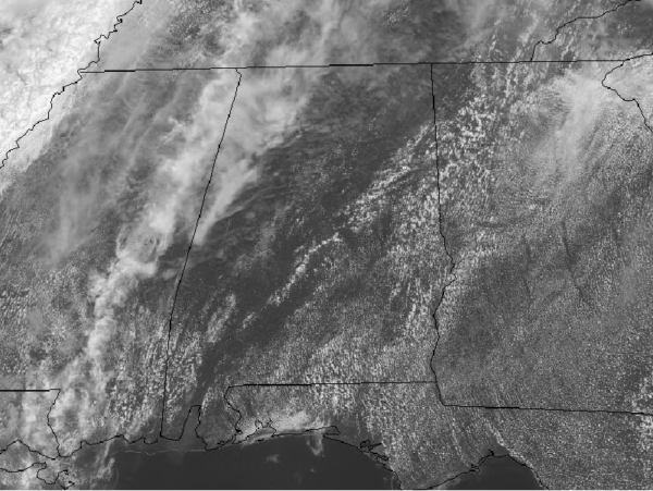
As of midday, we are dry across the state, but we are expecting a few widely isolated showers across the state through the afternoon and evening hours, with even the chance for a thunderstorm in the mix as well. Any convection today will wind down after sunset and we should more clouds in the sky tonight, with lows in the 60s.
For tomorrow, more of the same is expected with a mix of sun and clouds, highs in the mid 80s, and the isolated chance for a passing shower, mainly during the afternoon and evening hours. Like today, most locations will be staying dry.
USA BRIEF: Severe weather will be possible across a broad area across the South and Central Plains, and Lower and Middle Mississippi Valley today.
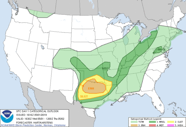
Very large hail will be possible for a portion of west-central Texas, otherwise, damaging winds, hail, and heavy rain will be the primary threats.
TROPICAL MISCHIEF?: We are still a month away from the official start to the Atlantic hurricane season, but as of this morning, a tropical disturbance has formed over the Bahama.
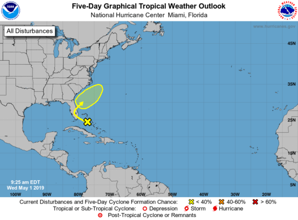
A trough of low pressure located over the northwestern Bahamas is producing disorganized shower and thunderstorm activity. Little development is expected during the next couple of days as the system moves generally northwestward toward the Florida Peninsula. Subsequently, some slow development is possible as the disturbance turns northeastward and moves over the western Atlantic. Regardless of development, locally heavy rains are possible over portions of the Bahamas and the Florida Peninsula during the next couple of days. Formation chance through 5 days…low…20 percent.
BEACH FORECAST CENTER: Get the latest weather and rip current forecasts for the beaches from Fort Morgan to Panama City on our Beach Forecast Center page. There, you can select the forecast of the region that you are interested in visiting.
WORLD TEMPERATURE EXTREMES: Over the last 24 hours, the highest observation outside the U.S. was 117.0F at Banda, India. The lowest observation was -99.2F at Concordia, Antarctica.
CONTIGUOUS TEMPERATURE EXTREMES: The highest observation was 101F at Rio Grande Village, TX. The lowest observation was 4F at Yellow Mule, MT.
WEATHER ON THIS DATE IN 1988: Strong southerly winds ahead of a cold front crossing the Rocky Mountain Region gusted to 90 mph at Lamar CO. High winds created blinding dust storms in eastern Colorado, closing roads around Limon.
Category: Alabama's Weather, ALL POSTS
About the Author (Author Profile)
Macon, Georgia Television Chief Meteorologist, Birmingham native, and long time Contributor on AlabamaWX. Stormchaser. I did not choose Weather, it chose Me. College Football Fanatic. @Ryan_StinnetSubscribe
If you enjoyed this article, subscribe to receive more just like it.


