Rather Nice At Midday; Plus, We Take A Look At Saturday’s Severe Threat
HOW’S THE FIRST FRIDAY OF MAY?
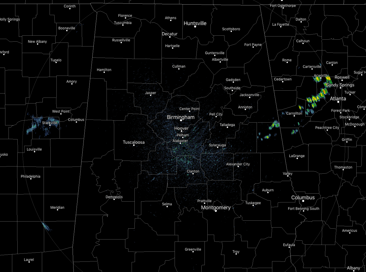
As of 11:45 am, we have a few showers remaining in the extreme eastern parts of Central Alabama, mainly over the northern half of Randolph County. These are moving off to the east and should be in Georgia within the next 60-90 minutes. The rest of the area is dry at this point with a decent amount of sunshine. Temperatures are currently in the mid-70s to the mid-80s across the area.
We’ll have a small chance of a few isolated showers and thunderstorms across the area with the chances being just a little higher in the southern parts of the area south of a line from Demopolis to Clanton to Alexander City. Skies will be mostly clear to partly cloudy where rain is not occurring and highs top out in the 80s. For tonight, we’ll have a small chance of an isolated shower or storm during the evening and into the late night hours, but more scattered to numerous storms are expected to move across the northern parts of the area during the overnight and pre-dawn hours. Lows will be down in the mid to upper 60s.
POTENTIAL FOR STORNG TO SEVERE STORMS ON SATURDAY
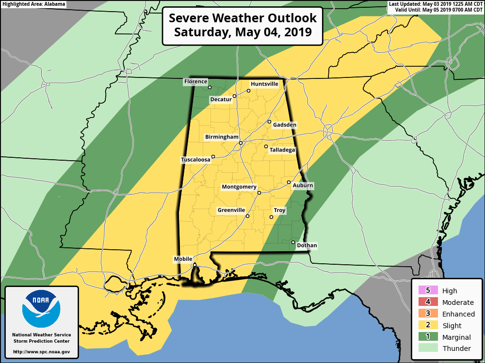
As of 11:30 am today, the Storm Prediction Center continues to have nearly all of the Central Alabama area in a Slight Risk (level 2 of 5) for severe storms during the day on Saturday, with the extreme northwest corner and the extreme southeast corner of the area in a Marginal Risk (level 1 of 5).
At this point, the main window for the potential of severe weather will be from roughly 12:00 pm Saturday through midnight. The main threat will come from damaging thunderstorm wind gusts up to 60 MPH with a smaller threat of quarter-size hail. While the tornado threat is not zero, the flow will be unidirectional so it would be difficult for a tornado to form, but not impossible.
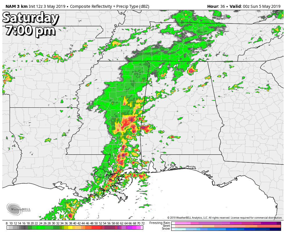
The latest run of the high-resolution NAM shows a line of storms moving in during the evening hours, entering the western portions of Central Alabama around 7:00 pm, making it into the Birmingham metropolitan area and the middle parts of the area around 10:00 pm, then beginning to exit the state and moving into Georgia around 1:00 am Sunday.
There may be some scattered activity that forms throughout the afternoon and early evening hours before the system moves in which could potentially become strong to severe, but the main threat will come with the line of storms.
Two limiting factors… The NAM is also showing the potential for showers and storms to move across the northern half of the area during the morning hours. If enough rain falls and cools the surface enough, that may keep locations north of I-20 more stable. Also, if any stronger storms form along the Gulf Coast, that could stop much of the energy from moving up into Central Alabama. At this point, we’ll have to wait and see on that.
While this is a lower-end threat to Central Alabama, it is still the Spring Severe Weather Season for the area. Be prepared and have your kits and safe place ready just in case you go under a warning. Treat a severe thunderstorm warning as a tornado warning. Deaths and injuries can occur in severe thunderstorms. I’ll have updates throughout the day on Saturday starting with the Weather Xtreme Video out by 8:00 am.
BEACH FORECAST CENTER
Get the latest weather and rip current forecasts for the beaches from Fort Morgan to Panama City on our Beach Forecast Center page. There, you can select the forecast of the region that you are interested in.
PGA CHAMPIONS TOUR RETURNS TO GREYSTONE FOR THE REGIONS TRADITION
The Regions Tradition will be May 8-12 at the beautiful Greystone Golf & Country Club! Make plans to attend one of the majors of the PGA Champions Tour! You can see legendary golfers Miguel Ángel Jiménez, Fred Couples, John Daly, Vijay Singh, and more tee it off with Nick Saban, Gus Malzahn, Bo Jackson, Condoleezza Rice, and other celebrities in the NCR Pro-AM. Juniors 18 & under are admitted free with a ticketed adult, and five-day grounds tickets are $100. Single day grounds tickets are $25. GET YOUR TICKETS HERE!!!
E-FORECAST
Get the Alabama Wx Weather Blog’s Seven-Day Forecast delivered directly to your inbox by email twice daily. It is the most detailed weather forecast available in Central Alabama. Subscribe here… It’s free!
CONNECT WITH THE BLOG ON SOCIAL MEDIA
You can find the AlabamaWx Weather Blog on the major social media networks:
Facebook
Twitter
Instagram
Category: Alabama's Weather, ALL POSTS, Severe Weather
About the Author (Author Profile)
Scott Martin is an operational meteorologist, professional graphic artist, musician, husband, and father. Not only is Scott a member of the National Weather Association, but he is also the Central Alabama Chapter of the NWA president. Scott is also the co-founder of Racecast Weather, which provides forecasts for many racing series across the USA. He also supplies forecasts for the BassMaster Elite Series events including the BassMaster Classic.Subscribe
If you enjoyed this article, subscribe to receive more just like it.


