Severe T-Storm Warning For Parts Of Marengo County Is Canceled
UPDATE 2:03 PM
The storms in Marengo County has now moved into parts of Perry County and is no longer severe.
ORIGINAL POST
BULLETIN – IMMEDIATE BROADCAST REQUESTED
SEVERE THUNDERSTORM WARNING
NATIONAL WEATHER SERVICE BIRMINGHAM AL
138 PM CDT THU MAY 9 2019
THE NATIONAL WEATHER SERVICE IN BIRMINGHAM HAS ISSUED A
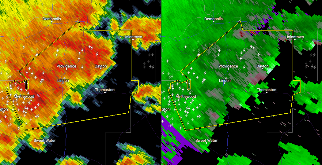
* SEVERE THUNDERSTORM WARNING FOR…
CENTRAL MARENGO COUNTY IN SOUTHWESTERN ALABAMA…
* UNTIL 230 PM CDT.
* AT 138 PM CDT, A SEVERE THUNDERSTORM WAS LOCATED NEAR MYRTLEWOOD,
OR NEAR LINDEN, MOVING EAST AT 30 MPH.
HAZARD…60 MPH WIND GUSTS AND QUARTER SIZE HAIL.
SOURCE…RADAR INDICATED.
IMPACT…HAIL DAMAGE TO VEHICLES IS EXPECTED. EXPECT WIND DAMAGE
TO ROOFS, SIDING, AND TREES.
* LOCATIONS IMPACTED INCLUDE…
LINDEN, UNIONTOWN, JEFFERSON, THOMASTON, MYRTLEWOOD, FAUNSDALE,
DAYTON, FREDDIE JONES FIELD, PIN HOOK, CONSUL, CHICKASAW STATE
PARK, HALF ACRE, OLD SPRING HILL, OCTAGON, CALVARY AND OAKCHIA.
PRECAUTIONARY/PREPAREDNESS ACTIONS…
FOR YOUR PROTECTION MOVE TO AN INTERIOR ROOM ON THE LOWEST FLOOR OF A
BUILDING.
Category: ALL POSTS
About the Author (Author Profile)
Scott Martin is an operational meteorologist, professional graphic artist, musician, husband, and father. Not only is Scott a member of the National Weather Association, but he is also the Central Alabama Chapter of the NWA president. Scott is also the co-founder of Racecast Weather, which provides forecasts for many racing series across the USA. He also supplies forecasts for the BassMaster Elite Series events including the BassMaster Classic.Subscribe
If you enjoyed this article, subscribe to receive more just like it.


