Some Showers Out There At Midday, A Few Stronger Storms Possible This Afternoon
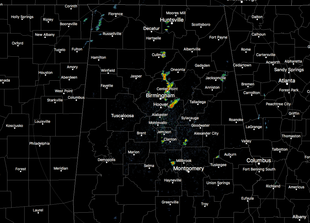
We have a few isolated showers that have popped up on radar as we have made it to 12:40 pm on this early Wednesday afternoon. These were in a broken line stretching from just east of Cullman, south to Pinson and Center Point, then coming to an end just to the north-northeast of Chelsea. None of these are strong at this point and only a few rumbles of thunder have been reported in the last few minutes with that cell close to Chelsea. There are a few lighter isolated showers along and just west of I-65 approaching Jemison and Clanton. These are all moving to the northeast.
Temperatures at this time were in the mid-70s to the upper 80s across the area from north to south. It’s 75 degrees in Haleyville as the cool spot while it’s 88 degrees down in Troy as the warm spot. Birmingham was at 81 degrees.
With the main heating of the day and the proximity of a center of low pressure over the extreme southeastern parts of the state, we will see showers and thunderstorms develop throughout the afternoon hours mainly east of the I-65 corridor, with the higher rain chances being closer to the AL/GA state line. One or two of these storms may ramp up to become strong, so we need to watch these throughout the afternoon. Highs will be in the 80s throughout the area with the warmest temperatures occurring in the west and southwestern parts of the area.
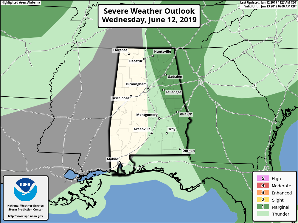
SPC has a Marginal Risk for severe storms up for locations east of a line from Ardmore (Madison Co.) to Oneonta (Blount Co.) to Goodwater (Coosa Co.) to Clayton (Barbour Co.). The main threats will be from isolated damaging wind gusts up to 60 MPH and isolated hail up to quarter size in diameter. The main timing for stronger storms will be from roughly 1:00 pm through 7:00 pm tonight.
All of the rain and thunderstorm activity should come to an end by or just after sunset this evening, then skies will be clearing out for the rest of the late night and overnight hours. Lows will be in the upper 50s to the mid-60s across the area from northwest to southeast.
Thursday’s weather will be like stepping back into early May as we’ll have lower humidity levels and much cooler temperatures than what we have seen over the past month or so. Skies will be mainly sunny throughout the area with afternoon highs reaching the upper 70s to the mid-80s across the area from northwest to southeast. Clear skies and a cool evening on Thursday night with lows dipping into the lower 50s to the lower 60s.
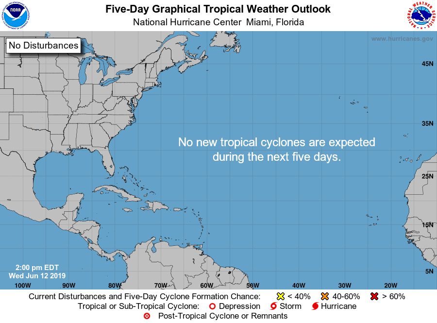
A QUICK LOOK AT THE TROPICS
No tropical activity of concern at this point and no new tropical cyclones are expected throughout the next five days.
BEACH FORECAST CENTER
Get the latest weather and rip current forecasts for the beaches from Fort Morgan to Panama City on our Beach Forecast Center page. There, you can select the forecast of the region that you are interested in.
ON THIS DAY IN WEATHER HISTORY
1989 – Thunderstorms produced severe weather from Tennessee Valley to the Central Appalachians in the afternoon and evening, and produced severe weather in Oklahoma and Texas during the evening and night. Thunderstorms spawned ten tornadoes, and there were 164 reports of large hail and damaging winds. Thunderstorms produced wind gusts to 100 mph at Amarillo, TX, and wind gusts to 110 mph at Denton TX. Hail three inches in diameter was reported at Tucumcari NM.
Category: Alabama's Weather, ALL POSTS
About the Author (Author Profile)
Scott Martin is an operational meteorologist, professional graphic artist, musician, husband, and father. Not only is Scott a member of the National Weather Association, but he is also the Central Alabama Chapter of the NWA president. Scott is also the co-founder of Racecast Weather, which provides forecasts for many racing series across the USA. He also supplies forecasts for the BassMaster Elite Series events including the BassMaster Classic.Subscribe
If you enjoyed this article, subscribe to receive more just like it.


