Nothing On Radar At 11:00 AM, But It’s Already A Hot One Across Central Alabama
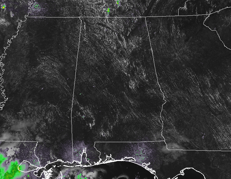
At 11:00 am on this fine but hot Tuesday morning, we have mostly clear skies across Central Alabama with no rain showing up on radar at this point. It may stay that way for a couple of more hours, but a few isolated showers and thunderstorms are expected to pop up somewhere across the area during the afternoon to early evening hours. Clouds will build somewhat during the main heating of the day making it partly cloudy by the late afternoon hours. Afternoon highs will be up in the lower to mid-90s for much of the area, with some locations in the southern parts of the area hitting the upper 90s. Heat index values will be up in the 100-105 degree range today, so be sure to stay hydrated while outdoors and find some shade to cool off in. Tonight will be very muggy underneath partly cloudy skies, but all rainfall should have dissipated by sunset. Lows will be in the lower to mid-70s across the area.
No real change in the forecast for Wednesday even though rain chances for the afternoon to early evening hours will be a little higher. We’ll still remain hot and humid with a chance of scattered showers and thunderstorms and highs reaching the upper 80s to the upper 90s across the area from northwest to southeast. Rain chances will be highest in the western half of Central Alabama. Heat index values will be right back up in the 100-105 degree range throughout much of the area with the exception of the far northwestern parts of the area.
Taking a quick peek at Thursday, also known as Independence Day… Central Alabama remains hot and humid with the standard chance of scattered afternoon showers and thunderstorms. Highs will top out in the lower to mid-90s across the area with heat index values in the 100-105 degree range. Rain chances will diminish somewhat for the evening hours for any fireworks, but there will still be a very small chance of a passing shower or storm. Temperatures will be the lower to mid-80s across the area at 8:00 pm and eventually dropping into the lower to mid-70s for the overnight lows.
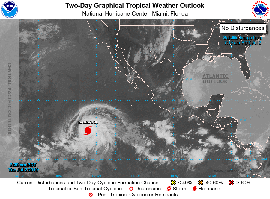
THE TROPICS: The Atlantic Basin remains very quiet at this point and no new tropical cyclones are expected to develop within the next five days. However… We have a major hurricane out over the Eastern North Pacific Ocean. Its name is Barbara and is packing maximum winds at 130 MPH. She is heading out in the general direction of the Hawaiian Islands but is expected to weaken greatly to a tropical storm by Saturday morning.
ON THIS DAY IN WEATHER HISTORY: 1833 – An unusually large New England tornado, one half to three quarters of a mile wide, went from Salem Pond to Norton Pond, VT, and then into Canada. It prostrated nearly everything in its path.
1843 – An alligator reportedly fell from the sky onto Anson Street in Charleston, SC, during a thunderstorm.
1989 – Thunderstorms produced severe weather in the south-central U.S., with 158 reports of large hail and damaging winds through the day. Evening thunderstorms in northeastern Texas produced softball size hail which caused more than five million dollars damage at Allen, and wind gusts to 90 mph at Dallas, which injured eight persons and caused seven million dollars damage. Winnfield LA reported 29.52 inches of rain in six days, for a total of 62.50 inches for the first six months of the year. Midland, TX, reported an all-time record high of 112 degrees.
BEACH FORECAST CENTER: Get the latest weather and rip current forecasts for the beaches from Fort Morgan to Panama City on our Beach Forecast Center page. There, you can select the forecast of the region that you are interested in.
ALREADY OFF TO A HOT START IN 2019! ADVERTISE WITH THE BLOG!: We have enjoyed nearly 11 MILLION page views on AlabamaWx.com so far in 2019! Don’t miss out! We can customize a creative, flexible and affordable package that will suit your organization’s needs. Contact Bill Murray at (205) 687-0782.
E-FORECAST: Get the Alabama Wx Weather Blog’s Seven-Day Forecast delivered directly to your inbox by email twice daily. It is the most detailed weather forecast available in Central Alabama. Subscribe here… It’s free!
CONNECT WITH THE BLOG ON SOCIAL MEDIA: You can find the AlabamaWx Weather Blog on the major social media networks:
Facebook
Twitter
Instagram
WEATHERBRAINS: Don’t forget you can listen to our weekly 90 minute netcast anytime on the web at WeatherBrains.com or on iTunes, Stitcher, or Spotify. This is the show all about weather featuring many familiar voices, including the meteorologists at ABC 33/40.
Category: Alabama's Weather, ALL POSTS
About the Author (Author Profile)
Scott Martin is an operational meteorologist, professional graphic artist, musician, husband, and father. Not only is Scott a member of the National Weather Association, but he is also the Central Alabama Chapter of the NWA president. Scott is also the co-founder of Racecast Weather, which provides forecasts for many racing series across the USA. He also supplies forecasts for the BassMaster Elite Series events including the BassMaster Classic.Subscribe
If you enjoyed this article, subscribe to receive more just like it.


