Scattered Storms In The East, Dry In The West At Midday
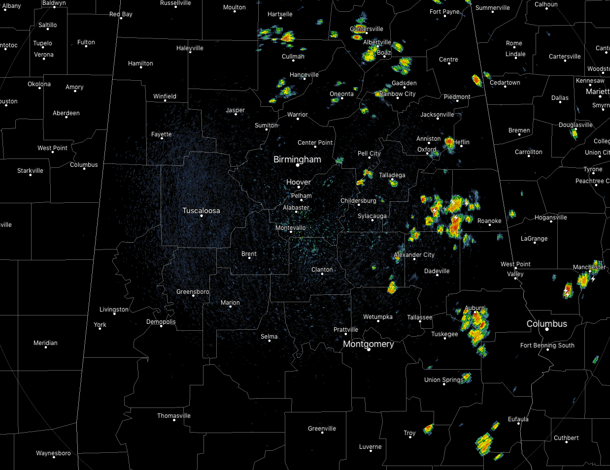
AT 11:45 AM: We already have a good bit of scattered shower and thunderstorm activity over the eastern half of the area while the western half is rather quiet. This will probably change as more showers and storms will develop through the afternoon. Temperatures are currently in the upper 80s to the lower 90s across the area with Troy leading the way at 93 degrees. Birmingham was at 90 degrees while the cool spots were Auburn and Haleyville at 88 degrees.
THE REST OF YOUR FRIDAY: It will continue to be a hot and humid day across Central Alabama. Skies will range from mostly clear to partly cloudy across the area through the rest of the morning, but more clouds will build with the heating of the day. We can expect scattered showers and thunderstorms to develop during the afternoon hours with the greater coverage across the eastern half of the area. Highs will top out in the lower to mid 90s across the area with heat index values reaching the 100-105 degree range.
For this evening and into the late night hours, we’ll continue to see scattered to numerous showers and thunderstorms over the eastern half of the area while activity will be isolated to scattered in coverage in the west. Activity will start to diminish as we lose the heating andmost, if not all, showers and storms should be gone by midnight. Overnight lows will be in the lower to mid 70s.
SATURDAY’S WEATHER: Much of the same story for the first half of the weekend. We’ll continue to be hot and humid with a mix of sun and clouds and a chance of isolated to scattered showers and thunderstorms across the area from west to east. Highs will once again be back up in the lower to mid-90s with heat index values in the 100-105 degree range.
LOOK BEFORE YOU LOCK: As of today, we have already seen 18 children die due to heat stroke by being left in hot vehicles. Get in the habit of opening the back doors to check the back seats before leaving your vehicle. Accidents like these are completely avoidable.
HOT AS A FIRECRACKER ON THE 4TH: Here is a list of yesterday’s high temperatures from around the major reporting stations in Central Alabama:
Birmingham 94º
Anniston 92º
Auburn 88º
Montgomery 94º
Shelby County Airport 91º
Troy 95º
Tuscaloosa 94º
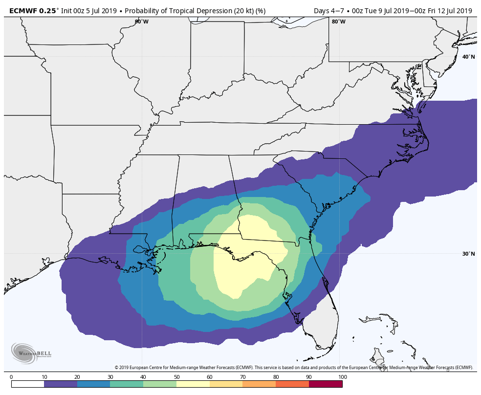
ECMWF Tropical Cyclone Probability (7/9 – 7/12).
THE TROPICS: The Atlantic Basin still remains rather quiet, and at this point, the NHC does not expect any tropical cyclone development within the next five days. However, we do note that the global models are hinting at some sort of tropical wave or low potentially developing near the Central Gulf Coast late in the week. This is just an idea out there on the table at this point, but if it does occur, we could see an increase in rain coverage across portions of the state. We’ll stay focused on it throughout the weekend.
BEACH FORECAST: Plenty of sunshine with only a small chance of an afternoon thunderstorm through the end of the weekend before rain chances increase a little for the start of next week. Highs will be in the lower 90s. Get the latest weather and rip current forecasts for the beaches from Fort Morgan to Panama City on our Beach Forecast Center page.
ALREADY OFF TO A HOT START IN 2019! ADVERTISE WITH THE BLOG!: We have enjoyed over 10 MILLION page views on AlabamaWx.com so far in 2019! Don’t miss out! We can customize a creative, flexible and affordable package that will suit your organization’s needs. Contact Bill Murray at (205) 687-0782.
E-FORECAST: Get the Alabama Wx Weather Blog’s Seven-Day Forecast delivered directly to your inbox by email twice daily. It is the most detailed weather forecast available in Central Alabama. Subscribe here… It’s free!
CONNECT WITH THE BLOG ON SOCIAL MEDIA: You can find the AlabamaWx Weather Blog on the major social media networks:
Facebook
Twitter
Instagram
WEATHERBRAINS: Don’t forget you can listen to our weekly 90 minute netcast anytime on the web at WeatherBrains.com or on iTunes, Stitcher, or Spotify. This is the show all about weather featuring many familiar voices, including the meteorologists at ABC 33/40.
Category: Alabama's Weather, ALL POSTS
About the Author (Author Profile)
Scott Martin is an operational meteorologist, professional graphic artist, musician, husband, and father. Not only is Scott a member of the National Weather Association, but he is also the Central Alabama Chapter of the NWA president. Scott is also the co-founder of Racecast Weather, which provides forecasts for many racing series across the USA. He also supplies forecasts for the BassMaster Elite Series events including the BassMaster Classic.Subscribe
If you enjoyed this article, subscribe to receive more just like it.


