

Midday: Can We Keep This Weather For The Rest Of Summer?
While we are definitely enjoying a break from the higher heat and humidity levels that we are used to seeing at this time of the year, the bad news is that those will begin to increase going into and through the weekend.
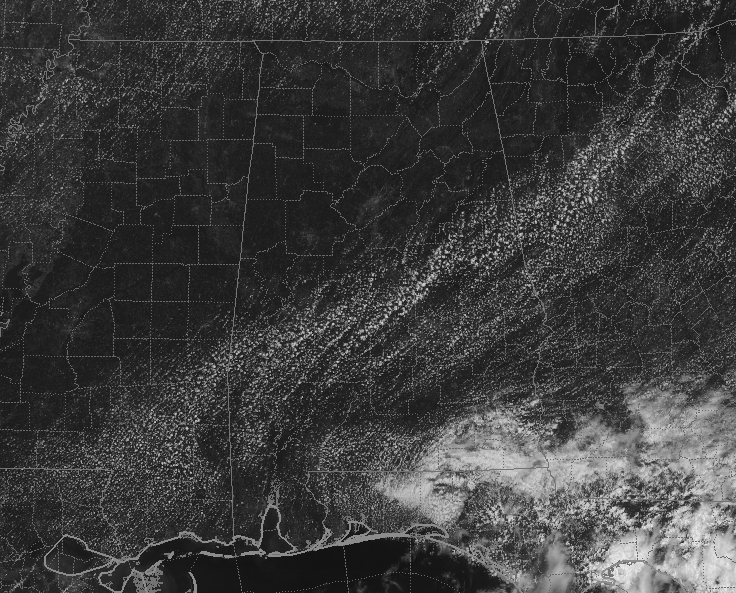
As of 12:45 pm, we currently have plenty of sunshine and very little in the way of fairweather clouds across Central Alabama, with much of the cloud cover in the southeast located over the northern Gulf of Mexico and across the north and central parts of the Florida Peninsula in association with the front that moved through Alabama on Tuesday. We’ll have to keep our eyes on the Gulf as there may be some tropical mischief brewing later in the week.
Temperatures are currently in the upper 70s to the mid-80s across Central Alabama from northwest to southeast. Haleyville and Cullman were the cool spots at 79 degrees, while Selma is the warm spot at 86 degrees. Birmingham was at 82 degrees, which is 9 degrees below normal. Add that to dewpoints in the mid-50s to the mid-60 and with a little breeze out of the north, it sure does feel very nice for a late-July day.
We can continue to expect mostly sunny skies across the area for the rest of the daylight hours with afternoon highs topping out in the mid to upper 80s across the area. For tonight, skies will clear out with overnight lows dipping into the upper 50s to the mid-60s across the area.
Afternoon highs will be warmer on Thursday, but with the lower moisture levels, it still will not be all that bad outside. Skies will be mostly sunny with highs reaching the mid-80s to the lower 90s… only about 3 degrees below normal.
As I mentioned earlier, we return to a more normal summertime pattern with hot and humid days. We will stay dry on Friday as it looks at this point, but we’ll have a small risk of an isolated afternoon shower or thunderstorm on Saturday and Sunday. Afternoon highs will be in the upper 80s to the lower 90s.
THE TROPICS
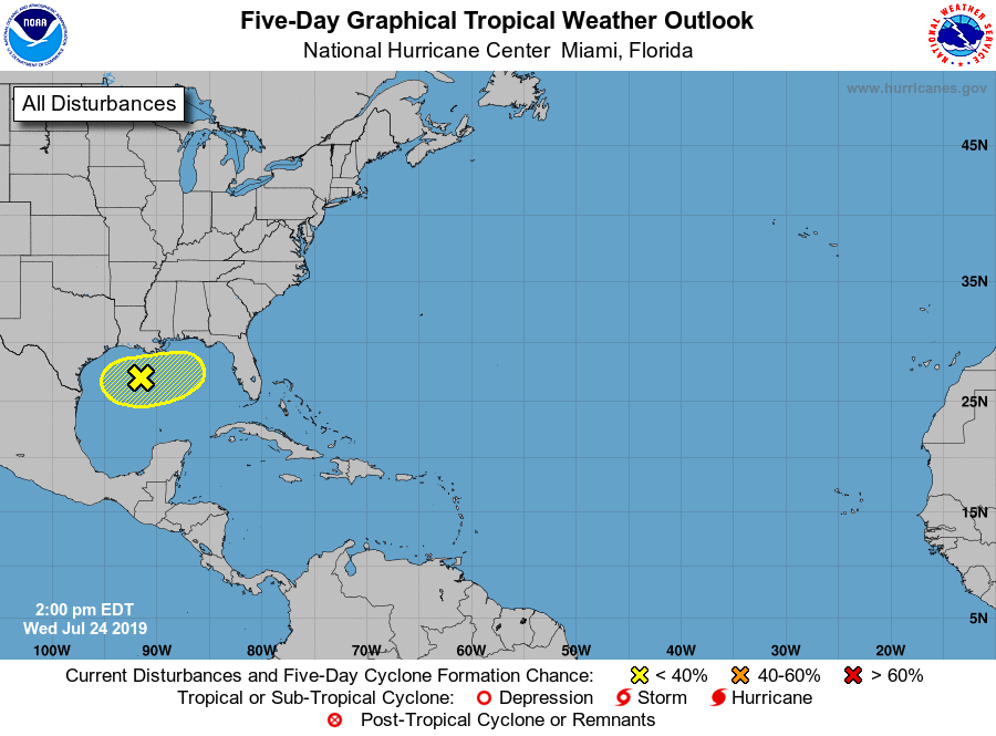
We are still looking at the very small potential of a tropical disturbance forming over the northern Gulf of Mexico later this evening or during the day tomorrow, but conditions are unfavorable for any significant development during the next few days. NHC is only giving it a 10% chance of becoming a depression within the next five days as it meanders around the northern Gulf. The rest of the Atlantic Basin is quiet.
ON THIS DAY IN WEATHER HISTORY
1947 – One of the most powerful strokes of lightning ever measured yielded 345,000 amperes of electricity in Pittsburgh, PA.
Category: Alabama's Weather, ALL POSTS
About the Author (Author Profile)
Scott Martin is an operational meteorologist, professional graphic artist, musician, husband, and father. Not only is Scott a member of the National Weather Association, but he is also the Central Alabama Chapter of the NWA president. Scott is also the co-founder of Racecast Weather, which provides forecasts for many racing series across the USA. He also supplies forecasts for the BassMaster Elite Series events including the BassMaster Classic.Subscribe
If you enjoyed this article, subscribe to receive more just like it.


