Very Hot At Midday With A Few Showers; Strong Storms Possible Tonight
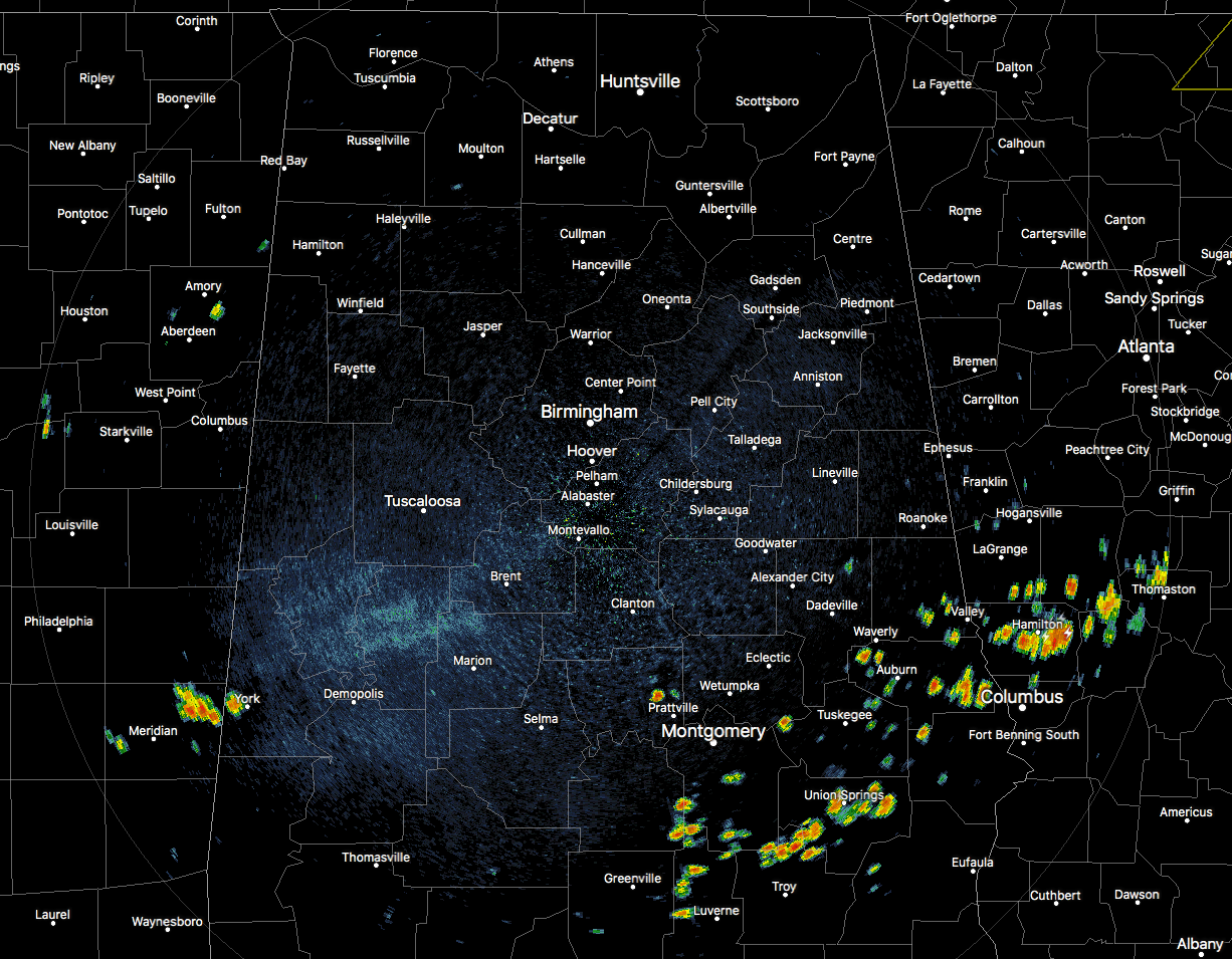
At 12:50 pm, much of North/Central is free from any rainfall but temperatures are really hot out there. If you don’t have to be outside, don’t go out. We do have some scattered shower and thunderstorm activity over the southeastern parts of the area, especially along and south of the I-85 corridor. There is another shower that is parked over I-59/20 in the city of York in Sumter County. Temperatures are ranging throughout the 90s across Central Alabama. Haleyville was the cool spot at 91 degrees while the hot spot is Montgomery at 99 degrees. Birmingham was at 97 degrees.
EXTREME HEAT WARNINGS & HEAT ADVISORIES IN EFFECT TODAY
An Excessive Heat Warning continues until 9:00 pm tonight for Autauga, Barbour, Bibb, Bullock, Chilton, Dallas, Elmore, Fayette, Greene, Hale, Lamar, Lowndes, Macon, Marengo, Marion, Montgomery, Perry, Pickens, Pike, Russell, Sumter, and Tuscaloosa counties in central Alabama.
A Heat Advisory continues until 9:00 pm tonight for Blount, Chambers, Clay, Coosa, Jefferson, Randolph, Shelby, St. Clair, Talladega, Tallapoosa, Walker, and Winston.
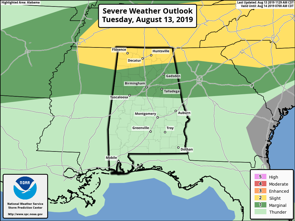
POTENTIAL FOR A FEW STRONG TO SEVERE STORMS LATER TONIGHT
Locations north of a line from Hamilton to Eva to Fort Payne have been placed in a Slight Risk of severe storms during the late night and into the overnight hours. Locations south of that line stretching as far south as Aliceville to Calera to Roanoke have been placed in a Marginal Risk for severe storms.
Scattered strong to severe storms will be possible during a window of 8:00 pm tonight through 2:00 am Wednesday as a cold front will approach and begin to move into the northern parts of the state. Damaging winds and small hail will be possible, along with the potential of some localized flash flooding with the strongest activity. Storms will weaken as they move south and much of the activity will diminish well before the break of dawn. Highest rain chances will be along and north of the Tennessee River while there will be a decent chance south of that down to the I-22 and I-20 corridors. Lows will be in the 70s across North/Central Alabama.
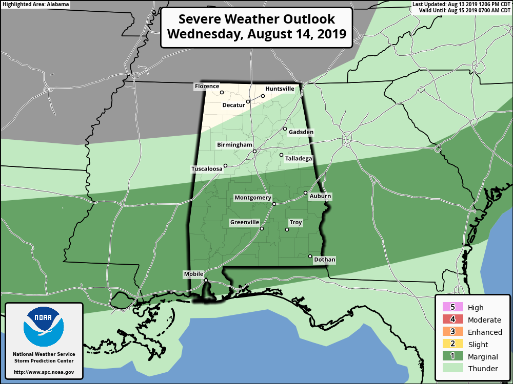
POTENTIAL FOR A FEW STRONG STORMS ON WEDNESDAY
Activity will begin to fire back up during the late morning through the afternoon hours as the cold front will continue to slowly move southward through the southern half of the area. It will eventually wash out over the extreme southern parts of the state late tomorrow night. Locations south of a line from Geiger to Jemison to Roanoke have been placed in a Marginal Risk for severe storms mainly in a window from 12:00 pm to 8:00 pm Wednesday night for the threat of isolated damaging wind bursts up to 60 MPH. Scattered to numerous showers and thunderstorms will be likely in the Marginal Risk locations, while rain chances drop greatly as you move north (20%-40%). Highs will be in the lower to mid-90s.
HEAT ADVISORY IN EFFECT FOR PARTS OF THE AREA ON WEDNESDAY
A Heat Advisory has been issued for Autauga, Barbour, Bullock, Dallas, Elmore, Lowndes, Macon, Marengo, Montgomery, Pike, Russell counties until 6:00 pm Wednesday evening. Heat index values in these counties have the potential to reach 105-109 degrees.
![]()
FREE PREPAREDNESS & SAFETY FESTIVAL FOR THE ENTIRE FAMILY
The National Weather Association Foundation is bringing WeatherReady Fest to the campus of the University of Alabama in Huntsville on September 7, 2019, from 10:00 am to 4:00 pm. This one-day festival will include family-friendly games, fun learning activities, large response vehicles, and enlightening speakers. Local and national celebrities will make special appearances, along with the NWA’s very own, Owlie Skywarn. Over 6,000 attendees showed up in St. Louis for last year’s event… let’s break that record this year. Get your free timed tickets now as they are going fast. More information and a link to the ticket site are available on the festival website at www.weatherreadyfest.com. Hope to see you there!
BEACH FORECAST CENTER
Get the latest weather and rip current forecasts for the beaches from Fort Morgan to Panama City on our Beach Forecast Center page. There, you can select the forecast of the region that you are interested in.
ALREADY OFF TO A HOT START IN 2019! ADVERTISE WITH THE BLOG!
After a record-setting 2018 with over 19.7 million page views, AlabamaWx.com is already well on its way to setting another record as we’re just topped 12 million page views so far in 2019! Don’t miss out! We can customize a creative, flexible and affordable package that will suit your organization’s needs. Contact Bill Murray at (205) 687-0782.
E-FORECAST
Get the Alabama Wx Weather Blog’s Seven-Day Forecast delivered directly to your inbox by email twice daily. It is the most detailed weather forecast available in Central Alabama. Subscribe here… It’s free!
CONNECT WITH THE BLOG ON SOCIAL MEDIA
You can find the AlabamaWx Weather Blog on the major social media networks:
Facebook
Twitter
Instagram
WEATHERBRAINS
Don’t forget you can listen to our weekly 90 minute netcast anytime on the web at WeatherBrains.com or on iTunes, Stitcher, or Spotify. This is the show all about weather featuring many familiar voices, including the meteorologists at ABC 33/40.
Category: Alabama's Weather, ALL POSTS, Severe Weather
About the Author (Author Profile)
Scott Martin is an operational meteorologist, professional graphic artist, musician, husband, and father. Not only is Scott a member of the National Weather Association, but he is also the Central Alabama Chapter of the NWA president. Scott is also the co-founder of Racecast Weather, which provides forecasts for many racing series across the USA. He also supplies forecasts for the BassMaster Elite Series events including the BassMaster Classic.Subscribe
If you enjoyed this article, subscribe to receive more just like it.


