Much Cooler For Half Of The Area Than Yesterday, It’s Still Hot At Midday
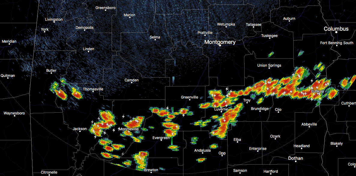
As of 12:40 pm, temperatures were in the mid-80s to the mid-90s across the area. Prattville was the hot spot at 94 degrees while Haleyville is at 84 degrees as the cool spot. Birmingham was at 90 degrees. The only activity going on across Central Alabama is located in the extreme southeastern parts of the area over portions of Pike, Bullock, Barbour, and Russell counties. Plenty of heavy rainfall and dangerous cloud-to-ground lightning are occurring with these storms, but none are particularly strong. These are all drifting to the southeast very slowly.
It is hard to believe that the daytime highs for today will nearly be 10 degrees cooler than on Tuesday for the northern half of Central Alabama, especially when highs will still top out in the lower 90s north of a line from Aliceville to Montevallo to Roanoke. South of that, heat levels will stay high reaching the mid to upper 90s with heat index values topping out in the 105-109 degree range.
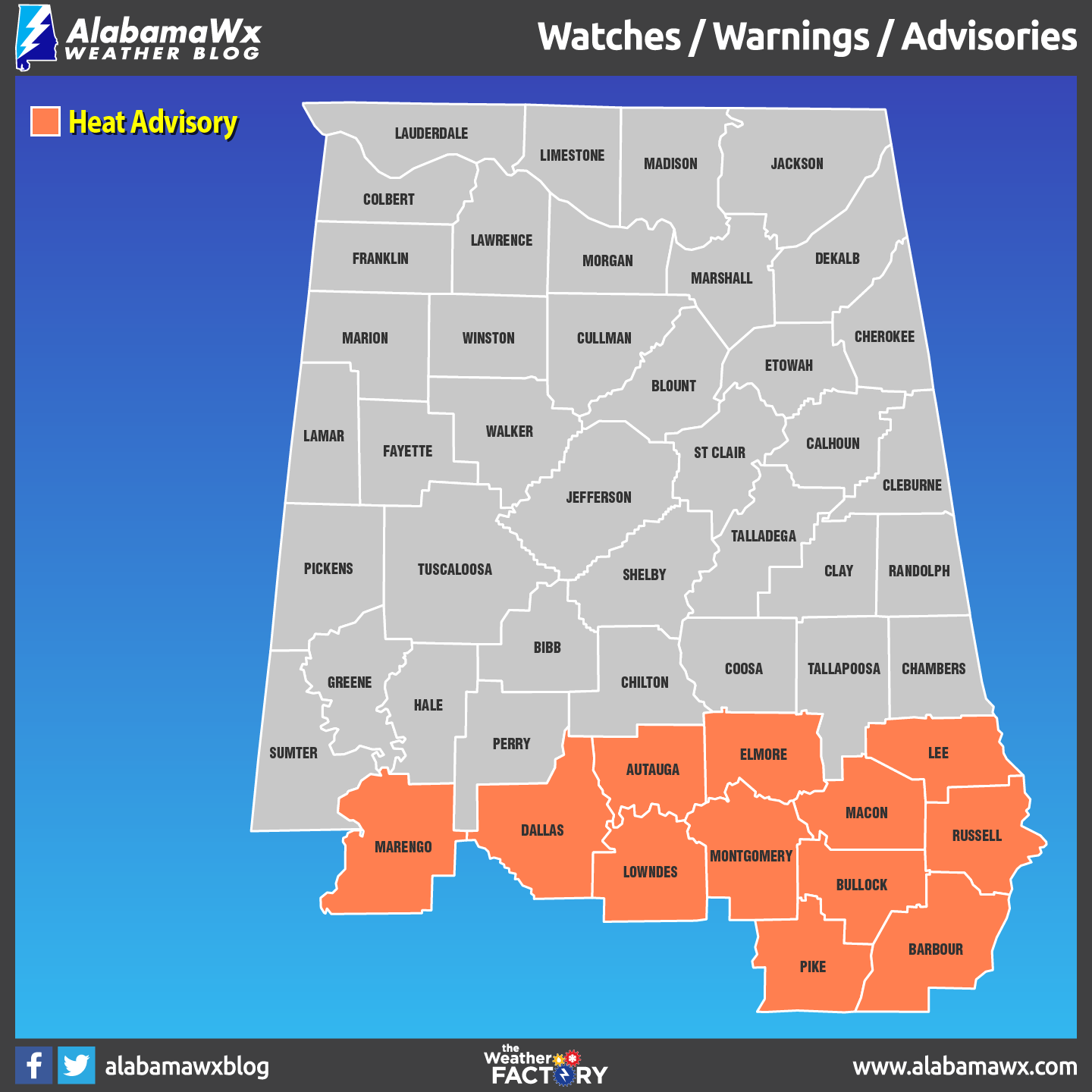
NWS Birmingham continues a Heat Advisory until 6:00 pm this evening for theses counties in the southern parts of Central Alabama: Autauga, Barbour, Bullock, Dallas, Elmore, Lowndes, Macon, Marengo, Montgomery, Pike, and Russell.
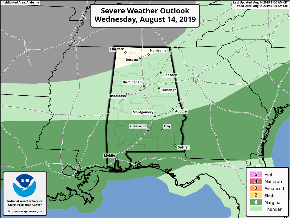
SPC continues a Marginal Risk for severe storms through the remainder of the afternoon and into the evening hours mainly for locations south of the US-80 and I-85 corridors. Isolated damaging wind gusts up to 60 MPH will be the main threat with any storm that goes severe. North of those two corridors, a few isolated to scattered showers and thunderstorms will be possible with the heating of the day, but the higher concentration of scattered to numerous showers and storms will be along and south of those corridors.
For tonight, any shower and storm activity should die off by 10:00 pm, but I wouldn’t be surprised if there are a couple of storms lingering around over the extreme southeastern parts of the area for a couple more hours. Lows will be in the upper 60s to the mid-70s across the area from northwest to southeast.
FREE PREPAREDNESS & SAFETY FESTIVAL FOR THE ENTIRE FAMILY
The National Weather Association Foundation is bringing WeatherReady Fest to the campus of the University of Alabama in Huntsville on September 7, 2019, from 10:00 am to 4:00 pm. This one-day festival will include family-friendly games, fun learning activities, large response vehicles, and enlightening speakers. Local and national celebrities will make special appearances, along with the NWA’s very own, Owlie Skywarn. Over 6,000 attendees showed up in St. Louis for last year’s event… let’s break that record this year. Get your free timed tickets now as they are going fast. More information and a link to the ticket site are available on the festival website at www.weatherreadyfest.com. Hope to see you there!
BEACH FORECAST CENTER
Get the latest weather and rip current forecasts for the beaches from Fort Morgan to Panama City on our Beach Forecast Center page. There, you can select the forecast of the region that you are interested in.
ALREADY OFF TO A HOT START IN 2019! ADVERTISE WITH THE BLOG!
After a record-setting 2018 with over 19.7 million page views, AlabamaWx.com is already well on its way to setting another record as we’re just topped 12 million page views so far in 2019! Don’t miss out! We can customize a creative, flexible and affordable package that will suit your organization’s needs. Contact Bill Murray at (205) 687-0782.
E-FORECAST
Get the Alabama Wx Weather Blog’s Seven-Day Forecast delivered directly to your inbox by email twice daily. It is the most detailed weather forecast available in Central Alabama. Subscribe here… It’s free!
CONNECT WITH THE BLOG ON SOCIAL MEDIA
You can find the AlabamaWx Weather Blog on the major social media networks:
Facebook
Twitter
Instagram
WEATHERBRAINS
Don’t forget you can listen to our weekly 90 minute netcast anytime on the web at WeatherBrains.com or on iTunes, Stitcher, or Spotify. This is the show all about weather featuring many familiar voices, including the meteorologists at ABC 33/40.
Category: Alabama's Weather, ALL POSTS
About the Author (Author Profile)
Scott Martin is an operational meteorologist, professional graphic artist, musician, husband, and father. Not only is Scott a member of the National Weather Association, but he is also the Central Alabama Chapter of the NWA president. Scott is also the co-founder of Racecast Weather, which provides forecasts for many racing series across the USA. He also supplies forecasts for the BassMaster Elite Series events including the BassMaster Classic.Subscribe
If you enjoyed this article, subscribe to receive more just like it.


