Active Saturday Afternoon of Rain and Storms
It is a very warm and muggy day, with temps in the upper 80s and lower 90s, but now that we are into the afternoon, showers and storms are beginning to develop across the Alabama landscape.
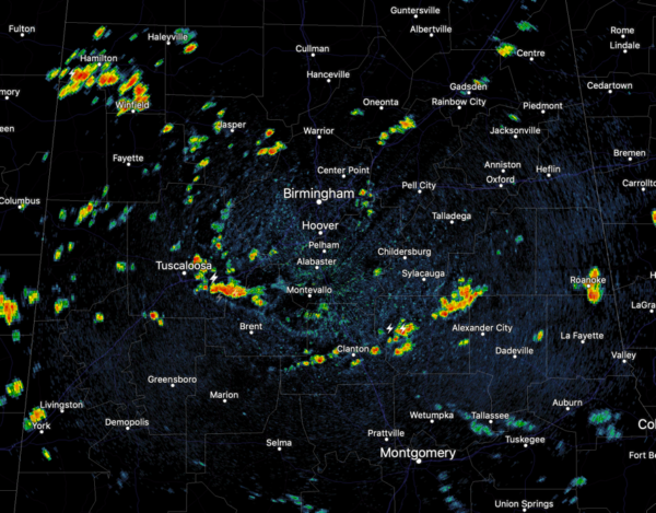
Like we have seen recently, rain will be widespread, but still not everyone will see rain today. With dew points well into the 70s, there is plenty of fuel for showers and storms again today and these will be producing a lot of lightning, tropical downpours, and gusty winds through the afternoon and evening hours. Like we saw yesterday, there could even be a few areas of isolated flash flooding. Heading into tonight, the threat for rain and storms will remain in the forecast, but should gradually wind down through the overnight hours. It will remain a very muggy night with lows in the 70s.
MORE OF THE SAME: Not much change in the forecast for tomorrow. It will be a mainly cloudy day, very warm and muggy with highs in the mid to upper 80s. Like today, widespread and numerous showers and storms are in the forecast, especially during the afternoon and evening hours. No way of knowing when and where the activity will develop, but just be prepared to dodge those raindrops at times tomorrow and keep the umbrella close to hand.
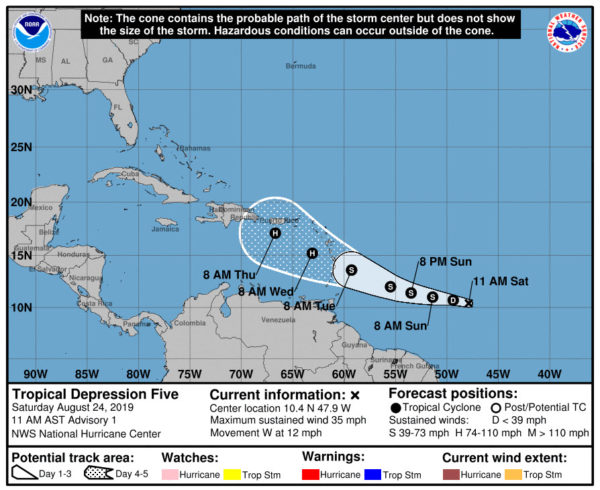
TROPICAL UPDATE: Chantal is no more, but we now have Tropical Depression Five, which will likely become Dorian in the coming days. The center of newly formed Tropical Depression Five was located near latitude 10.4 North, longitude 47.9 West. The depression is moving toward the west near 12 mph and this general motion is expected to continue today. A turn toward the west-northwest is forecast on Sunday, and that motion is expected to continue through Tuesday. On the forecast track, the tropical cyclone is expected to be near the central Lesser Antilles on Tuesday. Maximum sustained winds are near 35 mph with higher gusts. Gradual strengthening is forecast during the next few days, and the depression is forecast to become a tropical storm later tonight or on Sunday. The estimated minimum central pressure is 1010 mb (29.83 inches). Forecast model data shows this system becoming a hurricane as it approaches the islands the middle of next week.
Also, A broad area of low pressure located inland over South Florida is producing a large area of disorganized showers and thunderstorms that extends eastward over the northwestern Bahamas and the adjacent Atlantic waters. Significant development of the low is unlikely today while it drifts northward over the southern or central Florida peninsula. However, environmental conditions appear conducive for gradual development once the low moves off the east-central coast of Florida over the western Atlantic by Sunday, and a tropical or subtropical depression is likely to form early next week while the system moves northeastward offshore of the southeastern United States coast.
Regardless of development, locally heavy rains are possible over the northwestern Bahamas and the southern and central Florida peninsula through the weekend. Interests in the northwestern Bahamas, the Florida peninsula, and the southeastern coast of the United States should monitor the progress of this system. The Air Force Reserve Hurricane Hunter aircraft scheduled to investigate the system this afternoon has been canceled. Another aircraft is scheduled to investigate the system on Sunday. Formation chance through 48 hours…high…70 percent. Formation chance through 5 days…high…90 percent.
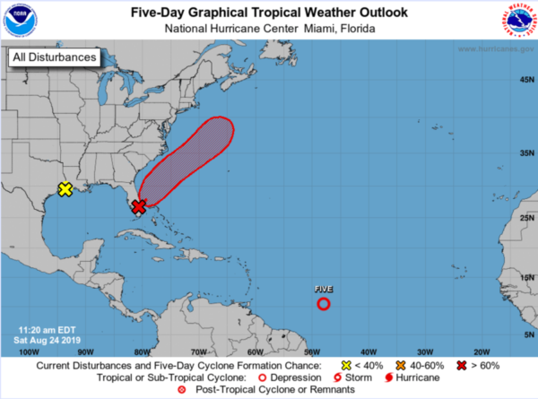
Plus, in the northwestern Gulf, surface observations and satellite imagery indicate that a low pressure area has formed just off the upper Texas and southwestern Louisiana coasts. The associated shower and thunderstorm activity shows signs of organization. However, the system is likely to move inland over eastern Texas and western Louisiana before significant development can occur. Regardless of development, this system is expected to bring locally heavy rains to portions of Louisiana and eastern Texas during the next day or two. Formation chance through 5 days…low…10 percent.
BEACH FORECAST CENTER: Get the latest weather and rip current forecasts for the beaches from Fort Morgan to Panama City on our Beach Forecast Center page. There, you can select the forecast of the region that you are interested in visiting.
WORLD TEMPERATURE EXTREMES: Over the last 24 hours, the highest observation outside the U.S. was 120.4F at Failakah Island, Kuwait. The lowest observation was -91.5F at Dome A, Antarctica.
CONTIGUOUS TEMPERATURE EXTREMES: The highest observation was 114F at Death Valley, CA. The lowest observation was 28F at Peter Sinks, UT.
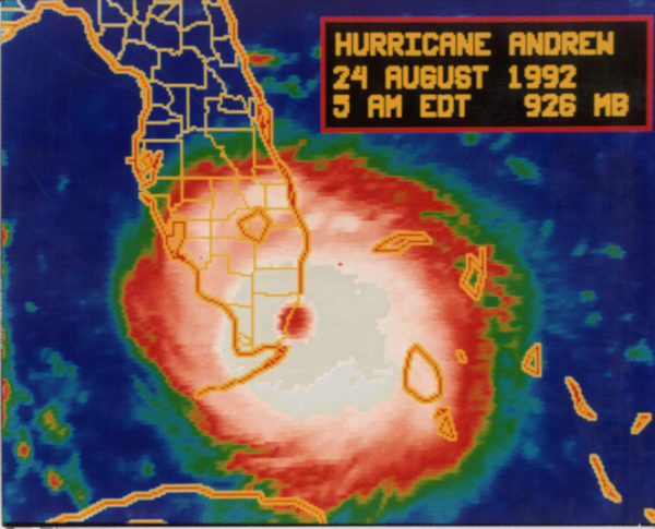
WEATHER ON THIS DATE IN 1992: Hurricane Andrew makes landfall in South Florida as a Category 5 storm with wind gusts in excess of 175 mph. Damages exceeded $27 billion (1992 USD), more than 60 people were killed and approximately 2 million people were evacuated from their homes.
Category: Alabama's Weather, ALL POSTS
About the Author (Author Profile)
Macon, Georgia Television Chief Meteorologist, Birmingham native, and long time Contributor on AlabamaWX. Stormchaser. I did not choose Weather, it chose Me. College Football Fanatic. @Ryan_StinnetSubscribe
If you enjoyed this article, subscribe to receive more just like it.


