September Heat Continues
SEPTEMBER HEAT CONTINUES: A strong upper ridge across the Deep South means temperatures will remain above average across Alabama this week, and prospects of beneficial rain will stay low. We project highs in the mid 90s each day through Friday… about 7-10 degrees above average for mid-September. The sky will be partly to mostly sunny, and while a few showers and storms are possible during the heat of the day, odds of any one place getting wet each afternoon are only in the 15-25 percent range.
THE ALABAMA WEEKEND: The ridge begins to weaken and shift westward. Still, on Saturday, any showers should be widely spaced with a partly sunny sky along with a high in the low 90s. Then, we expect an increase in the number of scattered showers and thunderstorms on Sunday with a high between 87 and 90 along with a mix of sun and clouds.
NEXT WEEK: While we still aren’t seeing any sign of a major, widespread rain event, we will have some risk of scattered showers and storms daily with highs holding in the 87 to 90 degree range. See the Weather Xtreme video for maps, graphics, and more details.
TROPICS: Tropical Storm Gabrielle, in the Atlantic far from land, is accelerating to the northeast, and will become post-tropical in the North Atlantic by mid-week. A tropical wave in the Atlantic between the coast of Africa and the Lesser Antilles is moving westward, and now has only a low chance of development due to strong winds aloft.
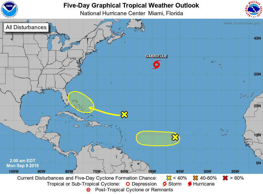
Another wave is north of the Leeward Islands, and conditions could become more favorable for development by late this week. This feature is moving in the general direction of the Bahamas; if tropical development does happen here it remains to be seen if it will impact the U.S.
ON THIS DATE IN 1965: Hurricane Betsy slammed into New Orleans on the evening of September 9, 1965. 110 mph winds and power failures were reported in New Orleans. The eye of the storm passed to the southwest of New Orleans on a northwesterly track. The northern and western eyewalls covered Southeast Louisiana and the New Orleans area from about 8 PM until 4 AM the next morning. In Thibodaux, winds of 130 mph to 140 mph were reported. The Baton Rouge weather bureau operated under auxiliary power, without telephone communication.
BEACH FORECAST: Click here to see the AlabamaWx Beach Forecast Center page.
WEATHER BRAINS: Don’t forget you can listen to our weekly 90 minute show anytime on your favorite podcast app. This is the show all about weather featuring many familiar voices, including our meteorologists here at ABC 33/40.
CONNECT: You can find me on all of the major social networks…
Facebook
Twitter
Instagram
Pinterest
Snapchat: spannwx
I am in Huntsville for the National Weather Association annual meeting, so just one video today and tomorrow, but I will post fresh forecast notes here this afternoon. Enjoy the day!
Category: Alabama's Weather
About the Author (Author Profile)
James Spann is one of the most recognized and trusted television meteorologists in the industry. He holds the AMS CCM designation and television seals from the AMS and NWA. He is a past winner of the Broadcast Meteorologist of the Year from both professional organizations.Subscribe
If you enjoyed this article, subscribe to receive more just like it.


