No Changes With TD-9 At 7:00 PM
Here is the latest from the National Hurricane Center…
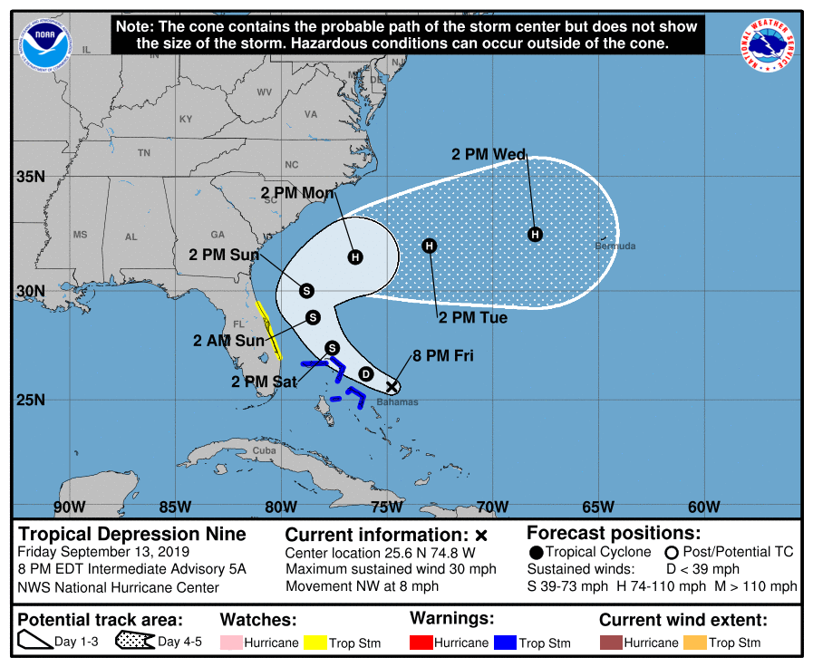
BULLETIN
Tropical Depression Nine Intermediate Advisory Number 5A
NWS National Hurricane Center Miami FL AL092019
800 PM EDT Fri Sep 13 2019
…NOAA HURRICANE HUNTERS INVESTIGATING THE DEPRESSION…
…EXPECTED TO BECOME A TROPICAL STORM ON SATURDAY…
SUMMARY OF 800 PM EDT…0000 UTC…INFORMATION
———————————————-
LOCATION…25.6N 74.8W
ABOUT 155 MI…245 KM ESE OF GREAT ABACO ISLAND
ABOUT 260 MI…420 KM ESE OF FREEPORT GRAND BAHAMA ISLAND
MAXIMUM SUSTAINED WINDS…30 MPH…45 KM/H
PRESENT MOVEMENT…NW OR 315 DEGREES AT 8 MPH…13 KM/H
MINIMUM CENTRAL PRESSURE…1008 MB…29.77 INCHES
WATCHES AND WARNINGS
SUMMARY OF WATCHES AND WARNINGS IN EFFECT:
A Tropical Storm Warning is in effect for…
* Northwestern Bahamas excluding Andros Island
A Tropical Storm Watch is in effect for…
* Jupiter Inlet to Flagler-Volusia County line
A Tropical Storm Warning means that tropical storm conditions are expected somewhere within the warning area within 36 hours.
A Tropical Storm Watch means that tropical storm conditions are possible within the watch area, generally within 48 hours.
Interests elsewhere along the east coast of Florida should monitor the progress of this system.
For storm information specific to your area in the United States, including possible inland watches and warnings, please monitor products issued by your local National Weather Service forecast office. For storm information specific to your area outside of the United States, please monitor products issued by your national meteorological service.
DISCUSSION AND OUTLOOK
At 800 PM EDT (0000 UTC), the center of Tropical Depression Nine was located near latitude 25.6 North, longitude 74.8 West. The depression is moving toward the northwest near 8 mph (13 km/h). A turn toward the north-northwest is expected on Saturday, with a slower northward motion forecast to occur on Sunday. On the forecast track, the system is anticipated to move very near the northwestern Bahamas tonight and Saturday, and offshore of the east coast of Florida this weekend.
Maximum sustained winds are near 30 mph (45 km/h) with higher gusts. Gradual strengthening is forecast, and the depression is expected to become a tropical storm on Saturday and a hurricane in a few days.
The estimated minimum central pressure based on data from the NOAA Hurricane Hunters is 1008 mb (29.77 inches).
HAZARDS AFFECTING LAND
WIND: Tropical storm conditions are expected within the warning area in the northwestern Bahamas by early Saturday. Tropical storm conditions are still possible in the watch area on the Florida peninsula by Saturday night.
RAINFALL: The depression is expected to produce these total rainfall accumulations through Sunday:
The Bahamas…2 to 4 inches, isolated maximum amounts 6 inches.
The U.S. Atlantic Coast from central Florida into South Carolina…2 to 4 inches.
STORM SURGE: This system is not expected to produce significant storm surge in the northwestern Bahamas.
SURF: Swells generated by the depression are expected to increase and affect the coasts of Central Florida to South Carolina late this weekend and early next week. These swells could cause life-threatening surf and rip current conditions. Please consult products from your local weather office.
About the Author (Author Profile)
Scott Martin is an operational meteorologist, professional graphic artist, musician, husband, and father. Not only is Scott a member of the National Weather Association, but he is also the Central Alabama Chapter of the NWA president. Scott is also the co-founder of Racecast Weather, which provides forecasts for many racing series across the USA. He also supplies forecasts for the BassMaster Elite Series events including the BassMaster Classic.Subscribe
If you enjoyed this article, subscribe to receive more just like it.


