Just Plain Ol’ Hot At Midday; Active In The Tropics
At 12:50 pm this afternoon, skies across Central Alabama are mainly clear with the exception of a few fair-weather cumulus clouds overhead. Temperatures were in the lower 90s to right at 100 degrees across the area. Uniontown leads the way at 100 degrees while the cool spots were Haleyville and Gadsden at 93 degrees. Birmingham was at 97 degrees.
It will be a mainly sunny day with very few in the way of clouds. With us continuing to receive subsidence from Humberto, we will remain dry and very hot. Afternoon highs will be in the upper 90s to just over 100 degrees. A Code Orange Air Quality Alert remains in effect for Jefferson and Shelby counties throughout the remainder of the daytime hours and into the evening. ground level ozone concentrations are expected to reach levels that are unhealthy for sensitive groups. Children and people with asthma are individuals most at risk under these expected conditions. Skies will be clear for tonight and overnight lows will dip into the upper 60s to the lower 70s across the area.
For much of Central Alabama on Wednesday, it will be a near repeat of todays weather. Skies will be mainly clear and temperatures climbing back up into the upper 90s to just over 100 degrees. There is a very slight risk of an isolated shower or two over the extreme eastern parts of the area during the afternoon hours, as we’ll begin to see the effects of a backdoor wedge that will bring a refreshing change to the forecast to end out the work week. That wedge will lower the highs for Thursday and Friday into the upper 80s to the lower 90s.
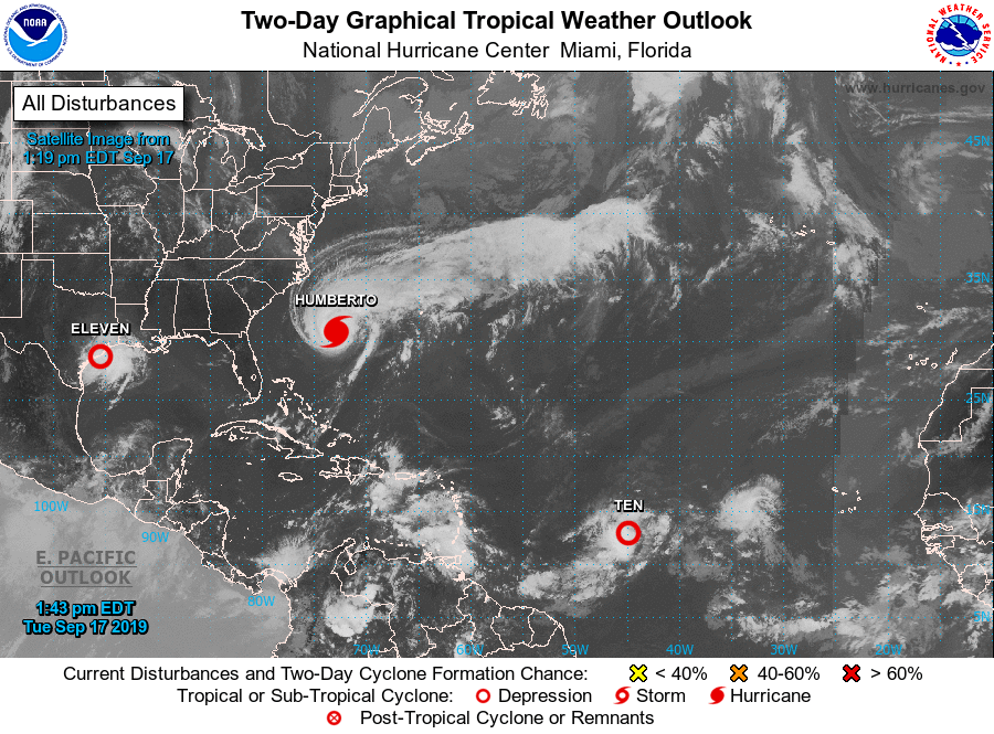
Hurricane Humberto continues to move away from the US mainland with maximum sustained winds now up to 100 MPH. Hurricane watches have been issued for Bermuda as the eye of Humberto will pass just to the north of the island on late Wednesday night. Rough surf and dangerous rip currents will continue to affect the Atlantic Coast of the southeast US for the next couple of days.
Tropical depression ten has formed over the central parts of the Tropical Atlantic Ocean. Current forecast track has it becoming Tropical Storm Imelda possibly as early as late this afternoon or into the evening hours. Movement is to the west-northwest and will approach the Leeward Islands by Thursday night or Friday morning, possibly as a hurricane. Most of the members of the ensemble have it curving back around to the north and away from the US Mainland, but there are a few that have it continuing on to the west-northwest. Just too early to tell at this point. We’ll have to keep our eye on this one.
Tropical Depression Eleven has just formed over the northwestern parts of the Gulf of Mexico and will be making landfall on the Texas Gulf Coast later today and into tonight. A Tropical Storm Warning has been issued for the coast of Texas. TD-11 could become a tropical storm before landfall. The main story will be the amount of rainfall for the upper coastal parts of Texas and into the far southwestern parts of Louisiana, as 5-10 inches are possible with isolated totals up to 15 inches possible. Life-threatening flash floods will be possible with this disturbance.
Category: Alabama's Weather, ALL POSTS, Tropical
About the Author (Author Profile)
Scott Martin is an operational meteorologist, professional graphic artist, musician, husband, and father. Not only is Scott a member of the National Weather Association, but he is also the Central Alabama Chapter of the NWA president. Scott is also the co-founder of Racecast Weather, which provides forecasts for many racing series across the USA. He also supplies forecasts for the BassMaster Elite Series events including the BassMaster Classic.Subscribe
If you enjoyed this article, subscribe to receive more just like it.


