Humberto Hitting Bermuda With Tropical-Storm-Force Winds, Hurricane-Force Expected Tonight
SUMMARY & DISCUSSION AS OF 1:00 PM CT
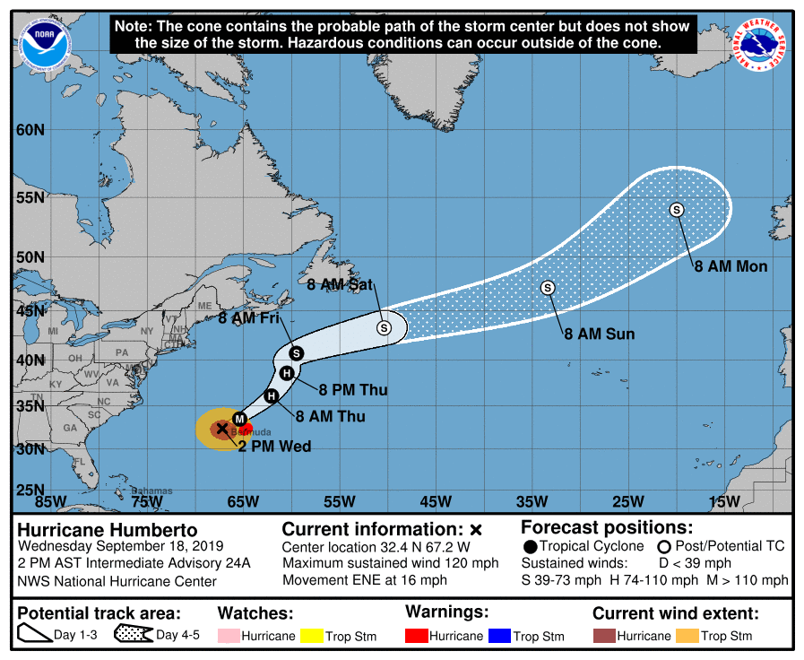
LOCATION…32.4N 67.2W
ABOUT 140 MI…225 KM W OF BERMUDA
MAXIMUM SUSTAINED WINDS…120 MPH…195 KM/H
PRESENT MOVEMENT…ENE OR 65 DEGREES AT 16 MPH…26 KM/H
MINIMUM CENTRAL PRESSURE…952 MB…28.12 INCHES
A Hurricane Warning is in effect for Bermuda.
At 200 PM AST (1800 UTC), the center of Hurricane Humberto was located by satellite and the Bermuda weather radar near latitude 32.4 North, longitude 67.2 West. Humberto is now moving toward the east-northeast near 16 mph (26 km/h). This general motion with an additional increase in forward speed is expected through early Thursday, followed by a northeastward to north-northeastward motion through Friday. On the forecast track, the core of Humberto is expected to pass just to the northwest and north of Bermuda later tonight.
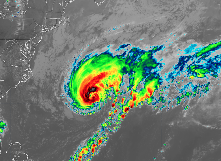
Maximum sustained winds are near 120 mph (195 km/h) with higher gusts. Humberto is a category 3 hurricane on the Saffir-Simpson Hurricane Wind Scale. Some fluctuations in intensity are likely during the next day or so, but Humberto should remain a powerful hurricane through early Thursday while it passes close to Bermuda. A steady weakening trend should begin later on Thursday.
Humberto is a large hurricane, with hurricane-force winds extending outward up to 105 miles (165 km) from the center and tropical-storm-force winds extending outward up to 195 miles (315 km) based on satellite-derived surface wind data. A wind gust to 51 mph (82 km/h) recently occurred at the Bermuda airport.
The estimated minimum central pressure is 952 mb (28.12 inches).
WIND: Hurricane conditions are expected to reach Bermuda by this evening and continue into early Thursday morning. Tropical-storm-force winds will occur on Bermuda through Thursday morning. Outside preparations are becoming difficult or dangerous and should be completed soon.
RAINFALL: Humberto may bring periods of heavy rain to Bermuda through Thursday, with rainfall accumulations of 2 to 4 inches with maximum amounts of 6 inches expected.
SURF: Large swells generated by Humberto will increase along the coast of Bermuda today. Dangerous breaking waves, especially along south-facing beaches, will be possible Wednesday night into Thursday, and could cause coastal flooding. Wave heights exceeding 30 feet have already been reported by an offshore NOAA buoy.
Swells will continue to affect the northwestern Bahamas and the southeastern coast of the United States from east-central Florida to North Carolina during the next couple of days. These swells could cause life-threatening surf and rip current
conditions.
STORM SURGE: Storm surge and breaking waves could raise water levels by 1 to 3 feet above normal tide levels along the immediate southern coast of Bermuda.
About the Author (Author Profile)
Scott Martin is an operational meteorologist, professional graphic artist, musician, husband, and father. Not only is Scott a member of the National Weather Association, but he is also the Central Alabama Chapter of the NWA president. Scott is also the co-founder of Racecast Weather, which provides forecasts for many racing series across the USA. He also supplies forecasts for the BassMaster Elite Series events including the BassMaster Classic.Subscribe
If you enjoyed this article, subscribe to receive more just like it.


