

Lorenzo Strengthens A Little More As It Moves West-Northwestward
SUMMARY OF 400 PM CDT INFORMATION
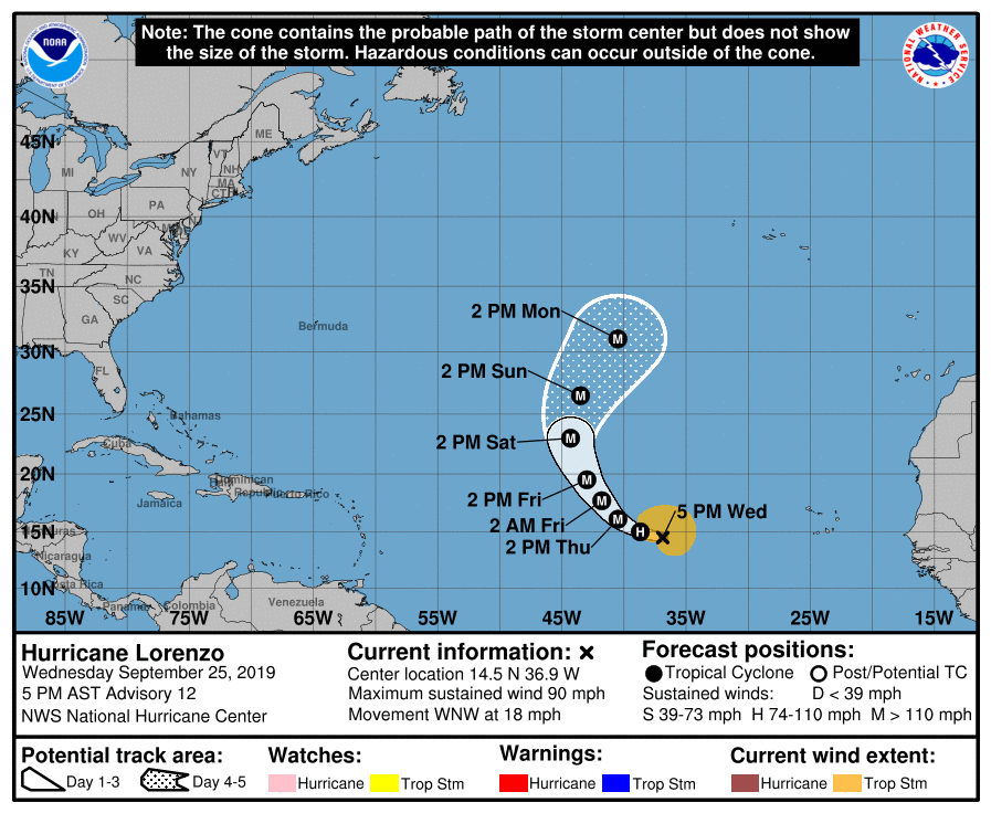
LOCATION…14.5N 36.9W
ABOUT 835 MI…1345 KM W OF THE SOUTHERNMOST CABO VERDE ISLANDS
MAXIMUM SUSTAINED WINDS…90 MPH…150 KM/H
PRESENT MOVEMENT…WNW OR 285 DEGREES AT 18 MPH…30 KM/H
MINIMUM CENTRAL PRESSURE…978 MB…28.88 INCHES

Conventional satellite imagery indicates that Lorenzo continues to become better organized, with the central dense overcast getting larger while a large complex of outer bands continues in the southeastern semicircle. In addition, an AMSR-2 overpass near 1530 UTC suggested there is at least a partial eyewall or convective ring near the center. The initial intensity is increased to 80 kt in best agreement with the CIMSS satellite consensus intensity estimate. The hurricane still shows good cirrus outflow in all directions, and it still appears some dry air is entraining into the system in the northwestern quadrant.
The initial motion is now 285/16. There is no change to the track forecast philosophy from the previous advisory. The subtropical ridge to the north and northeast of Lorenzo should steer the hurricane west-northwestward for the next day or so, followed by a turn toward the northwest as a break develops in the ridge between 45W-50W. Lorenzo is subsequently forecast to turn northward into the break by 96 h and recurve into the westerlies around 120 h. Since the last advisory, the track guidance has shifted a little to the right after 36 h. The new forecast track is similar to the previous track, but after 36 h it now lies a little to the left of the center of the guidance envelope.
Lorenzo should remain over warm water and in a light shear environment during the next three days, with the only negative factor for intensification being episodic intrusions of dry air. The intensity guidance forecasts continued steady strengthening for the next 36 h or so, but the chances of rapid intensification in the various statistical indices have gone down since the previous advisory. The new intensity forecast will call for 36 more hours of intensification, and it continues to lie near the upper edge of the intensity guidance. The intensity forecast follows the general trend of the guidance in showing little change in strength between 36-96 h, although fluctuations in intensity are likely due to eyewall replacement cycles during this time. After that time, Lorenzo is likely to encounter southwesterly shear, and thus some weakening is forecast.
About the Author (Author Profile)
Scott Martin is an operational meteorologist, professional graphic artist, musician, husband, and father. Not only is Scott a member of the National Weather Association, but he is also the Central Alabama Chapter of the NWA president. Scott is also the co-founder of Racecast Weather, which provides forecasts for many racing series across the USA. He also supplies forecasts for the BassMaster Elite Series events including the BassMaster Classic.Subscribe
If you enjoyed this article, subscribe to receive more just like it.


