

Lorenzo Now A Category 4 Hurricane

SUMMARY OF 1000 CDT INFORMATION
LOCATION…15.4N 40.2W
ABOUT 1055 MI…1695 KM W OF THE SOUTHERNMOST CABO VERDE ISLANDS
MAXIMUM SUSTAINED WINDS…130 MPH…215 KM/H
PRESENT MOVEMENT…WNW OR 295 DEGREES AT 13 MPH…20 KM/H
MINIMUM CENTRAL PRESSURE…949 MB…28.03 INCHES
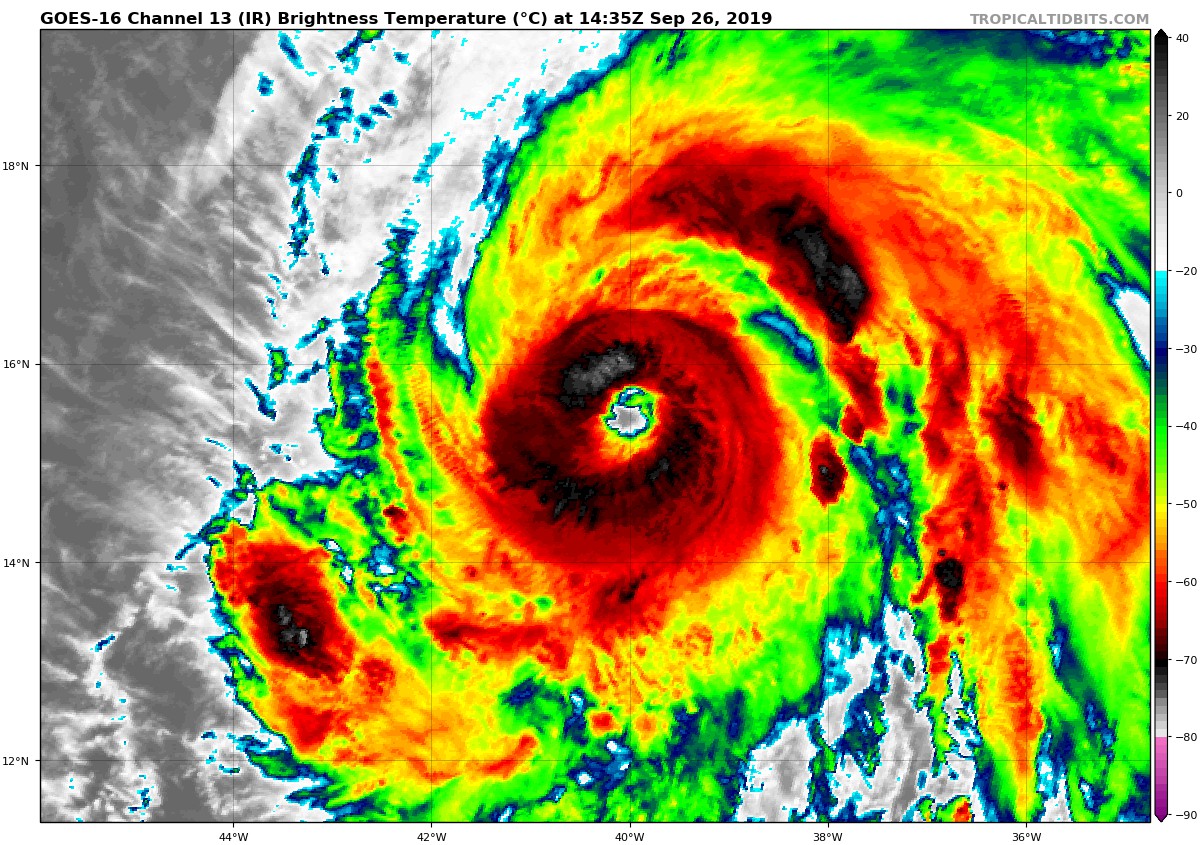
A review of microwave satellite imagery from last night suggests that Lorenzo underwent an eyewall replacement cycle, with the outer eyewall becoming predominant around 06Z-09Z. Around that time, the hurricane started to rapidly intensify, with the eye becoming much better defined in conventional satellite imagery. Raw Data-T numbers from both subjective and objective versions of the Dvorak Technique suggest that the maximum winds have increased to near 115 kt, which will be the initial intensity for this advisory. The initial wind radii have been revised based on a recently received scatterometer overpass.
The initial motion is 295/11. Lorenzo is approaching a developing break in the subtropical ridge caused by a series of mid-latitude troughs to the northwest of the hurricane, and the track guidance models are in excellent agreement that Lorenzo should recurve through the break during the forecast period. There are no significant changes to the guidance since the last advisory, and there are no significant changes to the forecast track either.
Data from the SHIPS model suggest that Lorenzo will be in an area of maximum potential intensities of 125-135 kt for the next 3-4 days. This suggests that the rapid intensification should end in the next 6-12 h as the actual intensity approaches those speeds. Fluctuations in strength due to eyewall replacement cycles are expected during the 12-36 h period. The global models suggest that Lorenzo will subsequently interact with an upper-level trough during recurvature, which should cause a period of increased shear and some weakening of the cyclone around 48 h. By 120 h, the hurricane should weaken due to movement over colder water and into strong shear in the mid-latitude westerlies.
While its exact ranking will be determined later, Lorenzo is one of the largest and most powerful hurricanes of record for the central tropical Atlantic, with the only comparable hurricane in recent times near there being Gabrielle of 1989.
About the Author (Author Profile)
Scott Martin is an operational meteorologist, professional graphic artist, musician, husband, and father. Not only is Scott a member of the National Weather Association, but he is also the Central Alabama Chapter of the NWA president. Scott is also the co-founder of Racecast Weather, which provides forecasts for many racing series across the USA. He also supplies forecasts for the BassMaster Elite Series events including the BassMaster Classic.Subscribe
If you enjoyed this article, subscribe to receive more just like it.


