Cold Front Exiting The State, Skies Clearing In The Northwest
AT MIDDAY
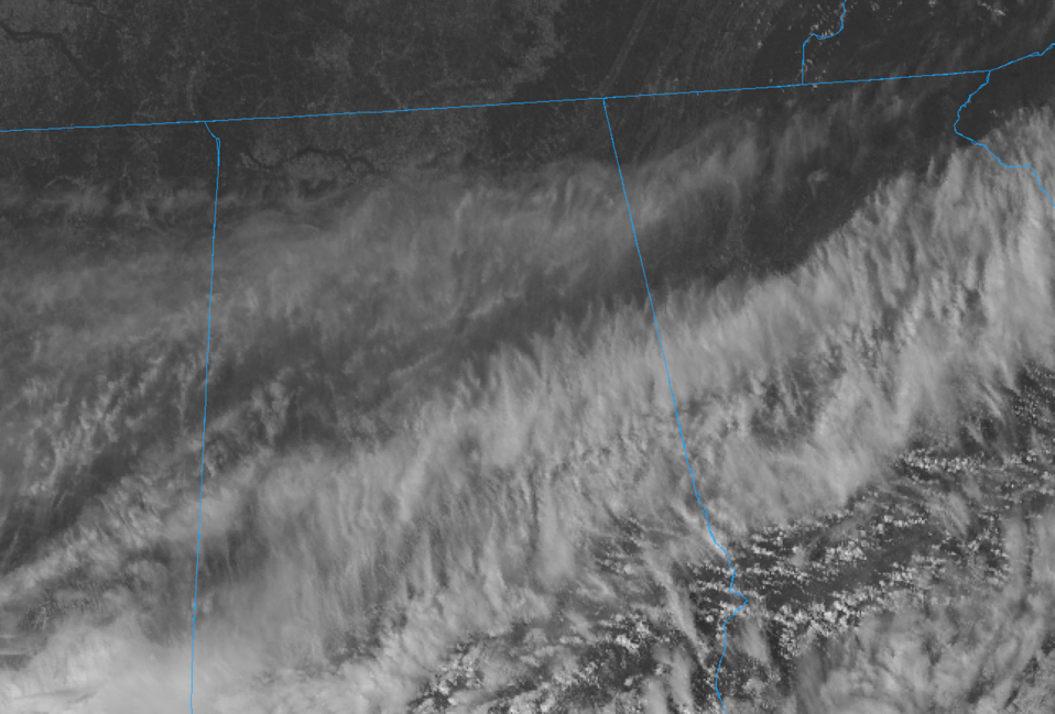
The cold front continues to move through the southeastern parts of Central Alabama as of 11:40 am, and you can feel the difference once the front has passed your location. Along and ahead of the front, skies are still mostly cloudy with temperatures in the lower 70s. Behind the front, skies are clearing from the northwest and temperatures are in the lower to mid-60s. Birmingham was at 64 degrees. Cullman was at 61 degrees as the cool spot while Troy is the warm spot at 73 degrees.
REST OF YOUR WEDNESDAY
Clouds will continue to slowly clear out from the northwest through the afternoon hours and rain chances have pretty much ended for much of Central Alabama with the exception of the extreme southeastern parts of the area. A few light showers may occur during the next couple of hours but we’ll be dry during the late afternoon and throughout the rest of the day. Highs will be in the mid-60s to the upper 70s across the area from northwest to southeast, but some of those have already been reached in the northwest and has started to fall by a few degrees. For tonight, skies will continue the slow clearing process, but there may be some patchy fog especially near bodies of water. Overnight lows will be chilly, down in the 40s across the area.
JUST OUTSTANDING WEATHER FOR THURSDAY & FRIDAY
We’ll have plenty of sunshine and very little in the way of any clouds as more typical fall conditions will be felt across Central Alabama on both days. Highs on Thursday will be in the mid-60s to near 70 degrees, while it will be just a touch warmer on Friday in the lower 70s across the area.
POTENTIAL TROPICAL SYSTEM MAY BRING MORE RAIN FOR THE WEEKEND
Rain chances look to increase for the weekend as we look to have a tropical system move up from the Gulf of Mexico and spreading tropical moisture over the southeast. There are some inconsistencies in the models at this point, but it looks like we’ll have a good chance of rain at times on both days with some breezy conditions. Latest QPF from the WPC shows 1/2-inch to 1-1/2 inches of rain through Sunday night across Central Alabama with higher totals south of the area. We’ll get a better idea as we get closer to the weekend on what to expect as the forecast can and will change, especially with a tropical system. Saturday’s highs will be in the lower to mid-70s while Sunday’s highs will be in the mid to upper 70s.
THE TROPICS
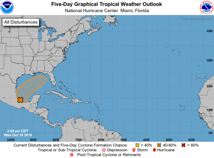
Here is the latest from the National Hurricane Center on the disturbance that could affect our weather for the weekend ahead:
A trough of low pressure located just offshore of the coast of southern Mexico, in the Bay of Campeche, is producing disorganized showers and thunderstorms. Gradual development is possible, and a tropical or subtropical cyclone could form late this week over the western or central Gulf of Mexico while the system is moving generally northeastward. An Air Force Reserve reconnaissance aircraft is scheduled to investigate the system this afternoon, if necessary.
* Formation chance through 48 hours…low…30 percent.
* Formation chance through 5 days…medium…50 percent.
The rest of the Atlantic Basin is quiet at this time, as TD-15 degenerated into a trough of low pressure earlier this morning.
ON THIS DAY IN WEATHER HISTORY
1987 – Ten cities in the southeastern U.S. reported record low temperatures for the date. The low of 34 degrees at Augusta GA marked their third straight morning of record cold. A cold front brought showers and thunderstorms to parts of the central U.S. Lightning struck a bull and six cows under a tree near Battiest OK.
Category: Alabama's Weather, ALL POSTS
About the Author (Author Profile)
Scott Martin is an operational meteorologist, professional graphic artist, musician, husband, and father. Not only is Scott a member of the National Weather Association, but he is also the Central Alabama Chapter of the NWA president. Scott is also the co-founder of Racecast Weather, which provides forecasts for many racing series across the USA. He also supplies forecasts for the BassMaster Elite Series events including the BassMaster Classic.Subscribe
If you enjoyed this article, subscribe to receive more just like it.


