

Tropical or Subtropical Storm Development Over The Southwestern Gulf Expected By Early Friday
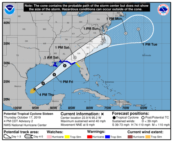
SUMMARY OF 400 PM CDT INFORMATION
LOCATION…22.9N 95.2W
ABOUT 180 MI…290 KM ENE OF TAMPICO MEXICO
ABOUT 570 MI…920 KM SW OF THE MOUTH OF THE MISSISSIPPI RIVER
MAXIMUM SUSTAINED WINDS…40 MPH…65 KM/H
PRESENT MOVEMENT…NNE OR 20 DEGREES AT 9 MPH…15 KM/H
MINIMUM CENTRAL PRESSURE…1005 MB…29.68 INCHES
A Tropical Storm Warning is in effect for…
* Mississippi/Alabama border to Aucilla River Florida
* Grand Isle Louisiana to the Mouth of the Pearl River
A Tropical Storm Watch is in effect for…
* East of Aucilla River to Yankeetown Florida
A Storm Surge Warning is in effect for…
* Indian Pass Florida to Clearwater Beach Florida
DISTURBANCE OVER THE SOUTHWESTERN GULF OF MEXICO NOW MOVING NORTH-NORTHEASTWARD WITH GALE-FORCE WINDS, EXPECTED TO DEVELOP INTO A TROPICAL OR SUBTROPICAL STORM LATER
TONIGHT OR ON FRIDAY.
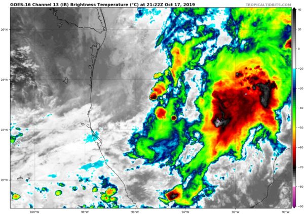
The complicated weather situation over the Gulf of Mexico described in the previous advisory continues to evolve. Recent scatterometer data shows that the tropical disturbance in the southwestern Gulf has a circulation elongated north-northeast to south-southwest, with winds of 30-35 kt occurring in the southwestern quadrant. However, the system currently has neither sufficient convection or a well-enough defined center to be designated a tropical or subtropical cyclone. The disturbance remains in close proximity to a mid- to upper-level low moving across southern Texas and northeastern Mexico and a frontal system over the northern and northwestern Gulf. One change from the previous global model guidance is the ECMWF and GFS have backed off of their forecasts of a separate baroclinic low to the north of the disturbance. Instead, the global models are in reasonable agreement that the disturbance, along with whatever vorticity centers form along the front, will be part of a large low-pressure area that will affect portions of the northern Gulf coast and the southeastern United States.
The initial motion of the disturbance is now 020/8. There is little change in the forecast track philosophy, the track guidance, or the NHC forecast track. The system should soon turn northeastward in the southern portion of the mid-latitude westerlies, and the track model guidance agrees on a continued northeastward motion through at least 72 h. The forecast track, which is in best agreement with the HCCA corrected consensus model, brings the system across the southeastern United States between 36-72 h and then has it moving into the Atlantic east of the mid-Atlantic States.
Gradual strengthening is expected as strong upper-level divergence caused by the trough partly prevails over strong vertical shear. Based on this, the intensity forecast again calls for gradual strengthening until landfall in agreement with the global model forecasts. While it remains unlikely that the system will develop into a classical tropical cyclone, the ECMWF and GFS models suggest enough organized convection will develop before landfall to make the system a tropical or subtropical cyclone. After landfall, the cyclone is forecast to become fully extratropical and gradually weaken.
Regardless of the exact evolution, portions of the northern coast of the Gulf of Mexico will experience strong winds, locally heavy rains, and storm surge on Friday and Saturday. Similar impacts are expected across portions of the Atlantic coast of the southeastern United States Saturday and Sunday.
KEY MESSAGES
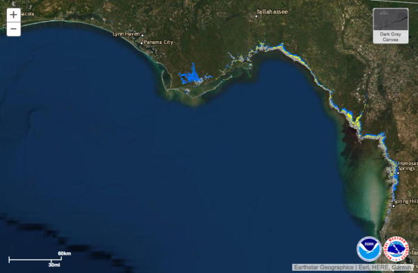
1. There is a danger of life-threatening storm surge inundation of up to 5 feet above ground level beginning Friday along the Florida Gulf Coast from Indian Pass to Clearwater, where a Storm Surge Warning is in effect. Residents in these areas should follow the advice given by local officials.
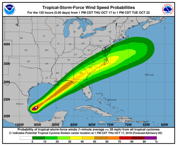
2. Tropical-storm-force winds are likely by Friday afternoon along portions of the central and eastern Gulf Coast, where tropical storm watches and warnings are in effect. Regardless of the exact track and intensity of the system, these winds will cover a large area, especially east of the center.
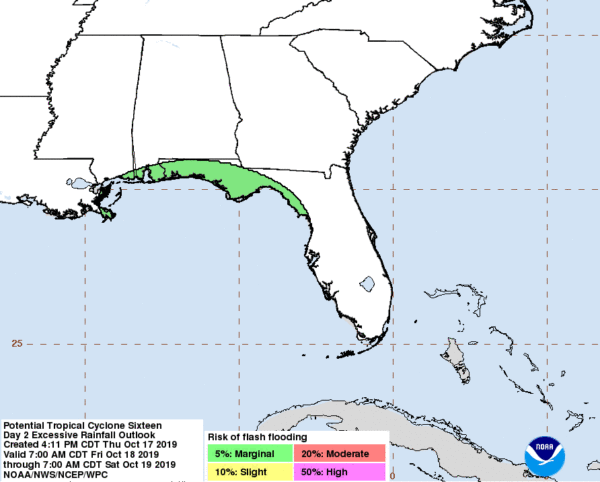
3. Isolated flash flooding is possible along the central and eastern Gulf Coast, mainly Friday and Friday night. Since soils across the southeast are dry, the risk of flash flooding will be confined to the immediate coast where heavier rainfall is possible.
4. Wind and coastal flooding hazards along the U.S. East Coast will be covered by non-tropical watches and warnings issued by local NWS offices, since the system, is expected to lose any tropical characteristics after it moves inland along the Gulf Coast.
About the Author (Author Profile)
Scott Martin is an operational meteorologist, professional graphic artist, musician, husband, and father. Not only is Scott a member of the National Weather Association, but he is also the Central Alabama Chapter of the NWA president. Scott is also the co-founder of Racecast Weather, which provides forecasts for many racing series across the USA. He also supplies forecasts for the BassMaster Elite Series events including the BassMaster Classic.Subscribe
If you enjoyed this article, subscribe to receive more just like it.


