Nestor’s Wind Speeds Stay The Same, Minimum Pressure Is Dropping
RAIN CONTINUES TO SPREAD INLAND OVER MUCH OF THE GULF COAST OF FLORIDA.
STORM SURGE AND WIND EXPECTED TO INCREASE SOON.
SUMMARY OF 1000 PM CDT…0300 UTC…INFORMATION
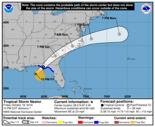
LOCATION…28.5N 87.0W
ABOUT 135 MI…215 KM ESE OF THE MOUTH OF THE MISSISSIPPI RIVER
ABOUT 140 MI…225 KM SW OF PANAMA CITY FLORIDA
MAXIMUM SUSTAINED WINDS…60 MPH…95 KM/H
PRESENT MOVEMENT…NE OR 45 DEGREES AT 23 MPH…37 KM/H
MINIMUM CENTRAL PRESSURE…996 MB…29.42 INCHES
SUMMARY OF WATCHES AND WARNINGS IN EFFECT
A Tropical Storm Warning is in effect for…
* Navarre Florida to Yankeetown Florida
A Storm Surge Warning is in effect for…
* Indian Pass Florida to Clearwater Beach Florida
DISCUSSION
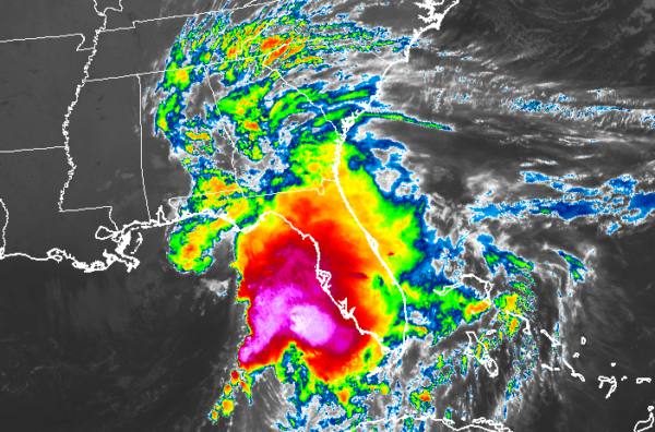
The Air Force and NOAA Hurricane Hunters are investigating Nestor this evening, and they have found that the minimum pressure has dropped to 996 mb, 3 mb lower than this afternoon, but they have not found higher winds yet. Based on preliminary data from both aircraft, the initial wind speed remains 50 kt. The Air Force also reported that there is a lot of lightning occurring in the thunderstorms on Nestor’s east side. Nestor remains a lopsided tropical storm, with very intense deep convection extending well to the east of the center with only small areas of convection near and to the west of the center. This asymmetric cloud pattern is due to strong westerly wind shear associated with a nearby shortwave trough. Doppler radar imagery indicates that rain bands are now spreading inland over much of the eastern portions of the Gulf coast, and surface observations show the winds increasing near the coast, but they are still not quite at tropical storm strength.
Water vapor satellite images show that the shortwave trough is almost co-located with Nestor, which is likely part of the reason why the minimum pressure has fallen. Even though it is not explicitly reflected in the forecast, Nestor could strengthen a little before the storm makes landfall. However, significant intensification seems unlikely as the shortwave trough is expected to bypass the cyclone soon, leaving the storm in a less favorable environment of upper-level confluence and drier air. After landfall, weakening is forecast and the models suggest that Nestor should lose its tropical characteristics on Saturday when it tracks across the southeast U.S. The weaker extratropical cyclone is expected to dissipate or merge with a cold front in about 4 days.
The tropical storm is moving quickly northeastward at about 20 kt. The models are in good agreement that this general motion should continue for the next couple of days, taking the center of the storm inland over the Florida Panhandle on Saturday morning and across portions of Georgia and the Carolinas later Saturday and Sunday. The weakening system is expected to slow down and turn eastward over the western Atlantic early next week before it merges with a cold front. The NHC track forecast is nudged to the west of the previous one to be in better agreement with the latest consensus models.
Given the structure of Nestor, dangerous storm surge and tropical-storm-force winds will occur along a large portion of the Florida Gulf Coast well east of the track of Nestor’s center through Saturday.
KEY MESSAGES
1. There is a danger of life-threatening storm surge inundation of up to 5 feet above ground level along the Florida Gulf Coast from Indian Pass to Clearwater Beach, where a Storm Surge Warning is in effect.
2. Tropical storm force winds are spreading across portions of the Florida Gulf Coast, where tropical storm warnings are in effect. Regardless of the exact track and intensity of the system, these winds will cover a large area, especially east of the center.
3. Isolated flash flooding is possible along the central and eastern Gulf Coast and Southeast United States coast into early Sunday morning.
4. Wind and coastal flooding hazards along the U.S. East Coast will be covered by non-tropical watches and warnings issued by local NWS offices, since the system is expected to lose its tropical characteristics after it moves inland along the Gulf Coast.
About the Author (Author Profile)
Scott Martin is an operational meteorologist, professional graphic artist, musician, husband, and father. Not only is Scott a member of the National Weather Association, but he is also the Central Alabama Chapter of the NWA president. Scott is also the co-founder of Racecast Weather, which provides forecasts for many racing series across the USA. He also supplies forecasts for the BassMaster Elite Series events including the BassMaster Classic.Subscribe
If you enjoyed this article, subscribe to receive more just like it.


