Tornado Watch Issued For Southwest Alabama Through 4:00 PM This Afternoon
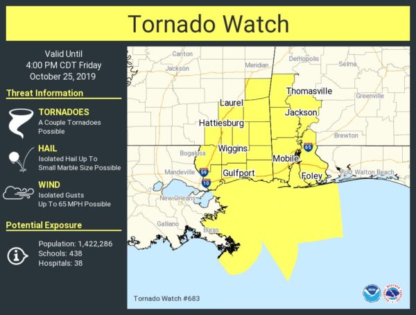
The Tornado Watch includes Choctaw, Clarke, Washington, Mobile, and Baldwin counties in Southwest Alabama through 4:00 pm this afternoon.
The NWS Storm Prediction Center has issued a
* Tornado Watch for portions of
– Southwest Alabama
– Southeast Mississippi
– Coastal Waters
* Effective this Friday morning and afternoon from 950 AM until 400 PM CDT.
* Primary threats include…
– A couple tornadoes possible
– Isolated damaging wind gusts to 65 mph possible
SUMMARY
A few supercells are possible across coastal Mississippi and Alabama. A couple tornadoes are the primary hazard, with this threat expanding north of the coast through this afternoon.
The tornado watch area is approximately along and 65 statute miles east and west of a line from 50 miles east of Boothville LA to 45 miles east northeast of Pine Belt MS.
PRECAUTIONARY/PREPAREDNESS ACTIONS…
REMEMBER
A Tornado Watch means conditions are favorable for tornadoes and severe thunderstorms in and close to the watch area. Persons in these areas should be on the lookout for threatening weather conditions and listen for later statements and possible warnings.
Category: Alabama's Weather, ALL POSTS, Severe Weather, Tropical
About the Author (Author Profile)
Scott Martin is an operational meteorologist, professional graphic artist, musician, husband, and father. Not only is Scott a member of the National Weather Association, but he is also the Central Alabama Chapter of the NWA president. Scott is also the co-founder of Racecast Weather, which provides forecasts for many racing series across the USA. He also supplies forecasts for the BassMaster Elite Series events including the BassMaster Classic.Subscribe
If you enjoyed this article, subscribe to receive more just like it.


