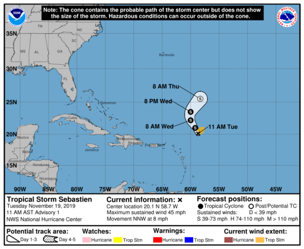
Tropical Storm Sebastien Forms; Expected To Remain Over Open Waters
SUMMARY OF 900 AM CST…1500 UTC…INFORMATION
———————————————–
LOCATION…20.1N 58.7W
ABOUT 275 MI…445 KM NE OF THE LEEWARD ISLANDS
MAXIMUM SUSTAINED WINDS…45 MPH…75 KM/H
PRESENT MOVEMENT…NNW OR 330 DEGREES AT 8 MPH…13 KM/H
MINIMUM CENTRAL PRESSURE…1008 MB…29.77 INCHES
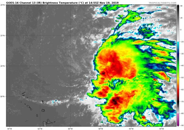
Satellite imagery indicates that the overall cloud pattern of the disturbance has improved since yesterday and that the low has become well-defined. In addition, a late-arriving ASCAT-B scatterometer pass showed 35-38 kt winds extending 90 n mi from the center in the northeastern quadrant. This pass also revealed that the low was nearly closed at the surface, and since the scatterometer may not have resolved the small scale of the low-level center it is likely that the surface low is indeed closed. Based on these data, advisories are being initiated on Tropical Storm Sebastian with an initial advisory intensity of 40 kt.
Sebastien will not be in an ideal environment for significant intensification, as it will be battling dry air to its west and about 20 kt of northwesterly shear for the next couple of days. However, due to the presence of an upper trough to the west of the system, a diffluent environment aloft may aid in some slight strengthening over the next day or so. After that time, the storm will begin to interact with an approaching cold front, and some additional intensification may occur due to baroclinic processes. The cyclone is then expected to become absorbed by the front in about 48 hours. The various intensity guidance solutions are in decent agreement, and the official forecast is near the mean of these forecasts. There are some timing variations among the models on when the cyclone will become absorbed by the front, and it is possible that the storm could be absorbed sooner than indicated.
The initial motion is 330/07 kt. Sebastien will be steered to the northwest in the near term around a deep-layer ridge over the central Atlantic. By Wednesday, the cyclone should turn north, and then should accelerate northeastward by Wednesday night as the cyclone gets caught up in the flow between the retreating ridge and ahead of the approaching cold front. The model guidance is in good agreement on this scenario, and on the official forecast track the cyclone will remain over open waters for the duration of its existence.
Category: ALL POSTS
About the Author (Author Profile)
Scott Martin is an operational meteorologist, professional graphic artist, musician, husband, and father. Not only is Scott a member of the National Weather Association, but he is also the Central Alabama Chapter of the NWA president. Scott is also the co-founder of Racecast Weather, which provides forecasts for many racing series across the USA. He also supplies forecasts for the BassMaster Elite Series events including the BassMaster Classic.Subscribe
If you enjoyed this article, subscribe to receive more just like it.


