Nice Day Ahead for Your Sunday with Partly Cloudy Skies and Slightly Cool Temps
Well, we actually get to use the precipitation type products in our model suites as we go through the next couple of weeks and toward winter. Could we be mentioning the wintry mix wording in some of our upcoming forecasts? Let’s check it out.
BENEFICIAL RAINS SATURDAY: Some decent rains across the state Friday night and Saturday. The northern half of the state picked up one half to one inch, with a swatch on 1-2 inch amounts generally across the I-20 Corridor. A large part of northwestern Alabama picked up between 1-3 inches, with the heaviest amounts across Franklin and Lawrence Counties.
PARTLY SUNNY SUNDAY: After a cloudy start for the eastern two-thirds of the area, today will feature increasing sunshine across the state, even as some stratocumulus clouds fill in inside the cold air behind the departing low. Temperatures will climb out of chilly 30s and lower 40s and highs will be in the 50s across the entire area, with just a 60F or two in places like Demopolis and Camden. Lows tonight will be in the lower and middle 30s. There could be a light freeze in spots.
START TO THE HOLIDAY WEEK: By tomorrow, lots of upper-level energy will be diving into the Rockies, set to create our holiday week weathermaker #1. Alabama will be dry and mild, with highs in the lower and middle 60s. Skies will be mostly sunny.
TUESDAY/WEDNESDAY: A strengthening surface low will be over Kansas. Heavy snow will spread across Colorado, Nebraska, and Kansas. Rain and storms will spread into the area from Missouri/Illinois into the Arklamiss. A few showers will work their way into Alabama late on Tuesday continuing into Wednesday morning. Other issues nationally will include snows over northern California, the Sierras, and southern Oregon. Lastly, another low off Baja will spread a wintry mix into much of New Mexico and western Texas.
WEDNESDAY: It may take the better part of the day before the rain clears southeastern parts of the area. Rainfall amounts will be around one half to three-quarters of an inch. Nationally, the heavy snow will be spreading across Iowa, Wisconsin, and southern Minnesota.
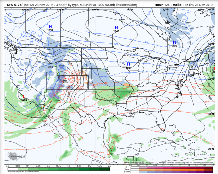
Noon on Thanksgiving Day
TURKEYCAST: Dry and mild weather will be the highlight for Thursday for Alabama. Highs will be around 60F into the lower 60s. Lows Thanksgiving morning will be in the middle 40s.
BLACK FRIDAY: Another surface low will be heading toward the Midwest by late Thursday. This will put Alabama in the warm advection pattern ahead of the developing cyclone. We will see increasing clouds during the day, and a few showers could show up by afternoon. Highs on Friday will be in the lower 60s. The main rainfall may not arrive until late Friday night into Saturday morning.
IRON BOWL SATURDAY: Saturday looks very wet across Central Alabama with steady rains progressing slowly across the state, much like it was yesterday morning. It will be mild, with highs in the middle and upper 60s.
HEADING HOME: Watch for travel issues late Friday night, Saturday and into Sunday from Chicago across parts of Indiana, Ohio and into the Northeast. The Rockies, northern Plains and into Minnesota and Wisconsin will experience widespread snowfall as well.
SUNDAY SNOW FLURRY? In the cold air advection pattern behind that low, there could be an accidental snow flurry somewhere across northern or northeastern Alabama. Not anything significant, but just a sign of the season.
VOODOO COUNTRY: A passing disturbance may bring precipitation on Friday the 6th and Saturday the 7th. There are hints that temperatures could be cold enough for there to be some wintry mix somewhere in the Southeast, perhaps even into northern Alabama.
TROPICS: Sebastien has ignored the predictions of an early end to the Atlantic Hurricane Season, The tropical storm is located between Bermuda and the Azores this morning. It will impact the islands of the Azores late tonight and Monday as a tropical storm or post-tropical storm.
GULF COAST WEATHER: Folks heading to the beach for the holiday will experience a few showers late Tuesday into Wednesday, and another round late Saturday into Sunday. By Tuesday, highs will be up in the 70s, with lows in the upper 50s and 60s each morning. Water temperatures are still holding in the middle 60s, a little chilly for my liking. Rip currents will be a problem today. Click here to see the Beach Forecast Center page.
WEATHERBRAINS: This week, the panel will entertain storm chaser Reed Timmer. Check out the show at www.WeatherBrains.com. You can also subscribe on iTunes. You can watch the show live at live.bigbrainsmedia.com You will be able to see the show on the James Spann 24×7 weather channel on cable or directly over the air on the dot 2 feed.
ON THIS DATE IN 1944: On the first bombing run on Japan following Jimmy Doolittle’s raid in 1942, U.S. Air Force B-29 bombers encountered a 140 mph tailwind that pushed their ground speed to nearly 500 mph and made precision bombing impossible. The mission was a tactical failure. The U.S. Air Force had discovered the jet stream. Follow my weather history tweets on Twitter. I am @wxhistorian at Twitter.com.
Category: Alabama's Weather, ALL POSTS
About the Author (Author Profile)
Bill Murray is the President of The Weather Factory. He is the site's official weather historian and a weekend forecaster. He also anchors the site's severe weather coverage. Bill Murray is the proud holder of National Weather Association Digital Seal #0001 @wxhistorianSubscribe
If you enjoyed this article, subscribe to receive more just like it.


