

A Brief Evening Rush Hour Check On Our Weather Situation
As of 5:20 this evening, we have some shower activity that has moved into the northwest and western parts of North/Central Alabama. There are a few stray light showers that have pushed closer to the I-65 corridor in the southern parts of the area. The good news at this point is that the shower activity, for the most part, is light with a few showers that are a little more moderate in intensity. No lightning at this point as well.
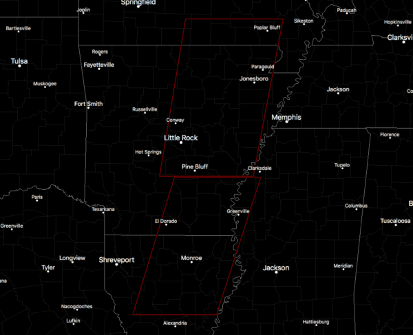
Tornado watches are in effect stretching from the southern and southeastern parts of Missouri, down through much of the eastern half of Arkansas, and down into the northeastern parts of Louisiana. Those are the only two watches in effect across the southeastern US.
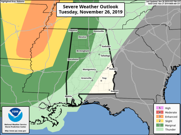
The latest Severe Weather Outlook graphic from the Storm Prediction Center continues to have parts of North/Central Alabama west of a line from New Hope to Birmingham to Demopolis in a Marginal Risk for severe storms mainly for midnight through the overnight hours. Isolated damaging wind gusts up to 60 MPH and a brief tornado can’t be ruled out.
A weakening line of showers and thunderstorms associated with a cold front will begin to move into the northwestern parts of the state as early as 10:00-11:00 pm and will move eastward through the area during the overnight and eventually nearly completely dissipating before the midday hours on Wednesday as it exits the area. Rain and storms will reach the Birmingham metropolitan area around the 2:00-3:00 am timeframe.
By the time it reaches the I-59 corridor, the line will have weakened enough for the severe weather threat to be over. To the west of that, helicity along with shear will be relatively strong, but we lack the amount of surface-based instability that would make this a larger severe storm threat. However, there is just enough instability to keep a non-zero threat of damaging winds and a brief tornado or two.
As I said earlier today… This is not uncommon for this time of the year as this is our secondary severe weather season in North/Central Alabama. Just have your safety kits and your place of safety ready to go just in case your location goes under a warning. Keep those smartphones charged and make sure you have good batteries in your flashlights and in your NOAA WeatherRadio.
Category: Alabama's Weather, ALL POSTS, Severe Weather
About the Author (Author Profile)
Scott Martin is an operational meteorologist, professional graphic artist, musician, husband, and father. Not only is Scott a member of the National Weather Association, but he is also the Central Alabama Chapter of the NWA president. Scott is also the co-founder of Racecast Weather, which provides forecasts for many racing series across the USA. He also supplies forecasts for the BassMaster Elite Series events including the BassMaster Classic.Subscribe
If you enjoyed this article, subscribe to receive more just like it.


