Showers On The Increase In The Southern Half Of Central Alabama At Midday
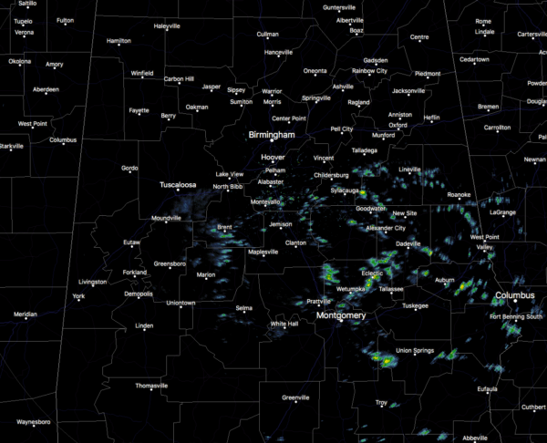
Spotty showers have already started to dot the radar at 12:00 pm across the southern half of Central Alabama while the edge of the clouds has now advanced north of the I-20 corridor. Unfortunately, clouds and rain chances will be on the increase as we get later into the day as showers will move up from the south. Rain will become likely over the southeastern parts of the area before sunset while there will be a chance of showers as far west as Demopolis and Tuscaloosa and as far north as Morris and Gadsden. Highs look to top out in the 50s across the area.
Rain chances will continue to increase across the area from southeast to northwest during the evening through the overnight hours and all of the area will see a chance of showers. Rain will be likely along and south of a line from Demopolis to Montevallo to Gadsden and a few claps of thunder may be heard in those parts. Lows will get down into the lower to mid-40s.
No improvement on Friday as showers and a few thunderstorms will be likely at times throughout the day. It doesn’t look like it will be a full day of rain, but you can expect it at any time throughout the daylight and into the evening hours. Nearly all of the activity will be out of the area by midnight, with a small possibility of a lingering shower or two may be possible through the overnight hours. Highs will once again be in the 50s.
HEADS UP FOR THE POTENTIAL OF SEVERE STORMS ON MONDAY
At this point, models are showing a good bit of vertical shear and higher helicity during the day, and a strong low-level jet will be moving into Central Alabama. Mid-level lapse rates look to be supportive or severe storms and surface-based instability looks to be at or over 500 J/kg. Signs are pointing to the potential of an active day on Monday.
All modes of severe weather look to be possible: tornadoes, damaging winds up to 60 MPH, and hail of 1-inch in diameter. The main window for severe storms look to be from noon to midnight on Monday.
NWS Birmingham already has a Slight Risk for severe storms (level 2 of 5) up for locations along and west of a line from Hanceville to Vance to Demopolis and a Marginal Risk (level 1 of 5) up for locations east of that line.
We’ll have updates throughout the rest of the week and weekend on this developing weather situation.
Category: Alabama's Weather, ALL POSTS, Severe Weather
About the Author (Author Profile)
Scott Martin is an operational meteorologist, professional graphic artist, musician, husband, and father. Not only is Scott a member of the National Weather Association, but he is also the Central Alabama Chapter of the NWA president. Scott is also the co-founder of Racecast Weather, which provides forecasts for many racing series across the USA. He also supplies forecasts for the BassMaster Elite Series events including the BassMaster Classic.Subscribe
If you enjoyed this article, subscribe to receive more just like it.


