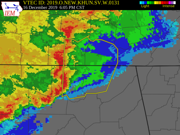
Severe T-Storm Warning: Parts Of Jackson, Madison Counties Until 7:00 PM
The National Weather Service in Huntsville Alabama has issued a
* Severe Thunderstorm Warning for…
Northwestern Jackson County in northeastern Alabama…
Madison County in north central Alabama…
Moore County in Middle Tennessee…
Eastern Lincoln County in Middle Tennessee…
Franklin County in Middle Tennessee…
* Until 700 PM CST.
* At 602 PM CST, severe thunderstorms were located along a line
extending from near Petersburg to Huntsville to Triana, moving
northeast at 70 mph. Wind gusts of 60 to 70 mph have been measured.
HAZARD…70 mph wind gusts and quarter size hail.
SOURCE…Radar indicated.
IMPACT…Hail damage to vehicles is expected. Expect considerable
tree damage. Wind damage is also likely to mobile homes,
roofs, and outbuildings.
* Locations impacted include…
Huntsville, Scottsboro, Winchester, Fayetteville, Moores Mill,
Meridianville, Lynchburg, Redstone Arsenal, Hazel Green and
Decherd.
PRECAUTIONARY/PREPAREDNESS ACTIONS…
A Tornado Watch remains in effect until 1100 PM CST for north central
and northeastern Alabama…and Middle Tennessee.
For your protection move to an interior room on the lowest floor of a
building.
Category: Alabama's Weather, ALL POSTS, Severe Weather
About the Author (Author Profile)
Scott Martin is an operational meteorologist, professional graphic artist, musician, husband, and father. Not only is Scott a member of the National Weather Association, but he is also the Central Alabama Chapter of the NWA president. Scott is also the co-founder of Racecast Weather, which provides forecasts for many racing series across the USA. He also supplies forecasts for the BassMaster Elite Series events including the BassMaster Classic.Subscribe
If you enjoyed this article, subscribe to receive more just like it.


