Localized Mesoscale Discussion Focusing On The Southwestern Parts Of The Area
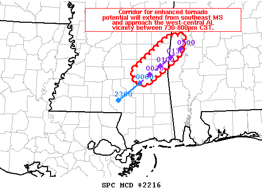
Areas affected…southeast MS into far west-central AL
Concerning…Tornado Watch 702…
Valid 170012Z – 170215Z
The severe weather threat for Tornado Watch 702 continues.
SUMMARY…A corridor for enhanced tornado potential will extend in
the near term across southeast MS with a discrete supercell. The
risk may continue into far west-central AL between 730-800pm CST.
DISCUSSION…Radar imagery shows a discrete supercell over Jones
County, MS with a messy supercell structure straddling Smith/Jasper
counties as of 610pm CST. The low-level airmass is gradually
moistening along the MS/AL border with surface dewpoints immediately
downstream of the supercells slowly rising into the upper 60s
degrees F. The observed 00z Slidell, LA sounding showed 1600 J/kg
MLCAPE and a 15 g/kg lowest 100mb mean mixing ratio. Farther north
ahead of the aforementioned storms, RAP forecast soundings show
enlarged low-level hodographs with around 300-350 m2/s^2 0-1km SRH
and around 1000 J/kg MLCAPE. The greater risk for a tornado or
series of tornadoes will likely accompany the discrete cell during
the next 1-2 hours.
Category: Alabama's Weather, ALL POSTS, Severe Weather
About the Author (Author Profile)
Scott Martin is an operational meteorologist, professional graphic artist, musician, husband, and father. Not only is Scott a member of the National Weather Association, but he is also the Central Alabama Chapter of the NWA president. Scott is also the co-founder of Racecast Weather, which provides forecasts for many racing series across the USA. He also supplies forecasts for the BassMaster Elite Series events including the BassMaster Classic.Subscribe
If you enjoyed this article, subscribe to receive more just like it.


