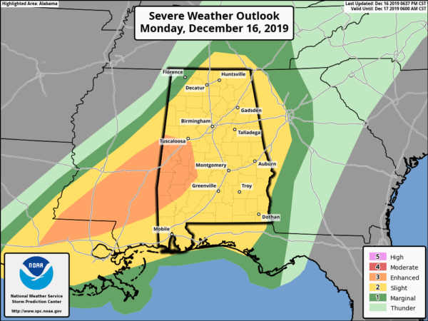
Enhanced Risk Of Severe Storms Continues For Parts Of Louisiana, Mississippi, & Alabama
…SUMMARY…
Numerous thunderstorms, some severe, will continue to affect parts of the Gulf States/Tennessee Valley tonight. A few tornadoes remain possible along with damaging winds.
…Gulf States/Tennessee Valley…
Positive-tilt trough continues to settle southeast with attendant height falls evident across the Mid-South/OH Valley region. In response to this feature, considerable amount of convection has developed within a 50-100 mi corridor from southern LA – central MS – northern AL – middle TN. Numerous long-lived supercells, some tornadic, have been noted within this corridor but recent trends suggest a more linear mode evolving, especially north of I-20. Over the last hour or so, more discrete supercells have congregated farther south across southern MS where greater buoyancy resides. Latest radar data suggests several long-lived supercells will track across southeastern portions of ww701 into west-central AL. This cluster of storms will necessitate focusing the highest severe probs along this corridor. Tornadoes remain possible with these storms. Have opted to increase severe probs a bit into western portions of GA to account for this activity maintaining some intensity toward the end of the period.
Farther north, well-defined bow-type squall line has evolved along the TN/AL border moving east at roughly 45kt. While an embedded tornado can not be ruled out with this organized bow, the primary severe threat should be winds.
Category: ALL POSTS
About the Author (Author Profile)
Scott Martin is an operational meteorologist, professional graphic artist, musician, husband, and father. Not only is Scott a member of the National Weather Association, but he is also the Central Alabama Chapter of the NWA president. Scott is also the co-founder of Racecast Weather, which provides forecasts for many racing series across the USA. He also supplies forecasts for the BassMaster Elite Series events including the BassMaster Classic.Subscribe
If you enjoyed this article, subscribe to receive more just like it.


