A New Tornado Watch Is Possible Over The Southern Portions Of The Area
Areas affected…Southeast Louisiana…Southern Mississippi and Alabama and portions of the Florida panhandle.
Concerning…Severe potential…Watch possible
Valid 170258Z – 170430Z
Probability of Watch Issuance…60 percent
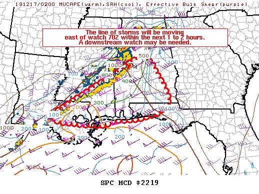
SUMMARY…The line of thunderstorms along a cold front will move east of watch 702 within the next 1 to 2 hours. A downstream watch may be needed.
DISCUSSION…The overall tornado threat has waned somewhat now that the pre-frontal supercells have been overtaken by the squall line. However, this line of storms will continue to pose a threat for both damaging winds and tornadoes given 1000 J/kg MLCAPE and 0-1 km SRH around 300-350 m2/s2. The greater severe weather threat will likely be confined to areas with low to mid 60s dewpoints which currently goes from near Birmingham southeastward to Tallahassee, FL. It is possible one or two supercells could develop out of the shallow convection currently across southern Mississippi into the Florida panhandle, but the greater threat will likely be associated with the squall line.
Considering the instability (1500 to 2000 J/kg) south of watch 702, there may be some threat of damaging winds and a few tornadoes as the front approaches southern Mississippi and Alabama, but this portion of the line has been mostly undercut by the cold-front, so the threat will likely remain less in this vicinity.
Category: Alabama's Weather, ALL POSTS, Severe Weather
About the Author (Author Profile)
Scott Martin is an operational meteorologist, professional graphic artist, musician, husband, and father. Not only is Scott a member of the National Weather Association, but he is also the Central Alabama Chapter of the NWA president. Scott is also the co-founder of Racecast Weather, which provides forecasts for many racing series across the USA. He also supplies forecasts for the BassMaster Elite Series events including the BassMaster Classic.Subscribe
If you enjoyed this article, subscribe to receive more just like it.


