A Quick Check On Our Situation Just After 10:00 PM
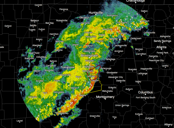
The ragged line of storms continue to push slowly across North/Central Alabama with the strongest part of the line is on the bow echo stretching from Alabaster to Selma. Two severe thunderstorm warnings and one tornado warning are active at this time.
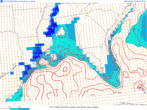
Instability seems to be dropping over the northern parts of the area with only a small zone of values reading at or just over 500 J/kg over the west-central parts of Central Alabama. The rest of the area has values less than that. That is good news as it will make it harder for these thunderstorms to build high into the atmosphere.
Wind shear values continue to be in the 50-70 knot range along with helicity values in the 400-550 m2/s2 range, both of which is well more than supportive for severe storms and the potential of rotating updrafts.
As you know, it doesn’t take much instability during these late fall and early winter severe setups to get severe storms to develop especially when there is warm moist air interacting with a very strong cold front.
With that being said, the severe threat will continue along and ahead of this line of storms through the rest of the night tonight and into the early morning hours on Tuesday. That was the main reason that a new Tornado Watch was issued for the central and eastern parts of Central Alabama until 4:00 am.
Category: Alabama's Weather, ALL POSTS, Severe Weather
About the Author (Author Profile)
Scott Martin is an operational meteorologist, professional graphic artist, musician, husband, and father. Not only is Scott a member of the National Weather Association, but he is also the Central Alabama Chapter of the NWA president. Scott is also the co-founder of Racecast Weather, which provides forecasts for many racing series across the USA. He also supplies forecasts for the BassMaster Elite Series events including the BassMaster Classic.Subscribe
If you enjoyed this article, subscribe to receive more just like it.


