A Quick Midday Check Shows A Few Showers; Potential For Stronger Storms Continues
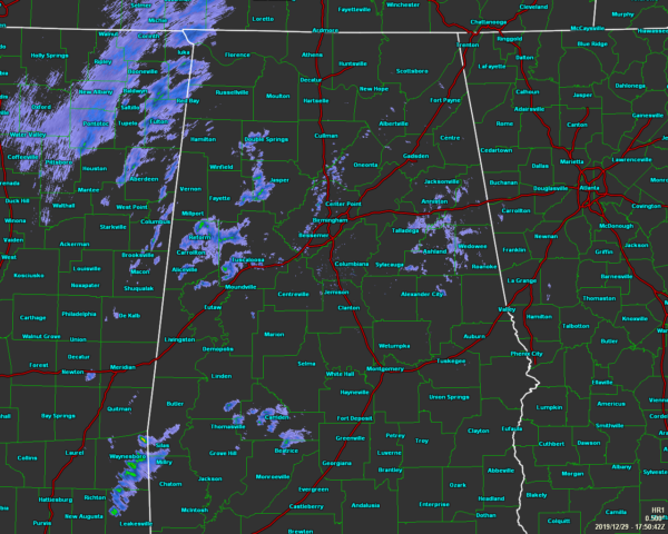
As we approach the noon hour across North/Central Alabama, we continue to have mainly cloudy skies across the area with some scattered light shower activity over the western and northwestern parts of the area. We also have a few very light showers or drizzle falling over the eastern parts of the area around and over the I-20 corridor.
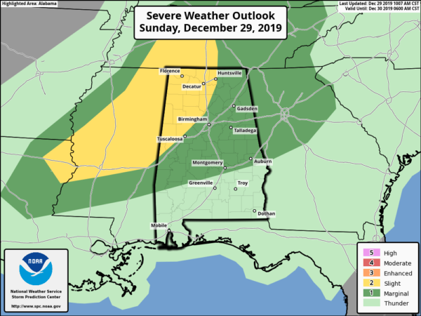
Locations west of a line from Huntsville (Madison Co.) to Sumiton (Walker Co.) to Gainesville (Sumter Co.) remain in a Slight Risk (level 2 of 5) for severe storms through the rest of the day. The rest of North/Central Alabama remains in a Marginal Risk (level 1 of 5) with the exception of those locations just south of a line stretching from Gordonville (Lowndes Co.) to Pike Road (Montgomery Co.) to Smiths Station (Lee Co.).
No real change with this update from the last as the latest model runs for this afternoon and tonight continues to show a low-end threat of isolated damaging wind gusts up to 60 MPH and a brief tornado or two.
The main window for the potential of stronger to severe storms look to be from 2 pm to midnight, but as the system is expected to weaken as it moves eastward through the area, the end time could be trimmed.
At this point, the cloud cover is holding the instability in check. If this continues throughout the afternoon hours, the threat for severe storms will be less. If we get any significant breaks in the cloud cover during the afternoon, we could see that instability increase and could possibly lead to more active weather.
While this is a low-end severe weather threat, we still need to be vigilant and be ready just in case your location goes under a warning. Have your safe place and supplies ready, along with having fresh batteries in your NOAA WeatherRadio. Also, have those batteries charged in your smartphones and have your WEAs (Wireless Emergency Alerts) turned on.
We’ll continue to have updates throughout the day.
Category: Alabama's Weather, ALL POSTS, Severe Weather
About the Author (Author Profile)
Scott Martin is an operational meteorologist, professional graphic artist, musician, husband, and father. Not only is Scott a member of the National Weather Association, but he is also the Central Alabama Chapter of the NWA president. Scott is also the co-founder of Racecast Weather, which provides forecasts for many racing series across the USA. He also supplies forecasts for the BassMaster Elite Series events including the BassMaster Classic.Subscribe
If you enjoyed this article, subscribe to receive more just like it.


