A Quick Check On Our Weather As We Approach 5:00 PM
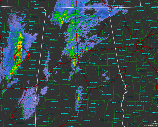
As we are starting to approach the 5:00 pm hour across North/Central Alabama, we see that this first wave of rain and thunderstorms have stayed well-behaved at this point, but look back to our west over the eastern portions of Mississippi, we see a Tornado Warning in effect for portions of Choctaw, Oktibbeha, Winston, Webster, and Clay counties until 4:45 pm. A storm capable of producing a tornado was being detected on radar just northwest of Louisville. It was moving to the northeast at 55 MPH. That is currently the only warning in effect across the southeast.
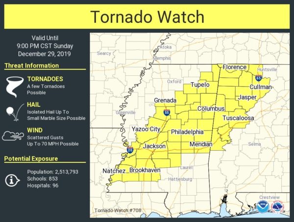
A Tornado Watch continues until 9:00 pm tonight for Colbert, Cullman, Franklin, Lauderdale, Lawrence, Limestone, Morgan, Fayette, Greene, Lamar, Marion, Pickens, Sumter, Tuscaloosa, Walker, and Winston counties in North/Central Alabama.
The main window for stronger to severe storms for the area will be from now through midnight tonight.
The system is expected to weaken as it moves eastward through the area later tonight, and that is the reason why the Storm Prediction Center did not extend the Tornado Watch and further to the east.
Category: Alabama's Weather, ALL POSTS, Severe Weather
About the Author (Author Profile)
Scott Martin is an operational meteorologist, professional graphic artist, musician, husband, and father. Not only is Scott a member of the National Weather Association, but he is also the Central Alabama Chapter of the NWA president. Scott is also the co-founder of Racecast Weather, which provides forecasts for many racing series across the USA. He also supplies forecasts for the BassMaster Elite Series events including the BassMaster Classic.Subscribe
If you enjoyed this article, subscribe to receive more just like it.


