

Increasing Clouds At Midday; Marginal Risk Introduced For Parts Of Central Alabama For Thursday
Conditions At Midday

As we are approaching the midday hour on this first day of 2020, we are seeing some thinner clouds starting to stream over a good portion of Central Alabama which are filtering out some of the sunshine. Other than that, the skies are still mostly sunny. Temperatures as of 11:00 am were in the upper 40s to the mid-50s across the area. Birmingham was at 51 degrees. Sylacauga was the cool spot at 47 degrees while Montgomery and Troy were leading the way in “warmth” at 54 degrees.
Those clouds will continue to move in from the west and southwest ahead of the system that will start affecting North/Central Alabama on Thursday. We’ll stay dry throughout the remainder of your “Hump Day,” but rain chances really start to climb from northwest to southeast after midnight. Afternoon highs will reach the mid-50s to the lower 60s with overnight lows in the 40s.
Marginal Risk For Severe Storms In Effect For Parts Of The Area On Thursday

The latest Day 2 Outlook from the Storm Prediction Center now has much of the west and southwestern parts of Central Alabama in a Marginal Risk (level 1 of 5) of severe storms on Thursday. This includes the cities of Birmingham, Tuscaloosa, Reform, Eutaw, Marion, Selma, Greensboro, and Demopolis. The latest update states that there is a low-end risk of damaging wind gusts and a brief tornado in the risk locations. With the amount of shear expected, we could see a few storms that may start to bow with higher wind gusts. The limiting factor with this system will be the cloud cover and limited daytime heating, even those the forecast highs will be in the upper 50s to the upper 60s for most, while a few locations in the south could reach 70 degrees.
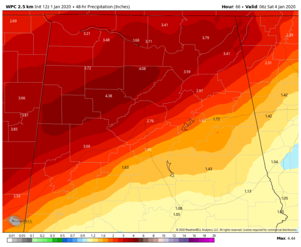
Nevertheless, we could see some flash flooding issues as rainfall totals from 12 am Thursday through 12 am Saturday could reach as high as over 4 inches in the north and northwestern parts of the area, with 2-3 inch totals possible along and north of the I-20 and I-59/20 corridors. 1-2 inches are possible south of that.

An Areal Flood Watch is up for all counties in North Alabama and for the following counties in Central Alabama until 6:00 pm Friday: Blount, Cherokee, Etowah, Fayette, Greene, Jefferson, Lamar, Marion, Pickens, St. Clair, Sumter, Tuscaloosa, Walker, and Winston. We’ll have more updates on this new potential for severe storms and on the risk of heavy rainfall.
With the Birmingham Bowl taking place on Thursday with kickoff at 2 pm and the new severe risk does include the city of Birmingham, please remain weather aware if you are heading to the game. While severe storms are not likely, there is a low-end chance of a strong storm moving through especially during the afternoon hours.
Category: Alabama's Weather, ALL POSTS, Severe Weather
About the Author (Author Profile)
Scott Martin is an operational meteorologist, professional graphic artist, musician, husband, and father. Not only is Scott a member of the National Weather Association, but he is also the Central Alabama Chapter of the NWA president. Scott is also the co-founder of Racecast Weather, which provides forecasts for many racing series across the USA. He also supplies forecasts for the BassMaster Elite Series events including the BassMaster Classic.Subscribe
If you enjoyed this article, subscribe to receive more just like it.


