

Tornado Watch Possible To Our West
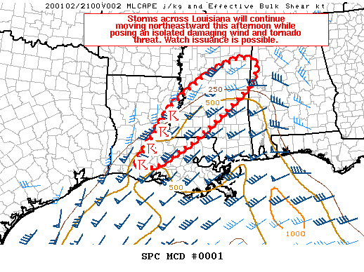
From The Storm Prediction Center: Storms across Louisiana will continue moving northeastward this afternoon while posing an isolated damaging wind and tornado threat. Watch issuance is possible in the next couple of hours.
Storms have recently developed in a southwest-to-northeast oriented band over parts of Louisiana as large-scale ascent associated with an approaching upper trough gradually overspreads this area. Surface pressure falls around 2 to 3 MB in the past two hours have been observed from east Texas across Louisiana and into much of Mississippi and western Alabama. Short-term guidance suggests a weak low will consolidate over central Louisiana and then develop northeastward along a surface boundary into Mississippi and eventually northwestern Alabama. A weakly unstable airmass characterized by mid-60s to lower 70s surface dewpoints will exist downstream of ongoing convection in Louisiana. Still, mixed-layer instability is expected to reach no more than 500-750 J/kg across the warm sector this afternoon and early evening owing to modest diurnal heating and poor mid-level lapse rates.
Recent VWP estimates from area radars show generally southwesterly winds rapidly strengthening with height through mid/upper levels, which is supporting 50-70+ kt of effective bulk shear. But, enhanced flow aloft should remain largely parallel to the orientation of the convective band, which will probably tend to limit the potential for discrete cells. Storms may also have the tendency to become undercut by their own outflow, especially with eastward extent into MS and far western AL. Regardless, isolated strong to damaging winds appear to be the main threat as these storms move northeastward this afternoon and early evening given the strong flow present just off the surface. A couple of tornadoes may also occur since strong low-level shear will be present ahead of the line.
Across east-central MS and far western AL, ongoing precipitation associated with strong low-level warm air advection is forecast to shift northeastward over the next several hours. Although the near-term severe risk across this area is low, some threat may eventually exist as the low-level airmass gradually destabilizes from south to north later this afternoon and evening.
Radar and observational trends will continue to be monitored for signs of increasing storm intensity and organization, with watch issuance possible over the next couple of hours.
Category: Alabama's Weather, ALL POSTS, Severe Weather
About the Author (Author Profile)
Scott Martin is an operational meteorologist, professional graphic artist, musician, husband, and father. Not only is Scott a member of the National Weather Association, but he is also the Central Alabama Chapter of the NWA president. Scott is also the co-founder of Racecast Weather, which provides forecasts for many racing series across the USA. He also supplies forecasts for the BassMaster Elite Series events including the BassMaster Classic.Subscribe
If you enjoyed this article, subscribe to receive more just like it.


