

Sunny Skies At Midday; Increased Potential For Severe Storms On Saturday
Conditions At 11:00 AM
After the weak system moved through during the overnight and pre-dawn hours this morning, skies have now cleared out completely across Central Alabama. Temperatures across the area were in the lower 50s to the lower 60s as of 11:00 am. Birmingham was at 54 degrees while the warm spot was Montgomery at 61 degrees. Cullman was the cool spot at 50 degrees.
Weather For The Rest Of Your Tuesday
Skies will remain sunny for the rest of the daylight hours, but we will continue to have some breezy conditions as winds will be out of the northwest averaging around 5-15 MPH with gusts up to 25 MPH possible at times. Afternoon highs will be seasonal, reaching the mid-50s to the lower 60s across the area. Clear and cold for tonight with overnight lows reaching the upper 20s to the mid-30s.
Not Much To Complain About On Wednesday Except Having To Work
“Hump Day” will be an absolutely fantastic day across Central Alabama with slightly above average temperatures for this time of the year. Skies will be sunny and highs will be up in the upper 60s to the lower 60s. And just in case if you were wondering if winter would return to Central Alabama anytime soon, the answer looks to be no. Highs look to be in the upper 50s to the upper 60s throughout the next 15 days, with a couple of 70-degree reading possible for Friday and Saturday.
Risk For Strong To Severe Storms Has Increased For Saturday

The Storm Prediction Center has now upgraded much of Mississippi and Alabama to an Enhanced Risk for severe storms during the day on Saturday (30% or higher probability for severe storms within 25 miles of a given location).
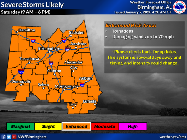
The National Weather Sevice office in Birmingham has already put out an outlook with all of its counties in an Enhanced Risk for severe storms for Saturday with the rough timing estimate from 9:00 am to 6:00 pm. Huntsville has not put out an outlook graphic as of yet, but it will probably be out before you know it.
It is starting to look like the potential is there for this to be a significant severe weather event with all modes of severe weather possible: a few tornadoes, damaging winds up to 70 MPH, and large hail up to 1 inch in diameter. We’ll have a better understanding of how high the threats will be for each of those as the higher-resolution, convection-allowing models come into view which will be around 60 hours from the start of the event.
Afternoon highs look to top out in the upper 60s to the mid-70s with dewpoints will be in the mid-60s to potentially as high as 70 degrees. That will help fuel the instability out ahead of the cold front in the warm sector. We’ll already have plenty of shear and helicity in place, so the potential for rotating storms is already showing on these longer-range models.
Bottom Line: Severe storms are possible on Saturday and now is the time to get prepared. Refresh or create a severe weather safety kit and have a place of safety ready to go. Buy and install fresh batteries into your portable electronics that you will receive warnings on, especially those NOAA WeatherRadios.
If you live in a mobile or manufactured home, go ahead and plot out your plan of safety. Check to see if you can hang out with a friend, relative, or neighbor that has a storm shelter or reinforced safe room in their house. If that is not an option, find out where the closest community storm shelter is located to your home. DO NOT try to ride out a tornado warning in a mobile or manufactured home or in your vehicle.
This is not meant to scare you and make you nervous… just to let you know that the potential for severe storms is there for Saturday. This does not have the look of an April 27, 2011 outbreak to it, but all it takes is for one tornado to come down your street to make it your April 27th. Stay weather aware and check back for updates.
Category: Alabama's Weather, ALL POSTS, Severe Weather
About the Author (Author Profile)
Scott Martin is an operational meteorologist, professional graphic artist, musician, husband, and father. Not only is Scott a member of the National Weather Association, but he is also the Central Alabama Chapter of the NWA president. Scott is also the co-founder of Racecast Weather, which provides forecasts for many racing series across the USA. He also supplies forecasts for the BassMaster Elite Series events including the BassMaster Classic.Subscribe
If you enjoyed this article, subscribe to receive more just like it.


