

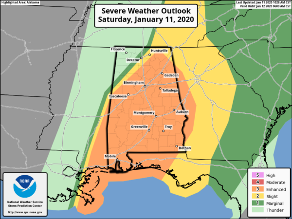
Enhanced Risk Continues For Almost All Of North/Central Alabama In Latest SPC Update
THERE IS AN ENHANCED RISK OF SEVERE THUNDERSTORMS OVER PARTS OF THE CENTRAL GULF COAST STATES……
…SUMMARY…
Scattered to potentially widespread damaging winds are expected across parts of the Central Gulf Coast states and Tennessee Valley. The greatest threat for tornadoes will be across portions of Alabama.
…TN/MS/AL/GA…
The intense squall line extends southward across middle TN into northwest AL and eastern MS. The air mass ahead of the line is modestly unstable with dewpoints in the low/mid 60s. Little daytime heating is expected, but afternoon MLCAPE values as high as 1000 J/kg may be realized over central AL later today. Given the extremely strong wind fields, this parameter space will remain conducive for damaging winds and QLCS mesovortices along the squall line. The warm sector continues to show a little capping per recent soundings in northern AL. If the capping erodes, the potential for a few discrete supercells ahead of the line would increase, along with a potential for a strong tornado or two.
Category: Alabama's Weather, ALL POSTS, Severe Weather
About the Author (Author Profile)
Scott Martin is an operational meteorologist, professional graphic artist, musician, husband, and father. Not only is Scott a member of the National Weather Association, but he is also the Central Alabama Chapter of the NWA president. Scott is also the co-founder of Racecast Weather, which provides forecasts for many racing series across the USA. He also supplies forecasts for the BassMaster Elite Series events including the BassMaster Classic.Subscribe
If you enjoyed this article, subscribe to receive more just like it.


