New Tornado Watch Coming Shortly
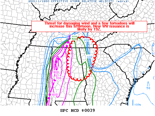
SUMMARY… Threat for damaging wind and a few tornadoes will increase this afternoon. Watch issuance is likely by 1:00 PM.
DISCUSSION… An extensive QLCS has recently intensified across portions of western AL, with at least one confirmed tornado noted earlier in Pickens County. Gradually increasing downstream instability (noted in objective mesoanalysis and recent SWIRLL soundings) will favor maintenance of this system as it moves into northeast AL and adjacent portions of northwest GA and southern TN. Very strong wind profiles will also spread eastward with time, with 1 km AGL flow of 60-70 kt and effective SRH expected to increase into the 450-650 m2/s2 range. This powerful wind field will continue to support the potential for relatively widespread damaging wind, and also embedded circulations capable of producing at least brief tornadoes. New watch issuance is expected by 19Z to cover these threats from northeast AL into northwest GA and southern TN.
Category: Alabama's Weather, ALL POSTS, Severe Weather
About the Author (Author Profile)
Scott Martin is an operational meteorologist, professional graphic artist, musician, husband, and father. Not only is Scott a member of the National Weather Association, but he is also the Central Alabama Chapter of the NWA president. Scott is also the co-founder of Racecast Weather, which provides forecasts for many racing series across the USA. He also supplies forecasts for the BassMaster Elite Series events including the BassMaster Classic.Subscribe
If you enjoyed this article, subscribe to receive more just like it.


