Latest SPC Mesoscale Discussion On Eastern Parts Of The Area
The severe weather threat for Tornado Watch 15 continues.
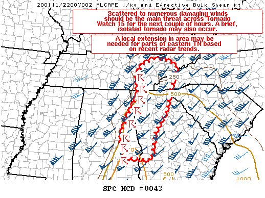
SUMMARY… Scattered to numerous damaging winds should be the main severe threat across Tornado Watch 15 for the next couple of hours. A brief/isolated tornado may also occur. A local extension in the area may be needed for parts of eastern Tennessee based on recent radar trends.
DISCUSSION… Numerous damaging wind reports have occurred across central/eastern AL over the past several hours as a well-established squall line has moved east-northeastward. Damaging winds of 50-60+ mph will likely remain the primary severe risk across eastern AL into western GA and parts of southeastern TN in the short term as weak but sufficient instability exists downstream of the ongoing convection. In addition, strong low-level shear, as shown in various VWPs from this region, will support an embedded isolated tornado threat for at least the next couple of hours. Weak destabilization has also occurred into more of eastern TN this afternoon, which may necessitate a northward extension in the area of Tornado Watch 15 for this region.
Category: Alabama's Weather, ALL POSTS, Severe Weather
About the Author (Author Profile)
Scott Martin is an operational meteorologist, professional graphic artist, musician, husband, and father. Not only is Scott a member of the National Weather Association, but he is also the Central Alabama Chapter of the NWA president. Scott is also the co-founder of Racecast Weather, which provides forecasts for many racing series across the USA. He also supplies forecasts for the BassMaster Elite Series events including the BassMaster Classic.Subscribe
If you enjoyed this article, subscribe to receive more just like it.


