

Strong Storm Moving Into Franklin County
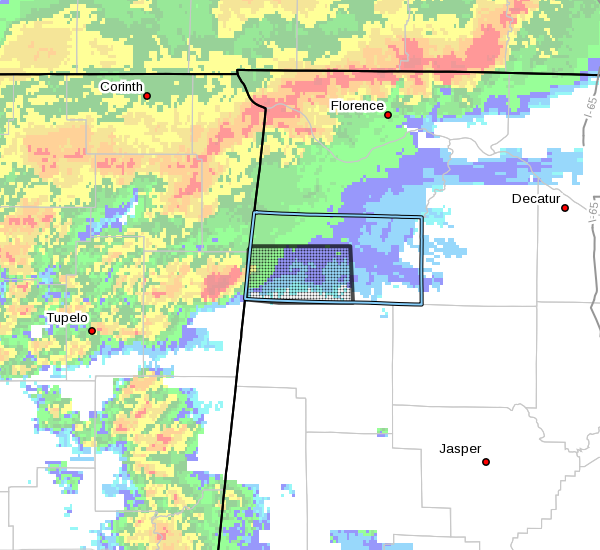
…SIGNIFICANT WEATHER ADVISORY FOR SOUTHWESTERN FRANKLIN COUNTY
UNTIL 945 PM CST…
At 859 PM CST, Doppler radar was tracking a strong thunderstorm near
Fairview, or 7 miles southwest of Red Bay, moving east at 35 mph.
Pea size hail and winds in excess of 40 mph will be possible with
this storm.
Locations impacted include…
Red Bay, Belgreen, Vina, Hodges, Atwood, Duketon, Little Bear Creek
Reservoir and Halltown.
PRECAUTIONARY/PREPAREDNESS ACTIONS…
Strong gusty winds will be capable of knocking down small tree limbs
along with other small unsecured items. Seek safe shelter until this
storm has passed.
Very heavy rainfall is also occurring with this storm, and may lead
to localized flooding. Do not drive your vehicle through flooded
roadways.
Frequent cloud to ground lightning is occurring with this storm.
Lightning can strike several miles away from a thunderstorm. Seek a
safe shelter inside a building or vehicle.
Category: Alabama's Weather, ALL POSTS, Severe Weather
About the Author (Author Profile)
Scott Martin is an operational meteorologist, professional graphic artist, musician, husband, and father. Not only is Scott a member of the National Weather Association, but he is also the Central Alabama Chapter of the NWA president. Scott is also the co-founder of Racecast Weather, which provides forecasts for many racing series across the USA. He also supplies forecasts for the BassMaster Elite Series events including the BassMaster Classic.Subscribe
If you enjoyed this article, subscribe to receive more just like it.


