Showers In The North & South, Dry Slot Over Central Parts Of The Area At Midday
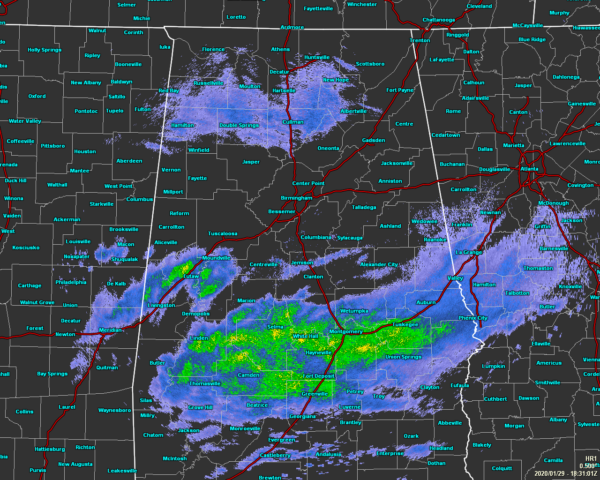
Radar at 12:31 pm shows a decent coverage of showers mainly south of a line from Moundville to Jemison to Roanoke, while much of the rest of Central Alabama is dry. The exception to that is for the very light showers or sprinkles that are falling over the extreme northern parts of the area, mainly north of Hamilton to Double Springs, and Cullman. Temperatures as of the 12:00 pm round-up were in the mid-40s to the mid-50s across the area. Troy was the cold spot at 46 degrees while the warm spots were Talladega and Tuscaloosa at 54 degrees. Birmingham was not too far behind at 53 degrees.
We’ll continue to have the likely risk of widespread showers across the southern half of the area throughout the rest of the afternoon and into the early evening hours, with a lesser risk of a few light showers or drizzle over the northern portions of Central Alabama. Afternoon highs may reach the lower to mid-50s, but the shower activity may hamper a spot or two from reaching those expectations. For tonight, those shower chances will diminish quickly before we reach the late-night hours and patchy dense fog will be possible in the locations that received rainfall. Other than the fog, clouds will be decreasing across the area and lows should drop into the mid to upper 30s across the area.
After the patchy morning fog lifts out of the area during the morning hours, we’ll be left with a fantastic Thursday across Central Alabama. Skies will be mostly sunny and we’ll be dry. Afternoon highs will be in the upper 50s to the lower 60s across the area. The next chance of rain looks to return early on Friday.
ABC 33/40’s Storm Spotter Training
The Annual ABC 33/40 Storm Spotter Training will take place at the Hoover Met on Saturday, February 8th starting at 9:30 am, with doors opening as early as 8:45 am. There is no cost and no need to register. Just show up with a curious mind. There will be a basic class and an advanced class. James Spann will even be speaking during the downtime between classes. A complete schedule will be coming out soon. Keep an eye on Spann’s Facebook page for updates.
NWS Birmingham SKYWARN Storm Spotter Training
The National Weather Service office in Birmingham will be offering several online Basic Spotter Courses and a single Advanced Spotter Course over the next few months. These online courses are FREE and are open to anyone who would like to learn more about what it takes to be a spotter and what to look for. More information can be found on the NWS Birmingham’s website, just CLICK HERE to visit the site.
On This Day In Weather History
1780 – On the coldest morning of a severe winter the mercury dipped to 16 degrees below zero at New York City, and reached 20 degrees below zero at Hartford CT. New York Harbor was frozen for five weeks, allowing a heavy cannon to be taken across the ice to fortify the British on Staten Island.
Category: Alabama's Weather, ALL POSTS
About the Author (Author Profile)
Scott Martin is an operational meteorologist, professional graphic artist, musician, husband, and father. Not only is Scott a member of the National Weather Association, but he is also the Central Alabama Chapter of the NWA president. Scott is also the co-founder of Racecast Weather, which provides forecasts for many racing series across the USA. He also supplies forecasts for the BassMaster Elite Series events including the BassMaster Classic.Subscribe
If you enjoyed this article, subscribe to receive more just like it.


